

Bulletin 51, New Jersey Geodetic Control Survey Bench Marks in ...
Bulletin 51, New Jersey Geodetic Control Survey Bench Marks in ...
Bulletin 51, New Jersey Geodetic Control Survey Bench Marks in ...

You also want an ePaper? Increase the reach of your titles
YUMPU automatically turns print PDFs into web optimized ePapers that Google loves.
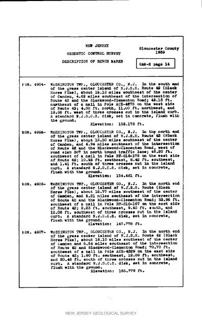
NEW _R HEYOlouceste r Count7GEODETIC CONTROL SURVE_ 1939DF_SCRIPTION OF BENCH MARKS I C_.H page 14 InON° 4904- WASHINGTON TWP.p GLOUCESTER CO°, N.J. In the sou_h @_dof the grass center island of N.J.S.H. Route 42 (l_,aokHorse Pike), about 15.18 miles southeast of the centerof Camden, 4.62 miles southeast of the <strong>in</strong>terseoti_ ofRoute 42 and the Blaekwood-Clementon Road; 45.15 ft.namtheast of a nell <strong>in</strong> Pole ACE-4_75 on the west s_deof Reute 49; 4.00 ft. north, 11.00 ft. northwest, and19.86 ft. west of three crosses cut <strong>in</strong> the island curb.A standard N.J.GoC°S. disk, set <strong>in</strong> concrete, flush withthe ground.Elevation: 156.178 ft.EON, 4906- WASHINGTON TW?., GLOUCESTER CO., N.J. In th_ north endO_ the grass canter island of N.J.S.H. Route" 42 (B%aokHorse Pike), abogt 15,50 miles southeast of the centerof Camden, and 4.94 miles southeast of the <strong>in</strong>tAsrseotl_of Route 42 and the Blaok_eood-Glement_ Roe_, west ofroad slab _07 <strong>in</strong> nePth bo%tnd tz,Jfflc lane; 46.20 ft.southwest Of a nell <strong>in</strong> P_e BT-818-_qS on the east aideof Route 42; 10.95 ft. sovtheast, 8.42 ft. southeastand 1.41 ft. south of thee crol[,ees cut <strong>in</strong> the lel_curb. A stando_-d N.J.G.C.S. disk, set <strong>in</strong> concrete,flush with the gx_._evat lea3: 154.481 ft._ON. 4906- WASHINGTON TWP., GL_CESTER GO., N.J. _ the nol_h endof the g1"ass center Island of N.J'.S.H. Route (BlaokHares Pike), about 15.77 miles southeast of the centerof Camden, and 5.21 miles southeast ef the <strong>in</strong>tersectionof Route 42 and the Blackwood-Clementon Road; 8_.86 ft.southwest of a nail <strong>in</strong> Pole BT-818-167 cm the east sideof Route 42; 2.23 ft. southeast, 9.40 ft. south, and12.06 ft. southwest of three crosses cut <strong>in</strong> the islandcurb. A standard N°J.G.C.S. dlsk, set In concrete,flush with the ground.Elevat lee _ 147.778 ft._ON. 4907- WASHINGTON T_P., GLOUCESTER CO., N.J. In the north endof the grass center island of N.J.S.H° Route 42 (BlackHorse Pike), about 16.10 miles southeast of the centerof Camden and 5.54 miles southeast of the Intersectionof Route 42 and Blackwood-Clementc_ Road; 70.70 ft.southwest of a nell <strong>in</strong> Pole ACE-43_9 on the east sideOf Route 42; 1.90 ft. s_theaet, 12.89 ft. southeast,and 20.46 ft. south of t_ree orosses cut <strong>in</strong> the Islandcurb. A standard N.J.GoC.S. disk, set <strong>in</strong> concrete,flush with the _roundoF-levatlon: 165.779 ft.NEW JERSEY GEOLOGICAL SURVEY


