

Bulletin 51, New Jersey Geodetic Control Survey Bench Marks in ...
Bulletin 51, New Jersey Geodetic Control Survey Bench Marks in ...
Bulletin 51, New Jersey Geodetic Control Survey Bench Marks in ...

You also want an ePaper? Increase the reach of your titles
YUMPU automatically turns print PDFs into web optimized ePapers that Google loves.
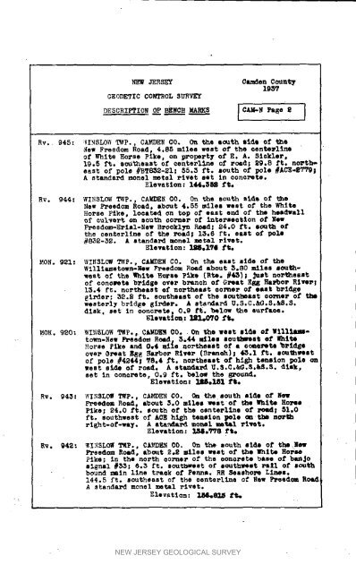
NEW JERSEY Camden County1937GE 0DETIC C0_SROL SURVEYDESCRIPTION OF BENCH MARKS [CAM-N Page, 1Rv. 945: VINSLOW TWp., CAMDEN C0, On the south side of theJew Freedom Road, 4.85 miles west of the een_wllneof White Horse Pike, on property Of E. A. <strong>51</strong>ekler,19.5 ft. southeast of centerllne of rc4d; 29.8 ft. no_theastof pole #HT8_2-SI; 85.3 ft. south of pole #ACE-S_!A standard monel metsl _ivet set Sn concrete.Elevation: I_.SK ft.Hv. 944: WINSLOW _WP., CAMDEN C0. On the south slde of the<strong>New</strong> FreedOm Road, abOUt 4.55 miles west of the WhiteHorse Pike, located on top of east end of t_ headvallof cul_e_t on south eoPner of _ntersestion of <strong>New</strong>Freed_-Erlml-<strong>New</strong> Brooklyn R_md; $4.0 ft. sOUth ofthe oenterl<strong>in</strong>e of the road; 13.5 ft. east of pole#835-35. A standard monel metal i-ivet,Elevation: _.I?I ft.MON. 921: WINSLOW TWP., CA_E_ CO. On the east side of theWllliamstown-<strong>New</strong> F_eedom Road about _o80 miles sOUthwestof the 1hits Horse pike (Rteo #43); _ust northeastof oonoeete bridge over b_anch of Great Eg 8 NaFboP River;13.4 ft. northeast e[ northeast sooner of east bridgegirder; 32._ ft. southeast of the southeast corner of thewesterly bridge girder. A steward U.S.C.&G.S._S.3.disk. set <strong>in</strong> oonc_ete_ 0,9 fro helow the supPLes._levati_: 121.@70 f_HOR. 920: WI_ISL0W T_P., C_S CO. On the '_est sido of W111_-town-Now F_eedom Reed, 3,44 stiles lOUt_eest of _hlteHorse _£ke and 0.4 mile no_theas_ of a coyote _rid_eover @teat Egg I_a_bor River (B_anoh); _3.1 ft. southwestof pole #4244; _8.4 _t. northeast Of high tension pole onwest side of road. A standard U.5.C._G.R._._. dlek_set <strong>in</strong> concrete, 0.9 ft. below the _-ound.Elevation: _ela_ ft.Rv. 943: WINSLO_ TWp., CAMDEN CO. _ the south side ofFreedc_ Road, about _.0 miles _est Of the _hi_e _rnePike; _4.0 ft. south of the csnte_llne o_ I_| <strong>51</strong>.0f_. soathwest of ACE high tension pole _tbe northright-of-way. A standard mortal metal rivet.Elevation: _._8 fieRv. 94_: _L_ _., CAL_EN CO. On the south side of the HewFreedom Road, about _.2 _les west of the _nlte HOP_Pike; <strong>in</strong> the north corner of the concrete base of banjosignal #53; 6.3 ft. southwest of southwest Pa_l of sOUthbound ma<strong>in</strong> l<strong>in</strong>e track of Parma. RR Seashore L<strong>in</strong>es.144.5 ft. southeast of the eenterl<strong>in</strong>e of Hew F_eedc_ Ro_A standard monel metal rivet.Elevation: I_8_ f_NEW JERSEY GEOLOGICAL SURVEY


