Instruction Manual - GME
Instruction Manual - GME
Instruction Manual - GME

You also want an ePaper? Increase the reach of your titles
YUMPU automatically turns print PDFs into web optimized ePapers that Google loves.
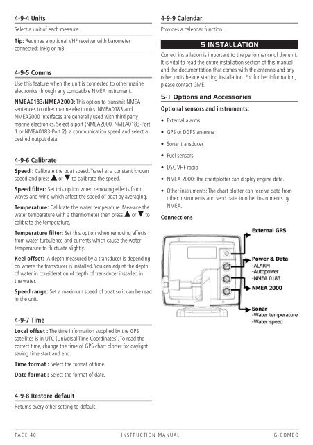
4-9-4 UnitsSelect a unit of each measure.Tip: Requires a optional VHF receiver with barometerconnected: InHg or mB.4-9-5 CommsUse this feature when the unit is connected to other marineelectronics through any compatible NMEA instrument.NMEA0183/NMEA2000: This option to transmit NMEAsentences to other marine electronics. NMEA0183 andNMEA2000 interfaces are generally used with third partymarine electronics. Select a port (NMEA2000, NMEA0183-Port1 or NMEA0183-Port 2), a communication speed and select adesired output data.4-9-6 CalibrateSpeed : Calibrate the boat speed. Travel at a constant knownspeed and press or to calibrate the speed.Speed filter: Set this option when removing effects fromwaves and wind which affect the speed of boat by averaging.Temperature: Calibrate the water temperature. Measure thewater temperature with a thermometer then press or tocalibrate the temperature.Temperature filter: Set this option when removing effectsfrom water turbulence and currents which cause the watertemperature to fluctuate slightly.Keel offset: A depth measured by a transducer is dependingon where the transducer is installed. You can adjust the depthof water in consideration of depth of transducer installed inthe water.Speed range: Set a maximum speed of boat so it can be readin the unit.4-9-9 CalendarProvides a calendar function.5 INSTALLATIONCorrect installation is important to the performance of the unit.It is vital to read the entire installation section of this manualand the documentation that comes with the antenna and anyother units before starting installation. For further information,please contact <strong>GME</strong>.5-1 Options and AccessoriesOptional sensors and instruments:• External alarms• GPS or DGPS antenna• Sonar transducer• Fuel sensors• DSC VHF radio• NMEA 2000: The chartplotter can display engine data.• Other instruments: The chart plotter can receive data fromother instruments and send data to other instruments byNMEA.Connections4-9-7 TimeLocal offset : The time information supplied by the GPSsatellites is in UTC (Universal Time Coordinates). To read thecorrect time, change the time of GPS chart plotter for daylightsaving time start and end.Time format : Select the format of time.Date format : Select the format of date.4-9-8 Restore defaultReturns every other setting to default.PAGE 40 INSTRUCTION MANUAL G-COMBO