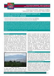
1 - Acta Technica Corviniensis
1 - Acta Technica Corviniensis
1 - Acta Technica Corviniensis

Create successful ePaper yourself
Turn your PDF publications into a flip-book with our unique Google optimized e-Paper software.
made on demand. In this type of protocol designactive routes between sender and receiver nodes isdetermined by making route discovery. Routediscovery is made by flooding network with routerequest and receiving route response packets innetwork. Such phenomena, helps nodes to conservepower as there are no periodic signals to respond.These MANET protocols are not suitable for VANET, asdiscovering routing path is time consuming asvehicular node’s speed is high.Hierarchical or Hybrid: In MANET routing protocol likeZRP [4], represent this category that uses the hybridapproach to improve scalability of routing protocol.By considering proactive and reactive mechanisms,ZRP divides network in intra and inter zones, whereintra‐zone protocols are proactive and inter‐zoneprotocols are reactive. Although this protocolimproves scalability, lack of implementation feasibilitymakes this routing aspect unsuitable for VANET.Position‐based: Position based routing protocols useslocation aided approach for MANET.In VANET vehicular nodes either communicate withanother vehicle (V2V) or road side vehicle (V2R). Inexisting infrastructure and ad hoc nodes of IEEE 802.11wireless standard the time required to authenticateand associate with Basic Service Set (BSS) is too longto be considered by VANET. Therefore 802.11pstandard will provide wireless devices with ability tocommunicate through short‐duration messages,necessary to communicate between a high speedvehicle and a stationary roadside unit (V2R) includinghigh speed vehicle (V2V). This mode of operation isknown as Wireless Access in Vehicular Environment(WAVE) [19].Although this V2V communication decentralized, it isrobust and supports the low data transport times foremergency [10] warning, Such thing is not feasiblewith roadside cellular base station as they are oftenoverwhelmed by calls in emergency, due to lack ofload balancing mechanism to avoid congestion innetwork [5].In MANET the proposed routing protocol LAR, usesinformation about location through geographiccoordinates or relative position of nodes to generateroute information thus by reducing overhead oftraditional flooding mechanism. Moreover locationservice may be built into nodes or distributed locationservices may be utilized [12, 5].The position based routing approach was designed forMANET routing protocol called Greedy PerimeterStateless Routing (GPSR) [25]. In this greedyforwarding strategy is used to forward messagestoward known destination. However if at one or multihop, there are no nodes in direction of destinationthen it uses the perimeter mode. Usage of suchACTA TECHNICA CORVINIENSIS – Bulletin of Engineeringrouting strategy in VANET is not efficient as in urbanarea radio obstruction restricts the effective routeand usage of perimeter mode is often required.During obstruction this perimeter mode uses thecreated planner graph that causes the message to bedelivered immediate node instead of farthestreachable node. Thus more nodes will carry messages,eventually increasing delays. Such inefficiency can alsocause messages to be delivered in wrong directionwhen node moves from communication range of onenode to another.As a result VANET uses Geographic Source Routing(GSR) [11]. This particular routing mechanism usesDijkstra’s shortest path algorithm to find shortestpath between source and destination. Using staticstreet map in piror and location information abouteach node, source forwards the message todestination and computes route to destination usingDijkstra’s shortest path algorithm. The sourcemessage computes the sequence of intersection thatmust be traversed in order to reach destination.Although this algorithm is VANET specific it does notconsider vehicle density, however authorsacknowledges this and can see a potential to improvethis routing mechanism.Another position based routing protocol calledSpatially Aware packet Routing (SAR) [16], tries toprevent limitations of recovery strategy used by GPSRof MANET. It is similar to GSR, but relies upon theexternal service such as Geographical InformationService (GIS) to extract street map and construct‘spatial model’ to calculate shortest path to routepacket to a destination. When shortest path isdecided, unlike GSR, it determines the geographicallocations that need to be travelled in embedded inpacket header. When node needs to forward packet ituses this immobile physical location information toroute packet to next geographic location. Thus itavoids the greedy strategy like GSR towarddestination. Author does provide recovery strategy ifforwarding node cannot find next location specified inpacket header. In one method it suggests the usage ofsuspension buffer to store information till node findssuitable location. In another method node greedilyforwards packet to destination. Usage of suspensionbuffer provides the high packet delivery ratio withexpense of delay compare to no recovery strategy inSAR.Unlike GSR, Anchor‐based Street and Traffic (A‐STAR)[20] aware routing uses bus routes to find routes withhigh probability for packet delivery. It uses thegeographic forwarding points to route packet todestination, including route information to determinetraffic density. However this static approach is less1022012. Fascicule 3 [July–September]