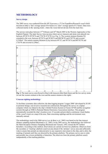
METHODOLOGYSurvey designThe 2005 <strong>survey</strong> was conducted from <strong>the</strong> MV Esperanza, a 72.3m Expedition/Research vessel whichtraveled at ei<strong>the</strong>r a ‘fast’ average speed <strong>of</strong> 8.6 knots or a ‘slow’ average speed <strong>of</strong> 5.3 knots. Data werecollected ma<strong>in</strong>ly <strong>in</strong> <strong>the</strong> ‘pass<strong>in</strong>g mode’, where <strong>the</strong> vessel did not deviate from <strong>the</strong> track-l<strong>in</strong>e.The <strong>survey</strong>s took place between 17 th February and 26 th March 2005 <strong>in</strong> <strong>the</strong> <strong>Western</strong> <strong>Approaches</strong> <strong>of</strong> <strong>the</strong>English Channel. The ma<strong>in</strong> Survey Area (an area where <strong>survey</strong> transects and strata were placed) wasbetween 49°20’N-50°20’N and 3°26’W-6°10’W (see Fig. 1). The western stratum (Stratum W)extended to <strong>the</strong> west, between 49°26’N and 50°06’N and 006°06’W and 4°42’W and covered4,743km 2 . The eastern stratum (Stratum E) lay between 49°33’ and 50°54’N and 005°02’W and3°36’W and covered 4,129km 2 .Fig. 1. The ma<strong>in</strong> <strong>survey</strong> area (boxed <strong>in</strong> blue) with transects (th<strong>in</strong> black l<strong>in</strong>es) and <strong>the</strong> two <strong>survey</strong> strata(<strong>in</strong> red: <strong>the</strong> western stratum to <strong>the</strong> west and <strong>the</strong> eastern stratum to <strong>the</strong> right).Cetacean sight<strong>in</strong>g methodologyTo facilitate systematic data collection, <strong>the</strong> data-logg<strong>in</strong>g program ‘Logger 2000’ (developed by IFAWto promote benign, non-<strong>in</strong>vasive research) ran cont<strong>in</strong>uously throughout <strong>the</strong> <strong>survey</strong> on a laptopcomputer which was l<strong>in</strong>ked to <strong>the</strong> ship’s Global Position System (a Furuno GP-80 satellite navigationsystem) through an NMEA (National Mar<strong>in</strong>e Electronics Association) <strong>in</strong>terface. This programautomatically recorded <strong>the</strong> ship’s location every 15 seconds and provided a cont<strong>in</strong>uous visual display<strong>of</strong> <strong>the</strong> vessel’s track on a map <strong>of</strong> <strong>the</strong> area. Data concern<strong>in</strong>g sight<strong>in</strong>gs and <strong>the</strong> environment weremanually entered.The methodology used <strong>in</strong> <strong>the</strong> 2004 <strong>survey</strong> (see de Boer et al., 2005) was based on <strong>the</strong> l<strong>in</strong>e-transectdistance sampl<strong>in</strong>g method (Buckland et al., 2002). In <strong>the</strong> 2005 <strong>survey</strong>, <strong>the</strong> methodology also followed<strong>the</strong> Mark Recapture Distance Sampl<strong>in</strong>g (Buckland and Turnock, 1992; termed <strong>the</strong> BT methodhereafter). Accord<strong>in</strong>g to this method, observations are carried out from two platforms. Observers from<strong>the</strong> secondary or ‘track<strong>in</strong>g’ platform search an area ahead <strong>of</strong> <strong>the</strong> ‘primary’ <strong>survey</strong> area and sufficientlywide to ensure that animals are detected prior to any responsive movement to <strong>the</strong> ship, and to allow <strong>the</strong>track<strong>in</strong>g <strong>of</strong> animals until <strong>the</strong>y are detected by <strong>the</strong> primary platform. The primary <strong>survey</strong> area is widerand possibly has a lower probability <strong>of</strong> detection. The observers from <strong>the</strong> primary platform search<strong>in</strong>dependently <strong>of</strong> <strong>the</strong> track<strong>in</strong>g platform.6
Two important assumptions <strong>of</strong> l<strong>in</strong>e transect distance sampl<strong>in</strong>g are that <strong>the</strong> probability <strong>of</strong> detection on<strong>the</strong> trackl<strong>in</strong>e, g(0), is unity and that detected animals do not respond to <strong>the</strong> presence <strong>of</strong> <strong>the</strong> <strong>survey</strong>vessel before detection. The BT method does not require <strong>the</strong>se assumptions because adjustments aremade by a correction factor. Fur<strong>the</strong>r, if sight<strong>in</strong>g distances and angles <strong>of</strong> secondary detections aremeasured without error, <strong>the</strong> method is unbiased when sight<strong>in</strong>g distances or angles recorded by <strong>the</strong>primary platform are subject to bias or error.Data from <strong>the</strong> primary platform are used to estimate encounter rate (number <strong>of</strong> detections per unitdistance), while data from <strong>the</strong> secondary platform allow <strong>the</strong> effective width <strong>of</strong> search from <strong>the</strong> primaryplatform to be estimated.The primary platformThe primary platform was located on <strong>the</strong> outer bridge w<strong>in</strong>gs with an approximate eye height <strong>of</strong> 11.3mand was visually and acoustically <strong>in</strong>dependent from <strong>the</strong> secondary (track<strong>in</strong>g) platform. The twoprimary observers scanned backwards and forwards whilst on watch <strong>in</strong> a 90 degrees sector (on port andstarboard), form<strong>in</strong>g an approximately 180 degrees comb<strong>in</strong>ed <strong>survey</strong> area <strong>in</strong> front <strong>of</strong> <strong>the</strong> ship. Scann<strong>in</strong>gwas done with <strong>the</strong> naked eye. A third person acted as <strong>the</strong> data recorder, enter<strong>in</strong>g sight<strong>in</strong>g <strong>in</strong>formationand environmental details. The observers were rotated every hour to avoid fatigue.Nikon 7x50 mar<strong>in</strong>e b<strong>in</strong>oculars with built-<strong>in</strong> reticule scales were used to measure <strong>the</strong> angle from <strong>the</strong>horizon to <strong>the</strong> sight<strong>in</strong>g. When <strong>the</strong> sight<strong>in</strong>g was close to <strong>the</strong> ship, an estimate was made us<strong>in</strong>g a‘distance stick’. The bear<strong>in</strong>g to <strong>the</strong> sighted animals and <strong>the</strong> animal(s) head<strong>in</strong>gs were determ<strong>in</strong>ed byus<strong>in</strong>g ‘angle-boards’ which were fixed to <strong>the</strong> ship’s rail<strong>in</strong>gs. These were aligned parallel to <strong>the</strong> ship’sbow and <strong>the</strong> alignment checked and corrected throughout <strong>the</strong> <strong>survey</strong>.Sight<strong>in</strong>gs data recorded from <strong>the</strong> primary platform <strong>in</strong>cluded <strong>the</strong> time (hh:mm:ss), GPS position, bear<strong>in</strong>g,distance, species identification (and degree <strong>of</strong> certa<strong>in</strong>ty rang<strong>in</strong>g from def<strong>in</strong>ite-100%, probable-75% topossible-50%), presence <strong>of</strong> calf and/or juveniles, group size (maximum, m<strong>in</strong>imum and best estimate),animal’s head<strong>in</strong>g, travel mode, group composition and behaviour.The follow<strong>in</strong>g environmental data were collected every hour, and when conditions changed: ship’sposition, head<strong>in</strong>g and speed; w<strong>in</strong>d speed and direction (us<strong>in</strong>g an OBSERMET W<strong>in</strong>d meter OMC 939);cloud coverage; glare conditions (<strong>in</strong> degrees); visibility; swell height; and <strong>the</strong> Beaufort sea state. Thesea surface temperature was measured regularly (every hour whilst on high effort search status) withhelp <strong>of</strong> a digital <strong>the</strong>rmometer (810-926 ETI-Ltd). Water depths were obta<strong>in</strong>ed us<strong>in</strong>g a FurunoNavigational Echosounder (FE-700). In addition, a count <strong>of</strong> animals <strong>in</strong> <strong>the</strong> vic<strong>in</strong>ity <strong>of</strong> <strong>the</strong> <strong>survey</strong> vesselwas recorded with <strong>the</strong> environmental data.Secondary (track<strong>in</strong>g) platformThe track<strong>in</strong>g platform was situated <strong>in</strong> <strong>the</strong> ship’s crow’s-nest, with an approximate eye height <strong>of</strong> 19.5m,hous<strong>in</strong>g one observer search<strong>in</strong>g an area <strong>of</strong> 30 degrees on ei<strong>the</strong>r side <strong>of</strong> <strong>the</strong> trackl<strong>in</strong>e us<strong>in</strong>g Nikon 7X50reticule mar<strong>in</strong>e b<strong>in</strong>oculars mounted on a tripod. A digital voice recorder with a built-<strong>in</strong> digital camera(Olympus W-10) was attached to <strong>the</strong> b<strong>in</strong>oculars (see Fig. 2.) and used to record <strong>the</strong> follow<strong>in</strong>g sight<strong>in</strong>gsdata: reticule count, head<strong>in</strong>g, species ID and group size. The camera faced down when photograph<strong>in</strong>g<strong>the</strong> angle to <strong>the</strong> sight<strong>in</strong>g. Reference l<strong>in</strong>es on <strong>the</strong> photographs were used to calculate <strong>the</strong> accurate angleto <strong>the</strong> sight<strong>in</strong>g (Leaper and Gordon, 2001). A laptop with <strong>the</strong> data-logg<strong>in</strong>g program ‘Logger 2000’(developed by IFAW to promote benign, non-<strong>in</strong>vasive research) was used to record <strong>the</strong> exact time(hh:mm:ss) for each sight<strong>in</strong>g. The tracker concentrated beyond 1,000m ahead <strong>of</strong> <strong>the</strong> vessel (prioritis<strong>in</strong>gsight<strong>in</strong>gs >1,500m), try<strong>in</strong>g to detect animals before <strong>the</strong>y had responded to <strong>the</strong> approach<strong>in</strong>g vessel, andrecord<strong>in</strong>g re-sight<strong>in</strong>gs (track<strong>in</strong>g) until <strong>the</strong> animals had passed abeam. These distances were based onf<strong>in</strong>d<strong>in</strong>gs from <strong>the</strong> 2004 <strong>survey</strong>, where animals sighted at distances rang<strong>in</strong>g from 420-1,700m were stillshow<strong>in</strong>g responsive movement (de Boer et al., 2005).The secondary platform was not <strong>in</strong> operation throughout <strong>the</strong> <strong>survey</strong> as this was dependent on sea state.However, it was used whenever possible and when <strong>the</strong> ship was go<strong>in</strong>g at ‘fast speed mode’ <strong>in</strong> a straightl<strong>in</strong>e and was <strong>the</strong>refore not dependent to follow<strong>in</strong>g predeterm<strong>in</strong>ed transects only.Secondary observations made dur<strong>in</strong>g fisheries observations were not <strong>in</strong>cluded <strong>in</strong> <strong>the</strong> g(0) analysis as<strong>the</strong> 2004 <strong>survey</strong> data showed that common dolph<strong>in</strong>s were encountered <strong>in</strong> significantly higher groupsize <strong>in</strong> areas where trawlers were present compared to areas where trawlers were not present.7