Satellite detection of hazardous volcanic clouds and ... - Savaa - NILU
Satellite detection of hazardous volcanic clouds and ... - Savaa - NILU
Satellite detection of hazardous volcanic clouds and ... - Savaa - NILU

Create successful ePaper yourself
Turn your PDF publications into a flip-book with our unique Google optimized e-Paper software.
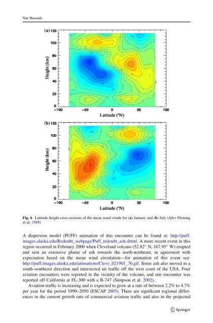
Nat HazardsFig. 6 Latitude-height cross-sections <strong>of</strong> the mean zonal winds for (a) January <strong>and</strong> (b) July (After Fleminget al. 1988)A dispersion model (PUFF) animation <strong>of</strong> this encounter can be found at: http://puff.images.alaska.edu/Redoubt_webpage/Puff_redoubt_ash.shtml. A more recent event in thisregion occurred in February 2000 when Clevel<strong>and</strong> volcano (52.82° N, 167.95° W) erupted<strong>and</strong> sent an extensive plume <strong>of</strong> ash towards the north-northeast, in agreement withexpectation based on the mean wind circulation—for animation <strong>of</strong> this event see:http://puff.images.alaska.edu/animations/Cleve_021901_76.gif. Some ash also moved in asouth–southeast direction <strong>and</strong> intersected air traffic <strong>of</strong>f the west coast <strong>of</strong> the USA. Fouraviation encounters were reported in the vicinity <strong>of</strong> the volcano, <strong>and</strong> one encounter wasreported <strong>of</strong>f California at FL-300 with a B-747 (Simpson et al. 2002).Aviation traffic is increasing <strong>and</strong> is expected to grow at a rate <strong>of</strong> between 2.2% to 4.7%per year for the period 1990–2050 (ESCAP 2005). There are significant regional differencesin the current growth rate <strong>of</strong> commercial aviation traffic <strong>and</strong> also in the projected123