Satellite detection of hazardous volcanic clouds and ... - Savaa - NILU
Satellite detection of hazardous volcanic clouds and ... - Savaa - NILU
Satellite detection of hazardous volcanic clouds and ... - Savaa - NILU

You also want an ePaper? Increase the reach of your titles
YUMPU automatically turns print PDFs into web optimized ePapers that Google loves.
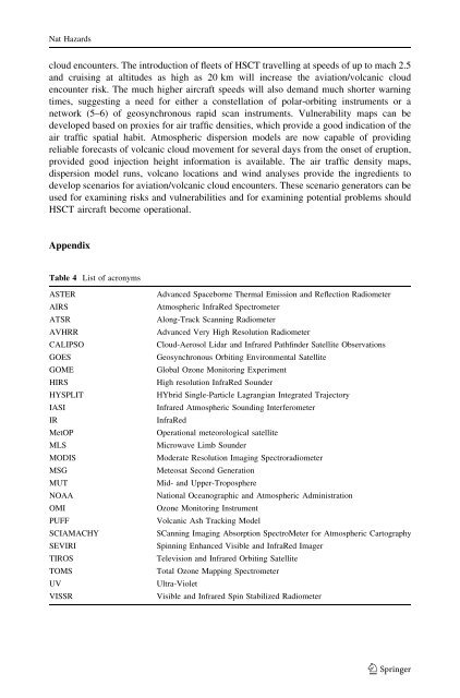
Nat Hazardscloud encounters. The introduction <strong>of</strong> fleets <strong>of</strong> HSCT travelling at speeds <strong>of</strong> up to mach 2.5<strong>and</strong> cruising at altitudes as high as 20 km will increase the aviation/<strong>volcanic</strong> cloudencounter risk. The much higher aircraft speeds will also dem<strong>and</strong> much shorter warningtimes, suggesting a need for either a constellation <strong>of</strong> polar-orbiting instruments or anetwork (5–6) <strong>of</strong> geosynchronous rapid scan instruments. Vulnerability maps can bedeveloped based on proxies for air traffic densities, which provide a good indication <strong>of</strong> theair traffic spatial habit. Atmospheric dispersion models are now capable <strong>of</strong> providingreliable forecasts <strong>of</strong> <strong>volcanic</strong> cloud movement for several days from the onset <strong>of</strong> eruption,provided good injection height information is available. The air traffic density maps,dispersion model runs, volcano locations <strong>and</strong> wind analyses provide the ingredients todevelop scenarios for aviation/<strong>volcanic</strong> cloud encounters. These scenario generators can beused for examining risks <strong>and</strong> vulnerabilities <strong>and</strong> for examining potential problems shouldHSCT aircraft become operational.AppendixTable 4 List <strong>of</strong> acronymsASTERAIRSATSRAVHRRCALIPSOGOESGOMEHIRSHYSPLITIASIIRMetOPMLSMODISMSGMUTNOAAOMIPUFFSCIAMACHYSEVIRITIROSTOMSUVVISSRAdvanced Spaceborne Thermal Emission <strong>and</strong> Reflection RadiometerAtmospheric InfraRed SpectrometerAlong-Track Scanning RadiometerAdvanced Very High Resolution RadiometerCloud-Aerosol Lidar <strong>and</strong> Infrared Pathfinder <strong>Satellite</strong> ObservationsGeosynchronous Orbiting Environmental <strong>Satellite</strong>Global Ozone Monitoring ExperimentHigh resolution InfraRed SounderHYbrid Single-Particle Lagrangian Integrated TrajectoryInfrared Atmospheric Sounding InterferometerInfraRedOperational meteorological satelliteMicrowave Limb SounderModerate Resolution Imaging SpectroradiometerMeteosat Second GenerationMid- <strong>and</strong> Upper-TroposphereNational Oceanographic <strong>and</strong> Atmospheric AdministrationOzone Monitoring InstrumentVolcanic Ash Tracking ModelSCanning Imaging Absorption SpectroMeter for Atmospheric CartographySpinning Enhanced Visible <strong>and</strong> InfraRed ImagerTelevision <strong>and</strong> Infrared Orbiting <strong>Satellite</strong>Total Ozone Mapping SpectrometerUltra-VioletVisible <strong>and</strong> Infrared Spin Stabilized Radiometer123