Satellite detection of hazardous volcanic clouds and ... - Savaa - NILU
Satellite detection of hazardous volcanic clouds and ... - Savaa - NILU
Satellite detection of hazardous volcanic clouds and ... - Savaa - NILU

Create successful ePaper yourself
Turn your PDF publications into a flip-book with our unique Google optimized e-Paper software.
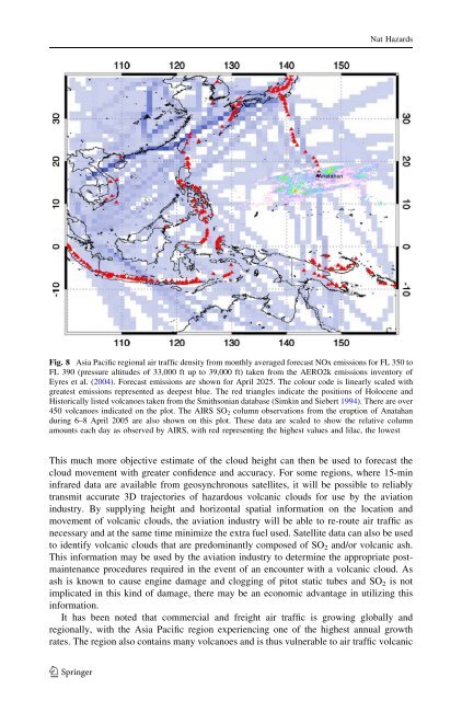
Nat HazardsFig. 8 Asia Pacific regional air traffic density from monthly averaged forecast NOx emissions for FL 350 toFL 390 (pressure altitudes <strong>of</strong> 33,000 ft up to 39,000 ft) taken from the AERO2k emissions inventory <strong>of</strong>Eyres et al. (2004). Forecast emissions are shown for April 2025. The colour code is linearly scaled withgreatest emissions represented as deepest blue. The red triangles indicate the positions <strong>of</strong> Holocene <strong>and</strong>Historically listed volcanoes taken from the Smithsonian database (Simkin <strong>and</strong> Siebert 1994). There are over450 volcanoes indicated on the plot. The AIRS SO 2 column observations from the eruption <strong>of</strong> Anatah<strong>and</strong>uring 6–8 April 2005 are also shown on this plot. These data are scaled to show the relative columnamounts each day as observed by AIRS, with red representing the highest values <strong>and</strong> lilac, the lowestThis much more objective estimate <strong>of</strong> the cloud height can then be used to forecast thecloud movement with greater confidence <strong>and</strong> accuracy. For some regions, where 15-mininfrared data are available from geosynchronous satellites, it will be possible to reliablytransmit accurate 3D trajectories <strong>of</strong> <strong>hazardous</strong> <strong>volcanic</strong> <strong>clouds</strong> for use by the aviationindustry. By supplying height <strong>and</strong> horizontal spatial information on the location <strong>and</strong>movement <strong>of</strong> <strong>volcanic</strong> <strong>clouds</strong>, the aviation industry will be able to re-route air traffic asnecessary <strong>and</strong> at the same time minimize the extra fuel used. <strong>Satellite</strong> data can also be usedto identify <strong>volcanic</strong> <strong>clouds</strong> that are predominantly composed <strong>of</strong> SO 2 <strong>and</strong>/or <strong>volcanic</strong> ash.This information may be used by the aviation industry to determine the appropriate postmaintenanceprocedures required in the event <strong>of</strong> an encounter with a <strong>volcanic</strong> cloud. Asash is known to cause engine damage <strong>and</strong> clogging <strong>of</strong> pitot static tubes <strong>and</strong> SO 2 is notimplicated in this kind <strong>of</strong> damage, there may be an economic advantage in utilizing thisinformation.It has been noted that commercial <strong>and</strong> freight air traffic is growing globally <strong>and</strong>regionally, with the Asia Pacific region experiencing one <strong>of</strong> the highest annual growthrates. The region also contains many volcanoes <strong>and</strong> is thus vulnerable to air traffic <strong>volcanic</strong>123