- Page 1 and 2: *~^J' »4V4-iu,J^MrM'*»(/>?'^* ;(l
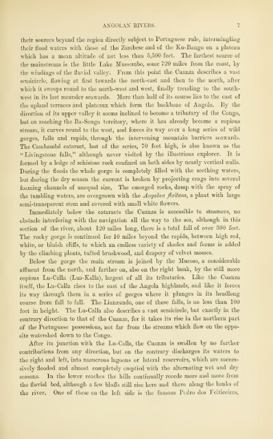
- Page 7 and 8: -fftv
- Page 9 and 10: THE EARTH AND ITSINHABITANTSTHEUNIV
- Page 11: ^1 \r. ^\CONTENTS.CHAP. ""=I. AxOOL
- Page 14 and 15: .IJST OF ILLUSTRATIONS.LIST OF ILLU
- Page 17 and 18: THE UNIVERSAL GEOGRAPHY.SOUTH AND E
- Page 19 and 20: —axCtOlan uplands. 3and separated
- Page 21 and 22: ANGOLAN UPLANDS. 5in height, the hi
- Page 26 and 27: 8 SOUTH AND EAST AFEICA.01' " Fetis
- Page 28 and 29: —10 SOUTH AND E^ST AFRICA.Climate
- Page 30 and 31: —12 SOUTH AND EAST AFEICA.siderab
- Page 32 and 33: 14 SOUTH AXD EAST AFEICA.from nortl
- Page 34: IGSOUTn AND EAST AFEICA.extremoly d
- Page 38 and 39: 18 SOUTH AND EAST AFEICA.by tho Cab
- Page 40 and 41: 20 SOTTTIT AXD EAST AFRICA.TjikBlnu
- Page 42 and 43: 22 SOUTH AND EAST AFRICA.Tlio Bunda
- Page 44: ^1SOUTU AND EAST APEICA.TiiiiGaxgi^
- Page 48 and 49: 26 SOUTH AND EAST AFEICA,dangerous
- Page 50 and 51: 28 SOUTH AND EAST AFEICA.brought iu
- Page 52 and 53: 80 SOUTH AND EAST AFRICA.settlement
- Page 54 and 55: 82 SOrXII AXD EAST AFEICA.no busy t
- Page 56 and 57: —»t SOUTH AND EAJ^T AFETCA.The n
- Page 58 and 59: 36 SOUTH AND EAST AFEICA.each. From
- Page 60: S8SOUTH AND EAST AFEICA.direction f
- Page 64 and 65: 40 SOUTH AND EAST AFEICA.from suppl
- Page 66 and 67: —42 SOUTH AND EAST AFRICA.foot of
- Page 68 and 69: 44 SOUTH iWD EAST AFRICA.exlensivo
- Page 70 and 71: 46 SOUTH AND EAJ^T AFEICA.place. Be
- Page 72 and 73: 48 SOUTH AND EAST AFEICA.rainy seas
- Page 74:
60 SOUTH AND EAST AFRICA.Dombe-Pequ
- Page 78 and 79:
52 SOUin AST) EAST AFEICA.Ttc Cunen
- Page 80 and 81:
54 SOUTH AND EAST AFRICA.G(tmhos an
- Page 82 and 83:
36 SOUTH AND EAST AFRICA.Angola is
- Page 84 and 85:
58 SOUTH AND EAST AFEIOA.with tliot
- Page 86 and 87:
Cnx\.PTEIl II.DAIMAEA AND NAMAQUA L
- Page 88 and 89:
;C2SOUTH AND EAST APEICA.exploratio
- Page 90:
G-iSOUTH AND EAST AFRICA.shore stre
- Page 94 and 95:
66 SOUTH AND EAST AFRICA.later dire
- Page 96 and 97:
G3SOUTK AND EAST AFRICA.Of all the
- Page 98 and 99:
—70 ROUTn AND EAST AFEICA.Ilcrero
- Page 100 and 101:
72 SOUTH AND EAST AFEICA.The chiefs
- Page 102 and 103:
74 SOUTH AND EAST AFRICA.twentj' th
- Page 104:
—SOUTH AND EAST AFRICA.in the nei
- Page 108 and 109:
CIIAITEIl III.SOUTH AFEICA.rilYSICA
- Page 110:
—80 SOUTH AND EAST ATItlCA.evei-l
- Page 115 and 116:
MOUNTAINS OF SOUTH AUEICA. 81rapid
- Page 119 and 120:
THE KAEEOOS. 83points by the coast
- Page 121 and 122:
THE DEAKEXBERG. 65chief summits of
- Page 123 and 124:
THE ORANGE EIVER. 87house than from
- Page 125 and 126:
THE OEAXGE EIYER. 89unable to compl
- Page 127 and 128:
THE GEEAT FISH HIYER. 91gorges, is
- Page 129 and 130:
L.IKE ST. LUCLi. 98I^assati, the ch
- Page 131:
i0",
- Page 134 and 135:
;96 SOUTH AND EAST AFRICA.ropubllos
- Page 136 and 137:
98 SOUTU .VXD EAST AFRICA.Except at
- Page 138 and 139:
—100 SOUTH AND KAST AFKICA.missio
- Page 140 and 141:
102 SOT^TII AND EAST AFRICA.tlio ii
- Page 142 and 143:
104 SOUTH AND EAST AFIiTCA.groups,
- Page 144 and 145:
100 SOUTH AND EAST AFEICA.liya'iia,
- Page 146:
103 SOUTH AXD EAST AFRICA.gradually
- Page 150 and 151:
110 SOUTH AXI) EAST AFEICA.men;yet
- Page 152 and 153:
11-2 SOUTH AND EAST AFIilf'A.animal
- Page 154 and 155:
,The114 POUTir AND EAST AFRICA.clos
- Page 156 and 157:
U(\SOUTH AND EAST AFETCA.claimed by
- Page 158:
CIIArTER IV.CAPE COLONY AND ITS DEP
- Page 161:
CAPESnoo,n.K.,,..iJr:.^^^^^Rvnevdd'
- Page 164 and 165:
120 SOUTH AND EAST AFRICA.origin ha
- Page 166 and 167:
122 SOUTU AND EAST AFRICA.(lers, th
- Page 168 and 169:
12iSOUTH AND EAST AFRICA.The territ
- Page 170 and 171:
, 3,300126 SOUTH AXP EAST AFRICA.th
- Page 173 and 174:
CAPE TOVrS. 127mented by a canal li
- Page 175 and 176:
SALPAXHuV BAY. 129this basin that V
- Page 177 and 178:
BEAUFOET WEST. 181situated on the l
- Page 179 and 180:
POHT ELIZ.y3ETH. 133of Table Bay. F
- Page 183 and 184:
OET .VLFEED.—FOET BEAUFOET. 186ti
- Page 185 and 186:
COLESBUEG.—HOPETOWX. 187year 1888
- Page 187 and 188:
nXICUI/rUEE.—STOCK-lfflEEI>IXG. 1
- Page 189 and 190:
O^iTETOn-FATimNn.— lEBTCATTON. ]
- Page 191 and 192:
TBAPE OF CAPE roi,OXY. 143The colon
- Page 195 and 196:
ADMINISTRATION OP C.iPE COLONY. 145
- Page 197 and 198:
GEIQUiVL-US^D T\T2ST. 147religious
- Page 199 and 200:
THE GEIQUAS. 149tions occur in the
- Page 201 and 202:
THE GRIQU.\I.AND DLUIOXD FIELDS. 15
- Page 203:
:-:.^ft^P5c^ m:
- Page 206 and 207:
154 SOUTH AND EAST AFRICA.it M-as a
- Page 208 and 209:
166 Sni'Tn AND EAST AFniCA.BErilUAN
- Page 210 and 211:
168 SOUTU AND EAST .U'^EICA.The Bcc
- Page 212 and 213:
160 SOUTH AND EAST AFRICA.and which
- Page 214:
162 SOUTH AXI) KAi^T Al'RTOA.to the
- Page 218 and 219:
—lC>i SOTTTII AXn I'^ART AFRICA.a
- Page 220 and 221:
100 SOUTH AND EAST AFRICA." liucl P
- Page 222 and 223:
;1G8SOUTH AND EAST AFRICA.repulsed.
- Page 224 and 225:
170 SOUTH AND l^AST AFRICA.town in
- Page 226 and 227:
;172 SOUTH AND EAST AFRICA.llie wli
- Page 229 and 230:
THE FINGOS. 173All Europeans who ha
- Page 231 and 232:
TEMBULAXD. 175hindi-ancc. lu fact,
- Page 233 and 234:
GEIQr.\I.AND EAST. 177The surface o
- Page 237 and 238:
NATAL. 179But Dingaan, king of the
- Page 239 and 240:
NATIVES OF NATAL. 181for the Kafir
- Page 241 and 242:
EESOUBCES OF XATAL. 183plaiu of the
- Page 245 and 246:
TUl'UGKAPKY OF XATAL. 185planned fo
- Page 247 and 248:
DUEBAN. 187of tlic ebb tides, thus
- Page 249 and 250:
ADMINISTRATION OF NATAL. 189surface
- Page 251 and 252:
ZULLXAXD. 191the Boers descending f
- Page 253 and 254:
AMATONGALAND. 193now these warlike
- Page 255 and 256:
SWAZU..VND. 105The Amaswazi people,
- Page 257 and 258:
TIIE ORAXGE FEEE :>TATE. 197stitute
- Page 259 and 260:
THE ORAXGE FREE STATE. 199lilies in
- Page 261 and 262:
TRANSVAAL. 201quit-rents, stamps, a
- Page 263 and 264:
TEANSVAAL. 203and thus was grailuai
- Page 265 and 266:
TR.\N.SVAAL. 205described as " baib
- Page 267:
*.^
- Page 270 and 271:
—208 SOUTH AND EAST AFIUCA.liir};
- Page 272 and 273:
—210 SOUTU AXD EAST AFRICA.which
- Page 274:
212 SOUTH AND EAST AFEICA.entirclj'
- Page 278 and 279:
• Marvin, np. cil., p. 17. ,214 S
- Page 280 and 281:
21GSOUTH AND EAST AFRICA.charge on
- Page 282 and 283:
—218 SOUTU AND EAST AFRICA.chiiii
- Page 284 and 285:
220 SOUTU AND EAST AFlUfA.spirits t
- Page 286 and 287:
2-22 SOUTU AXD EAST AFRICA.not al)n
- Page 288 and 289:
224 SOUTH AND KAST AFRICA.niif^ht b
- Page 290 and 291:
226 SOUin AND EAST AFEICA.districts
- Page 293 and 294:
INHABITANTS OF GAZALAND. 227the bui
- Page 295 and 296:
INHABITANTS OF GAZ.VLAND. 229whom t
- Page 297 and 298:
XOPOGEArUY OF GAZAL.'^'i'. 281liar
- Page 299 and 300:
TOrOGEAPIIY 01' GAZALAXD. 233sky wa
- Page 301 and 302:
CHAPTER YIII.ZAMBESE AXD KL'-BAXGO
- Page 303 and 304:
THE Kl'-BANGO BASIX. 237sources wit
- Page 305 and 306:
LAKE NGAMT. 239The Tonke (Tonka, Ti
- Page 307 and 308:
THE CHOBE BTTER. 2414,500 feet abov
- Page 311 and 312:
TUE N-ieXOlUA F.VLLS.iVdcliffs, whi
- Page 313 and 314:
THE MIDDLE ZAMBESE. 245others assum
- Page 315 and 316:
LAKE NYASSA. 247the binding effects
- Page 319 and 320:
LAKE NYASSA. 249suffice to traverse
- Page 321 and 322:
THE LO^T.I! ZAMBESE. 251giiese, thr
- Page 323 and 324:
THE ZAMBESE DELTA. 253inundations.
- Page 325 and 326:
FAUNA OF TIIK Z.\J»03ESE BASIN. 25
- Page 327:
BAROTSE TYPES.
- Page 330 and 331:
258 SOUTH AND EAST AFKICA.before th
- Page 332 and 333:
2G0SOUTU AND EAST AFKlt'A.residence
- Page 334 and 335:
;2r.'2 fjorni axd f.ast ArriTOA.the
- Page 336:
201 porTir Axn east afrtca.also des
- Page 340 and 341:
26CPOrTIT AXn EAST AVnirA.having be
- Page 342 and 343:
268 SOfTTl AM> KASiT Al'RHA.torriir
- Page 344 and 345:
•210 ^urXll AXU KAST Al"l!liA.rou
- Page 346 and 347:
'11-1 SOL' I'll Axi> i:ast Al'iaCA.
- Page 348 and 349:
iJ74SOUTH AND KAST AFRICA.clear tli
- Page 350 and 351:
—'Scale276 SOUTH AND EAST AFRICA.
- Page 352 and 353:
27ft sm-i'ii Axn ivVST avrtcv.iiian
- Page 354 and 355:
28n SOl'TII AX1> EAST AVRTOA.Litiil
- Page 356 and 357:
282 SOrTII A\]J EAST AFRICA.ports b
- Page 358 and 359:
2R1 SOfTII AM' KAST Al'RTf'A.yit tl
- Page 360:
28G SOrill AMI i;AsT AFinCA.perhaps
- Page 364 and 365:
—288 ?;OrTII AXIi EAST AFRICA.dee
- Page 366 and 367:
—290 SOUTH AND EAST AFRICA.lours
- Page 368 and 369:
'2'J2 .l' rlilcis, wlio are seated
- Page 370 and 371:
201 SOTTTrT ANT) KAST AFRICA.incurs
- Page 372 and 373:
200 sol 'Til AM' i;ast Al'inOA.Avii
- Page 374 and 375:
298 SOin-TI AND EAf^T AFRICA.of ric
- Page 376 and 377:
;800 SOITII AMI i;.\ST AITJCA.Ices
- Page 378 and 379:
—802 SOUTH AND EAST AFRICA.'J2,{.
- Page 380:
804 SOUTH AND KAST Al'KK'A.l'll^^I(
- Page 383:
DB ACAMOYO.1 Totiaxhotooi -J:IfM f^
- Page 386 and 387:
SOGSOUTH AND EAST .APEIOA.as is evi
- Page 388 and 389:
308 SOUTH AND EAST APRICA.iKisin, c
- Page 390 and 391:
310 SOUTH AND EAST AFEICA.frrowtli
- Page 392 and 393:
812 SOl'TII AXn KAST AFRICA.of a fo
- Page 394:
314 SOUTH AND 1L\BT AFRICA.The Wu/c
- Page 398 and 399:
81(5 SOUTH A\I» KAST AFlilCA.Persi
- Page 400:
818 SOUTH AND EAST AFRICA.Yaos, who
- Page 404 and 405:
820 SOUTH AND EAST AFRIPA.inhabitan
- Page 406 and 407:
822 SOUTH AND KART Al'RTfA.the zone
- Page 408 and 409:
824 SOUTH -VXD EAST AFRICA.interior
- Page 410 and 411:
3'26 SOUTH AND EXiiT AFRICA.The chi
- Page 412 and 413:
—328 SOUTn AND EAST AFRICA.adjace
- Page 415 and 416:
ISLAND OF ZAXZIBAE. 829rather to ex
- Page 417 and 418:
ISLAND OF ZANZIBAR. 881The American
- Page 419 and 420:
ISLAND OF PEMBA. 333ToroCJRAPIIY.Th
- Page 421 and 422:
ADMIXISTRATIOX OF ZANZIBAR. 335Arab
- Page 423 and 424:
MASM LAXP. 837Doubtless all these a
- Page 425 and 426:
VOLCAXOES. 339till- roll of distant
- Page 427 and 428:
L.AJvE BARIXGO. 341Mountaiu " nearl
- Page 429 and 430:
USAMBAEA JklOUNTArNS.348lagoon. Thi
- Page 431 and 432:
KILIMA-yjAHO. 345Kutneroons liv abo
- Page 433 and 434:
hloatiiigKILIMA-NJAKO. 347luy other
- Page 435 and 436:
MOUNT ELGON. 349conditions are muel
- Page 437 and 438:
TUE TAXA lUVER. 851Two other hirgc
- Page 439 and 440:
FAUNA OF iLVSAI LAND. 853aspect, bu
- Page 441 and 442:
THE -WASAMBARAS. 355all these inlan
- Page 443 and 444:
THE WACHAGAS. 357Tn general the inh
- Page 445 and 446:
THE WANTIKAS. 359North of the Panga
- Page 447 and 448:
THE WAPOKOMOS. 361The Wafokomos and
- Page 449 and 450:
THE WAKWAFI. 868Besides the Bantus,
- Page 451 and 452:
THE JfASAI. 865their beds. No negot
- Page 453 and 454:
THE MASAI. 867disposed above the he
- Page 457 and 458:
THE GALLAS.8G9forefathers pass into
- Page 459 and 460:
MOMBAZ. 871Momhaz, the Mombasa of t
- Page 461 and 462:
M03IBAZ. 873porters. Consequently t
- Page 463 and 464:
THE EAST AFEIC.VN ASSOCIATION. 375I
- Page 465 and 466:
CHAPTER XTI.SOMALI AND EAST GALLA L
- Page 467 and 468:
PHYSICAL FEATUEES OP SOMALI LAND. 3
- Page 469 and 470:
CAPE GUAEDAFUI.S81coast range draws
- Page 471 and 472:
ER'EES OF SOMALI LAXD. 888the ravin
- Page 473 and 474:
THE JTJBA RITER. 885equator. Tn thi
- Page 475 and 476:
THE WEBI RH'EE. 887beach, shoals, a
- Page 477 and 478:
FAUXA OF SO^^ALI LAND. 389wide spac
- Page 479 and 480:
lyHABIT.VyTS OF S03IAL1 LAND.39IAfr
- Page 483 and 484:
THE SOMALI RACE. 393in tlie directi
- Page 485 and 486:
THE SOMAIJ RACE. 895providing thems
- Page 487 and 488:
POMALI TEIBE^. 897from pasturage to
- Page 489 and 490:
SOXLALI TRIBES. 399In still greater
- Page 491:
GALLA TVl'KhS
- Page 494 and 495:
102 SOUTU AND KAST AFRICA.sacred ch
- Page 496 and 497:
404 SOUTH AND KAST AFRICA.ihom tlie
- Page 498 and 499:
•lOGSOUTH AN'D EAST AFRICA.\\'iih
- Page 500 and 501:
•108SOUTH AND EAST AFRICA.all Uio
- Page 502 and 503:
Ill)SOUTH AND KAST AFRICA.which, af
- Page 504 and 505:
—412 SOUTH AND KAST AFRICA.Aden i
- Page 507 and 508:
MAVKT.—HKHBERA. 418tradition, her
- Page 509 and 510:
GEXEHAI. KEFLECTIOXS. 415land and i
- Page 511 and 512:
MADAGASCAE. 423last completely wast
- Page 515:
M ADAOAbUAFCHanu.jCiMh.,L:,U, il
- Page 518 and 519:
42GSOL'TH AND EAST AFEICA.ns leaseh
- Page 520 and 521:
"418 SOUTH AND EAST AFRICA.the isla
- Page 522 and 523:
—120 SOUTH AND EAST AFRICA.Sultan
- Page 524 and 525:
422 SOTTTn AN'D EAST AFEICA.hood of
- Page 526 and 527:
423 SOUTH AND EAST AFRICA.On the we
- Page 528 and 529:
—130 SOUTH AND KAST AFRICA.dispos
- Page 530:
•132 SOUTH AND EAST AFRICA.On tho
- Page 533 and 534:
• Winter and summer temperatures
- Page 535 and 536:
FLORA OF M^\.DAOASCAR. 435weslern s
- Page 537 and 538:
FAUNA OF MADAUASCAE. 437an essentia
- Page 539 and 540:
INHABITANTS OF MADAGASCAR. 439aston
- Page 541 and 542:
THE nOVAS. 441of chiefs claim this
- Page 543 and 544:
THE HOVAS.44BAccording to Grandidie
- Page 545 and 546:
THE BET^ILEO AND BARA TRIBES. 446Th
- Page 547 and 548:
TIIE g^lLLVXAKAS AXD KIMOS. 447Mala
- Page 549 and 550:
MALAGASY CUSTOMS. 449districts of t
- Page 551 and 552:
M.'U.AGASY CUSTOMS. 451attended to
- Page 553 and 554:
PBOGRESS OF MADAGASCAB. 453cultivat
- Page 555 and 556:
PROGRESS OF MADAGASCAR. 450veiiitut
- Page 559 and 560:
TOPOGRAPnT OV MADAGASCVK. 45715ut b
- Page 561 and 562:
TOPOGRAPHY OF MADAGASCAR. 459approa
- Page 565 and 566:
TOPOGRAPHY OF JiL^DAGASC.VE.4r,lPor
- Page 567 and 568:
TOPOGRAPUY OF M-UJAG-AJsCAR.46Sof t
- Page 569 and 570:
AKMIXI.STRATIOX OF MADAGASCAR. 465W
- Page 571 and 572:
TUE COMORO ISLANDS.4G7about, the wh
- Page 575 and 576:
THE COMORO ISLANDS.HidThe Comoro or
- Page 577 and 578:
THE SEYCHELLES. 471A geographical d
- Page 579 and 580:
THE SEYCHFJJ.es.iTSThe fauna of the
- Page 581 and 582:
i.APPENDIX.STATISTICALTABLES.ANGOLA
- Page 583 and 584:
APPENDIX. 477DAMAEA AND NAMAQUA LAN
- Page 585 and 586:
APPENDIX. 479Total area unJer culti
- Page 587 and 588:
APPENDIX. 481CHIEF TBIBAL DmSIONS I
- Page 590 and 591:
IofI! Ama-Ntombcla,;484 APPENDIX.EA
- Page 592 and 593:
486 APPENDIX.ArrEOXIJ[ATE rorULATIO
- Page 594 and 595:
488 APPENDIX.Ki-Teti-iGwa-Tevi } ne
- Page 596 and 597:
;490 APPENDIX.Maowanowaka north-eas
- Page 598 and 599:
..IKosova,Arusha,'Matumhato,—.'49
- Page 600 and 601:
'iIi494 AITENKLX.Protestuutu (1886)
- Page 602 and 603:
496 APPKXDIX.Maii.utsu, in Muyottc.
- Page 604 and 605:
14.108 iM>,i-;.\IIhiuIxi, 17Hainpii
- Page 606 and 607:
3500 INDEX.Iljioiigo Mountain, 1 1
- Page 608 and 609:
602 INDEX.NojfTDuM in Madagascar, l
- Page 610:
1'501 IX HEX.Wii-Kiimbn, 301AVa-K:i


![The Philosophy of Progress [pdf]](https://img.yumpu.com/14077359/1/190x245/the-philosophy-of-progress-pdf.jpg?quality=85)