KU_Chapter01_DataCollection_2014-06-10
KU_Chapter01_DataCollection_2014-06-10.pdf
KU_Chapter01_DataCollection_2014-06-10.pdf
- No tags were found...

Create successful ePaper yourself
Turn your PDF publications into a flip-book with our unique Google optimized e-Paper software.
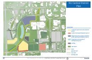
CAMPUS STRUCTURE<br />
Even with <strong>KU</strong>’s defining ridge and valley landforms,<br />
there is an informal integration between<br />
the campus and the small town urban street grid<br />
on the north and east campus edges. The city of<br />
Lawrence grew outward from downtown and the<br />
river to meet the campus at the top of the hill at<br />
Oread Avenue. To the north, the city lies beyond<br />
the stadium in the valley.<br />
The campus has grown considerably beyond the<br />
ridge, down the slope, onto the plain to the south,<br />
and across to Daisy Hill to the west. Campus<br />
growth over time, to the south and west, parallels<br />
that of Lawrence. Land availability was the<br />
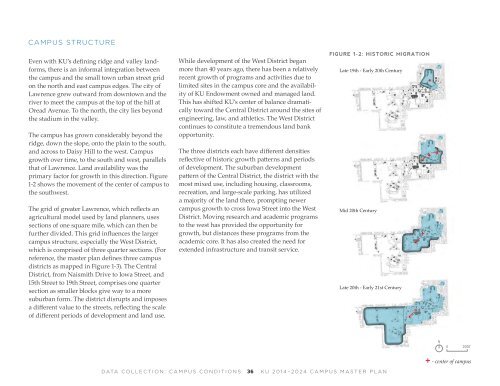
primary factor for growth in this direction. Figure<br />
1-2 shows the movement of the center of campus to<br />
the southwest.<br />
The grid of greater Lawrence, which reflects an<br />
agricultural model used by land planners, uses<br />
sections of one square mile, which can then be<br />
further divided. This grid influences the larger<br />
campus structure, especially the West District,<br />
which is comprised of three quarter sections. (For<br />
reference, the master plan defines three campus<br />
districts as mapped in Figure 1-3). The Central<br />
District, from Naismith Drive to Iowa Street, and<br />
15th Street to 19th Street, comprises one quarter<br />
section as smaller blocks give way to a more<br />
suburban form. The district disrupts and imposes<br />
a different value to the streets, reflecting the scale<br />
of different periods of development and land use.<br />
While development of the West District began<br />
more than 40 years ago, there has been a relatively<br />
recent growth of programs and activities due to<br />
limited sites in the campus core and the availability<br />
of <strong>KU</strong> Endowment owned and managed land.<br />
This has shifted <strong>KU</strong>’s center of balance dramatically<br />
toward the Central District around the sites of<br />
engineering, law, and athletics. The West District<br />
continues to constitute a tremendous land bank<br />
opportunity.<br />
The three districts each have different densities<br />
reflective of historic growth patterns and periods<br />
of development. The suburban development<br />
pattern of the Central District, the district with the<br />
most mixed use, including housing, classrooms,<br />
recreation, and large-scale parking, has utilized<br />
a majority of the land there, prompting newer<br />
campus growth to cross Iowa Street into the West<br />
District. Moving research and academic programs<br />
to the west has provided the opportunity for<br />
growth, but distances these programs from the<br />
academic core. It has also created the need for<br />
extended infrastructure and transit service.<br />
FIGURE 1-2: HISTORIC MIGRATION<br />
Late 19th - Early 20th Century<br />
Mid 20th Century<br />
Late 20th - Early 21st Century<br />
N<br />
0 2000’<br />
+ - center of campus<br />
DATA COLLECTION: CAMPUS CONDITIONS<br />
36<br />
<strong>KU</strong> <strong>2014</strong>–2024 CAMPUS MASTER PLAN