KU_Chapter01_DataCollection_2014-06-10
KU_Chapter01_DataCollection_2014-06-10.pdf
KU_Chapter01_DataCollection_2014-06-10.pdf
- No tags were found...

Create successful ePaper yourself
Turn your PDF publications into a flip-book with our unique Google optimized e-Paper software.
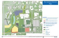
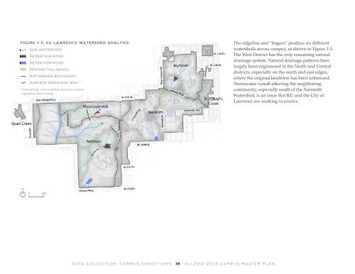
FIGURE 1-5; <strong>KU</strong> LAWRENCE WATERSHED ANALYSIS<br />
SUB-WATERSHED<br />
RETENTION POND<br />
DETENTION POND<br />
PRAIRIE/TALLGRASS<br />
WATERSHED BOUNDARY<br />
SURFACE DRAINAGE WAY *<br />
* Generalized, representation based on contour<br />
signatures from survey<br />
The ridgeline and “fingers” produce six different<br />
watersheds across campus, as shown in Figure 1-5.<br />
The West District has the only remaining natural<br />
drainage system. Natural drainage patterns have<br />
largely been engineered in the North and Central<br />
districts, especially on the north and east edges,<br />
where the original landform has been urbanized.<br />
Stormwater runoff affecting the neighboring<br />
community, especially south of the Naismith<br />
Watershed, is an issue that <strong>KU</strong> and the City of<br />
Lawrence are working to resolve.<br />
N<br />
0 900’<br />
DATA COLLECTION: CAMPUS CONDITIONS<br />
39<br />
<strong>KU</strong> <strong>2014</strong>–2024 CAMPUS MASTER PLAN