KU_Chapter01_DataCollection_2014-06-10
KU_Chapter01_DataCollection_2014-06-10.pdf
KU_Chapter01_DataCollection_2014-06-10.pdf
- No tags were found...

You also want an ePaper? Increase the reach of your titles
YUMPU automatically turns print PDFs into web optimized ePapers that Google loves.
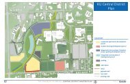
Support functions are mostly sited appropriately<br />
in perimeter locations. Large surface parking<br />
areas, defined as support, are situated adjacent to<br />
campus access points. Clear pathways connecting<br />
parking to the academic/research areas have been<br />
established, but are not fully accessible.<br />
New campus access points have developed as<br />
the campus has grown to the south and west.<br />
Historic campus gateways, such as the Chi Omega<br />
Fountain entrance, are still considered iconic<br />
gateways. However, important new gateway<br />
conditions occur at 15th Street and Iowa Street, and<br />
19th Street and Iowa Street. The most developed<br />
arrival sequence is along Naismith Drive, north<br />
of 19th Street to Sunnyside Avenue. West District<br />
boundaries are much clearer, as they coincide<br />
either with major city roadways or woodlands.<br />
Though the Central and West districts are<br />
separated only by Iowa Street, a U.S. highway cut<br />
through the ridge, this condition makes the two<br />
feel disconnected, despite being contiguous. The<br />
West District contributes to the overall functional<br />
needs of <strong>KU</strong> as a land resource for programs<br />
that could not be sited in the campus core. Many<br />
programs sited in the West District were chosen<br />
because they operate somewhat independently. For<br />
example, <strong>KU</strong> Endowment, Lied Center, and the<br />
Robert J. Dole Institute of Politics are a few of the<br />
major occupants.<br />
West District is comprised of three quarter sections,<br />
which are connected to the Central District<br />
along Iowa Street between Bob Billings Parkway<br />
and 19th Street. Most development has occurred<br />
along the eastern edge at Iowa Street containing<br />
academic/research, outreach, support, and<br />
recreation uses. Support uses also occur along Bob<br />
Billings and the Yankee Tank Creek. Approaches<br />
to campus from the west and south are increasingly<br />
important, driven by Lawrence’s growth and<br />
extended regional roadway improvements.<br />
Open space in the North and Central districts<br />
is amassed on the hillside sloping to Memorial<br />
Stadium. Potter Lake, Marvin Grove, and the<br />
Campanile provide an inward park-like perspective<br />
contrasted with the Mount Oread ridge, which<br />
provides exceptional encompassing views to the<br />
horizon. The vistas in and out give a strong sense<br />
of visual space to the campus. With the exception<br />
of some favorite lawn areas, such as that in front<br />
of Strong Hall, there is a notable absence of classic<br />
collegiate quadrangle and interstitial space, as it is<br />
difficult to develop on the steeper slopes. The lawn<br />
area between Jayhawk Boulevard and Sunnyside<br />
Avenue lacks a coherent spatial network, but<br />
presents an opportunity for better defined and<br />
usable open spaces. There are great front lawns<br />
and more formalized civic open spaces associated<br />
with landmark buildings, such as Fraser Hall and<br />
Allen Fieldhouse. There are other smaller spaces,<br />
such as Mississippi Terrace and Prairie Acre, that<br />
contribute to a more personally scaled social realm.<br />
The West District has significant amounts of<br />
undeveloped open space, as well as the legacy<br />
Pioneer Cemetery near the Irving Hill Road<br />
overpass. Hilltop and hillside development patterns,<br />
with natural drainage and forested slopes,<br />
present a pleasing aesthetic and an opportunity to<br />
reinforce naturalistic environments. These stand<br />
in significant contrast to large fields of parking at<br />
the Lied Center and the Park & Ride facility at the<br />
north and south ends of the district. Every effort<br />
needs to be made to develop the remainder of<br />
this land with respect for the natural land form,<br />
sustainable development, and drainage patterns.<br />
DATA COLLECTION: CAMPUS CONDITIONS<br />
43<br />
<strong>KU</strong> <strong>2014</strong>–2024 CAMPUS MASTER PLAN