Times of the Islands Summer 2016
Presents the "soul of the Turks & Caicos Islands" with in-depth features about local people, culture, history, environment, businesses, resorts, restaurants and activities.
Presents the "soul of the Turks & Caicos Islands" with in-depth features about local people, culture, history, environment, businesses, resorts, restaurants and activities.

You also want an ePaper? Increase the reach of your titles
YUMPU automatically turns print PDFs into web optimized ePapers that Google loves.
green pages newsletter <strong>of</strong> <strong>the</strong> department <strong>of</strong> environment & maritime affairs<br />
water <strong>of</strong> <strong>the</strong> freshwater lens<br />
by diffuse flow to <strong>the</strong> coast is<br />
unable to conduct water efficiently.<br />
Tubular cave conduits<br />
develop, much like water pipes,<br />
to carry <strong>the</strong> flow. These tubes<br />
can be quite large, up to 10<br />
m (33 ft) or more in diameter.<br />
They can become large enough<br />
that <strong>the</strong>ir ro<strong>of</strong>s become unstable<br />
at certain locations, and<br />
collapse occurs. This collapse<br />
can work its way upward until<br />
it breaches <strong>the</strong> surface <strong>of</strong> <strong>the</strong><br />
bank. When sea level rises at <strong>the</strong><br />
end <strong>of</strong> a glaciation, <strong>the</strong>se collapses<br />
become flooded to form<br />
blue holes. Cave divers can go<br />
into <strong>the</strong>se blue holes, and sometimes<br />
are able to enter <strong>the</strong> large,<br />
horizontal caves that developed<br />
during a lower sea level.<br />
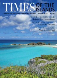
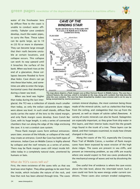
The map above depicts a flank margin cave at Blue Horizon Resort in Middle Caicos. The cave has a<br />
cultural feature, <strong>the</strong> stairway, which is included on <strong>the</strong> map, along with symbols that help describe<br />
When sea level was higher what <strong>the</strong> cave contains. The cave has been breached by modern wave erosion and is on its way to<br />
being overprinted by marine processes.<br />
than today during <strong>the</strong> last interglacial,<br />
<strong>the</strong> TCI was a collection <strong>of</strong> islands much smaller contain mineral displays, <strong>the</strong> most common being those<br />
than today, as only <strong>the</strong> eolian calcarenite dune ridges made <strong>of</strong> <strong>the</strong> mineral calcite, such as stalactites that hang<br />
were above sea level. In such small islands, diffuse flow from <strong>the</strong> ceiling, and stalagmites that rise up from <strong>the</strong><br />
easily carries <strong>the</strong> water <strong>of</strong> <strong>the</strong> lens to <strong>the</strong> island margin, ground, as well as slopes <strong>of</strong> calcite called flowstone. A<br />
and only flank margin caves develop. Even Conch Bar variety <strong>of</strong> exotic minerals can also be found. Stalagmites<br />
Cave, with its huge length, is only a series <strong>of</strong> connected are especially important, as <strong>the</strong>y grow from drip water in<br />
chambers that run along <strong>the</strong> edge <strong>of</strong> <strong>the</strong> ridge enclosing thin layers, and <strong>the</strong>ir interior looks much like <strong>the</strong> growth<br />
<strong>the</strong> cave; it is not a conduit cave system.<br />
rings found in <strong>the</strong> trunk <strong>of</strong> a tree. These layers can be<br />
These flank margin caves form without entrances; dated, and <strong>the</strong>ir isotopes examined, to study how climate<br />
years later, erosion <strong>of</strong> <strong>the</strong> hillside, or collapse <strong>of</strong> <strong>the</strong> ro<strong>of</strong>, changed in <strong>the</strong> past.<br />
may create an entrance. Conch Bar Cave has both types <strong>of</strong> Along <strong>the</strong> coasts <strong>of</strong> <strong>the</strong> TCI, especially <strong>the</strong> Crossing<br />
entrances. Indian Cave on Middle Caicos is highly altered Place Trail <strong>of</strong> Middle Caicos, a number <strong>of</strong> flank margin<br />
by collapse and <strong>the</strong> ro<strong>of</strong> remains as a series <strong>of</strong> arches. caves have been exposed by wave erosion <strong>of</strong> <strong>the</strong> high<br />
There may be flank margin caves still intact inside hillsides<br />
today in a completely natural state, unentered by present an interesting problem, as sea cliffs are exactly<br />
dune ridges. The caves are present in sea cliffs, and<br />
humans or bats.<br />
where one would expect to find sea caves produced by<br />
<strong>the</strong> mechanical energy <strong>of</strong> waves and not by dissolving <strong>the</strong><br />
What do TCI’s caves tell us?<br />
rock.<br />
First, <strong>the</strong> mere existence <strong>of</strong> <strong>the</strong> caves tells us that sea One useful line <strong>of</strong> evidence is where <strong>the</strong> cave exists<br />
level was once higher. They allow geology to be seen from above <strong>the</strong> tide level, above <strong>the</strong> intertidal notch. Such a<br />
<strong>the</strong> inside, which includes <strong>the</strong> nature <strong>of</strong> <strong>the</strong> rock, and cave could not form by wave energy under current conditions.<br />
These caves also contain eroded how that rock has been altered through time. The caves<br />
stalagmites,<br />
24 www.timespub.tc