
Create successful ePaper yourself
Turn your PDF publications into a flip-book with our unique Google optimized e-Paper software.
GLOBAL INVESTOR 2.07 Enrichment — 35<br />
the Arctic.” The key impediment preventing ships from traversing<br />
the North west Passage has always been ice. Floating ice or icebergs<br />
can bring hazards for ships, as it did for the Titanic. The<br />
Northwest Passage is a sea route connecting the Atlantic and Pacific<br />
Oceans through the Arctic Archipelago of northern Canada<br />
and along the northern coast of Alaska, USA (Figure 5). It extends<br />
from Baffin Bay (situated between West Greenland and Baffin<br />
Island) to the Bering Strait (Figure 5).<br />
In the 16th century, the idea of traveling to China and India by<br />
sailing across the North Pole became increasingly popular. Ever<br />
since then, explorers have been searching for the Arctic grail,<br />
a “shortcut” from Europe to East Asia through the American continent.<br />
The existence of such a shortcut route was proven in the early<br />
19th century, but it was not navigated until 1903, when the Norwegian<br />
explorer, Mr. Roald Amundsen, successfully traversed the<br />
Northwest Passage in a 3-year voyage.<br />
Considerable time and cost advantages<br />
Throughout maritime history, the Northwest Passage has promised<br />
a potential oceanic bridge that could link the trading fortunes of<br />
Europe and East Asia. Marine transportation companies are aware<br />
that, if navigable, widespread use of the Northwest Passage would<br />
enhance <strong>global</strong> trade this century. Traveling along the Northwest<br />
Passage would effectively reduce the mileage distance required to<br />
move goods between the largest trading blocks in the world by<br />
almos t half, meaning less shipping time, less manpower, fewer labor<br />
hours and lower maintenance and other time-sensitive variables<br />
in marine transportation. The mileage advantages of the Northwest<br />
Passage are shown in Figure 4 and suggest that the potential savings<br />
offered by the Northwest Passage route are considerable. A<br />
Hamburg (Germany) to Vancouver (Canada) voyage via the Northwest<br />
Passage rather than through the second most attractive<br />
alterna tive, the Panama Canal, would entail a huge 24% savings in<br />
nautic al miles. The Hamburg-to-Yokohama trip is more than 4,000<br />
nautical miles, or 38%, shorter than the current Suez Canal route.<br />
With fuel costs ever increasing and the paramount importance of<br />
supply chain timing and coordination for economic growth in today’s<br />
increasing <strong>global</strong>ization era, the Northwest Passage at face <strong>value</strong><br />
could be said to represent the future of <strong>global</strong> trade.<br />
Arctic region rich in hydrocarbon resources<br />
In the late 1960s, energy companies displayed enormous interest<br />
in exploring the Arctic, after the discovery of oil at Prudhoe Bay,<br />
Alaska, in 1968. Subsequent exploration activities in the Canadian<br />
Beaufort and Russian Siberian regions have resulted in significant<br />
discoveries of oil and gas resources in the nearshore/offshore<br />
areas of the Beaufort Sea and also in the Siberian Sea region.<br />
Hydro carbon reserves in these regions have been estimated to<br />
be comparable to those available in the Middle East. The United<br />
States Geological Survey (USGS) estimates that 25% of the world’s<br />
undiscovered fossil fuels are located in the waters of the Arctic.<br />
The USGS is participating in the International Polar Year (2007–<br />
2008) to research “energy resources in the Arctic area including oil,<br />
gas, coal-bed methane and methane hydra tes.” This will build on<br />
the USGS’s World Energy Project, a <strong>global</strong> attempt to discover<br />
untapped hydrocarbon fuel reserves.<br />
The continued steady decline in the extent and thickness of<br />
Arctic ice cover could lead the way to the development of offshore<br />
oil drilling and production in the Canadian and Russian Arctic regions.<br />
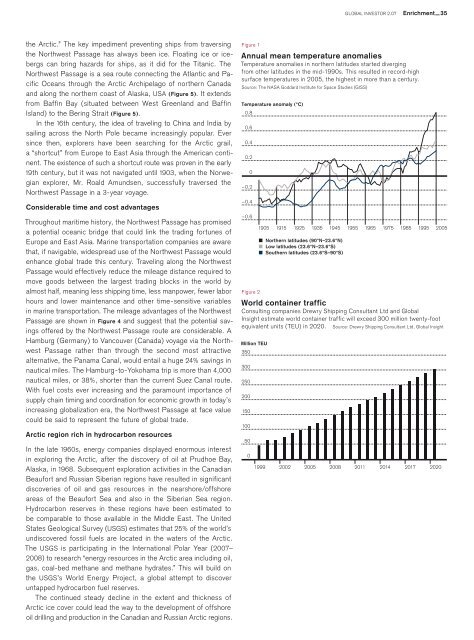
Figure 1<br />
Annual mean temperature anomalies<br />
Temperature anomalies in northern latitudes started diverging<br />
from other latitudes in the mid-1990s. This resulted in record-high<br />
surface temperatures in 2005, the highest in more than a century.<br />
Source: The NASA Goddard Institute for Space Studies (GISS)<br />
Temperature anomaly (°C)<br />
0.8<br />
0.6<br />
0.4<br />
0.2<br />
0<br />
–0.2<br />
–0.4<br />
–0.6<br />
Figure 2<br />
1905 1915 1925 1935 1945 1955 1965 1975 1985 1995<br />
Northern latitudes (90°N–23.6°N)<br />
Low latitudes (23.6°N–23.6°S)<br />
Southern latitudes (23.6°S–90°S)<br />
World container traffic<br />
Consulting companies Drewry Shipping Consultant Ltd and Global<br />
Insight estimate world container traffic will exceed 300 million twenty-foot<br />
equivalent units (TEU) in 2020. Source: Drewry Shipping Consultant Ltd, Global Insight<br />
Million TEU<br />
350<br />
300<br />
250<br />
200<br />
150<br />
100<br />
50<br />
0<br />
1999 2002 2005 2008 2011 2014 2017 2020<br />
2005