Historic Laredo
An illustrated history of the city of Laredo and the Webb County area, paired with the histories of companies, families and organizations that make the region great.
An illustrated history of the city of Laredo and the Webb County area, paired with the histories of companies, families and organizations that make the region great.

You also want an ePaper? Increase the reach of your titles
YUMPU automatically turns print PDFs into web optimized ePapers that Google loves.
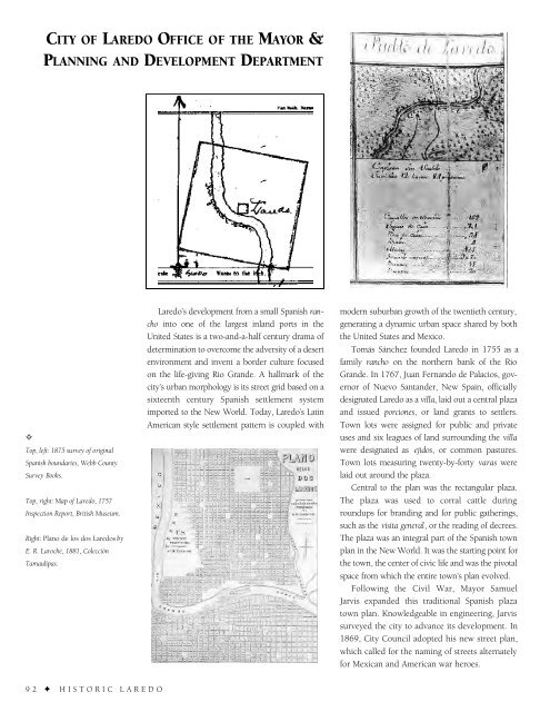
CITY OF LAREDO OFFICE OF THE MAYOR &<br />
PLANNING AND DEVELOPMENT DEPARTMENT<br />
✧<br />
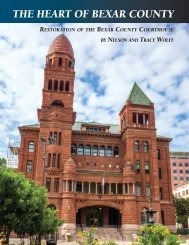
Top, left: 1875 survey of original<br />
Spanish boundaries, Webb County<br />
Survey Books.<br />
Top, right: Map of <strong>Laredo</strong>, 1757<br />
Inspection Report, British Museum.<br />
Right: Plano de los dos <strong>Laredo</strong>s by<br />
E. R. Laroche, 1881, Colección<br />
Tamaulipas.<br />
<strong>Laredo</strong>’s development from a small Spanish rancho<br />
into one of the largest inland ports in the<br />
United States is a two-and-a-half century drama of<br />
determination to overcome the adversity of a desert<br />
environment and invent a border culture focused<br />
on the life-giving Rio Grande. A hallmark of the<br />
city’s urban morphology is its street grid based on a<br />
sixteenth century Spanish settlement system<br />
imported to the New World. Today, <strong>Laredo</strong>’s Latin<br />
American style settlement pattern is coupled with<br />
modern suburban growth of the twentieth century,<br />
generating a dynamic urban space shared by both<br />
the United States and Mexico.<br />
Tomás Sánchez founded <strong>Laredo</strong> in 1755 as a<br />
family rancho on the northern bank of the Rio<br />
Grande. In 1767, Juan Fernando de Palacios, governor<br />
of Nuevo Santander, New Spain, officially<br />
designated <strong>Laredo</strong> as a villa, laid out a central plaza<br />
and issued porciones, or land grants to settlers.<br />
Town lots were assigned for public and private<br />
uses and six leagues of land surrounding the villa<br />
were designated as ejidos, or common pastures.<br />
Town lots measuring twenty-by-forty varas were<br />
laid out around the plaza.<br />
Central to the plan was the rectangular plaza.<br />
The plaza was used to corral cattle during<br />
roundups for branding and for public gatherings,<br />
such as the visita general, or the reading of decrees.<br />
The plaza was an integral part of the Spanish town<br />
plan in the New World. It was the starting point for<br />
the town, the center of civic life and was the pivotal<br />
space from which the entire town’s plan evolved.<br />
Following the Civil War, Mayor Samuel<br />
Jarvis expanded this traditional Spanish plaza<br />
town plan. Knowledgeable in engineering, Jarvis<br />
surveyed the city to advance its development. In<br />
1869, City Council adopted his new street plan,<br />
which called for the naming of streets alternately<br />
for Mexican and American war heroes.<br />
92 ✦ HISTORIC LAREDO