Historic Louisiana
An illustrated history of Louisiana, paired with the histories of companies, families and organizations that make the state great.
An illustrated history of Louisiana, paired with the histories of companies, families and organizations that make the state great.

Create successful ePaper yourself
Turn your PDF publications into a flip-book with our unique Google optimized e-Paper software.
✧<br />
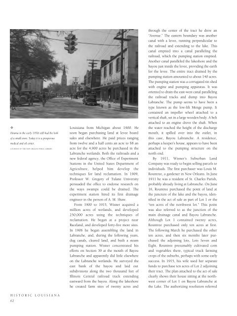
Houma in the early 1950s still had the look<br />
of a small town. Today it is a prosperous<br />
medical and oil center.<br />
COURTESY OF THE NEW ORLEANS PUBLIC LIBRARY.<br />
HISTORIC LOUISIANA<br />
62<br />
<strong>Louisiana</strong> from Michigan about 1900. He<br />
soon began purchasing land at levee board<br />
sales and elsewhere. He paid prices ranging<br />
from twelve and a half cents an acre to $8 an<br />
acre for the 4,900 acres he purchased in the<br />
Labranche wetlands. Both the railroads and a<br />
new federal agency, the Office of Experiment<br />
Stations in the United States Department of<br />
Agriculture, helped him develop the<br />
techniques for land reclamation. In 1909,<br />
Professor W. Gregory of Tulane University<br />
persuaded the office to endorse research on<br />
the ways swamps could be drained. The<br />
experiment station hired its first drainage<br />
engineer in the person of A. M. Shaw.<br />
From 1900 to 1915, Wisner acquired a<br />
million acres of wetlands, and developed<br />
250,000 acres using the techniques of<br />
reclamation. He began at a project near<br />
Raceland, and developed forty-five more sites.<br />
In 1906 he began assembling the land in<br />
Labranche, and, during the following years,<br />
dug canals, cleared land, and built a steam<br />
pumping station. Wisner concentrated his<br />
efforts on Section 39 at the mouth of Bayou<br />
Labranche and apparently did little elsewhere<br />
on the Labranche wetlands. He surveyed the<br />
east bank of the bayou and laid out<br />
subdivisions along the two thousand feet of<br />
Illinois Central railroad track extending<br />
eastward from the bayou. Along the lakeshore<br />
he created farm sites of twenty acres and<br />
through the center of the tract he drew an<br />
“Avenue.” The eastern boundary was another<br />
canal with a levee, running perpendicular to<br />
the railroad and extending to the lake. This<br />
canal emptied into a canal paralleling the<br />
railroad, which the pumping station emptied.<br />
Another canal paralleled the lakeshore and the<br />
bayou just inside the levee, providing the earth<br />
for the levee. The entire tract drained by the<br />
pumping station amounted to about 140 acres.<br />
The pumping station was a corrugated tin shed<br />
with engine and pumping apparatus. It was<br />
oriented to drain the east-west canal paralleling<br />
the railroad tracks and dump into Bayou<br />
Labranche. The pump seems to have been a<br />
type known as the low-lift Menge pump. It<br />
contained an impeller wheel attached to a<br />
vertical shaft, set in a large wooden body. A belt<br />
attached to an engine drove the shaft. When<br />
the water reached the height of the discharge<br />
mouth, it spilled over into the outlet, in<br />
this case, Bayou Labranche. A residence,<br />
perhaps a keeper’s house, appears to have been<br />
attached to the pumping structure on the<br />
north end.<br />
By 1911, Wisner’s Suburban Land<br />
Company was ready to begin selling parcels to<br />
individuals. The first purchaser was Louis M.<br />
Rountree, a gardener in New Orleans. In June<br />
1911 he was a resident of St. Charles Parish,<br />
probably already living at Labranche. On June<br />
16, Rountree purchased the point of land at<br />
the juncture of the lake and the bayou, identified<br />
in the act of sale as part of Lot 1 or the<br />
“ten acres of the northwest lot.” This point<br />
was also referred to as the junction of the<br />
main drainage canal and Bayou Labranche.<br />
Although Lot 1 contained twenty acres,<br />
Rountree purchased only ten acres at first.<br />
The following March he purchased the other<br />
ten acres, and then six months later purchased<br />
the adjoining lots, Lots Seven and<br />
Eight. Rountree presumably cultivated corn<br />
and vegetables there, typical truck farming<br />
crops of the suburbs, perhaps with some early<br />
success. In 1915, his wife used her separate<br />
funds to purchase ten acres of Lot 2 adjoining<br />
their tract. The plan attached to the act of sale<br />
clearly shows their house sitting at the northwest<br />
corner of Lot 1 on Bayou Labranche at<br />
the Lake. The authorizing resolution referred