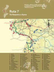
David Villa Entre Toix y la Serra Gelada Vinaròs - Comunidad ...
David Villa Entre Toix y la Serra Gelada Vinaròs - Comunidad ...
David Villa Entre Toix y la Serra Gelada Vinaròs - Comunidad ...

You also want an ePaper? Increase the reach of your titles
YUMPU automatically turns print PDFs into web optimized ePapers that Google loves.
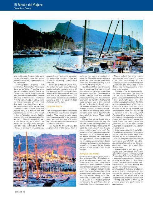
El Rincón del Viajero<br />
Traveller’s Corner<br />
some cavities in the limestone rocks, which<br />
are actually small springs that, during<br />
periods of heavy rains, impetuously spurt<br />
out freshwater.<br />
Although there is evidence of this<br />
aquifer since the time of the Phoenicians<br />
it was not until the 17 th century when<br />
the clergyman and historian Gaspar de<br />
Esco<strong>la</strong>no recorded it in writing in his<br />
book, Décadas de <strong>la</strong> historia de Valencia<br />
(Decades of the history of Valencia):<br />
“On the western side of Calpe, there<br />
is a cape or mountain, which they call<br />
Toyx, half a league from Hyfach, where,<br />
the same tongue of water has naturally<br />
carved out a cave, in which many wild<br />
pigeons nest, it is named after the<br />
pigeons and you cannot enter it except<br />
by boat ....” Esco<strong>la</strong>no exp<strong>la</strong>ins that the<br />
cave is one hundred steps wide and fiftytwo<br />
high “... Near the mouth of the cave,<br />
in the same tongue of water, an<br />
impetuous and huge river emerges<br />
from this rock. Although it doesn’t<br />
allow us to see how it enters the sea,<br />
CVNEWS 20<br />
because it is very suitable for anchoring,<br />
the boats sailing there feel its fury, and<br />
in fear of capsizing, they change<br />
direction....”<br />
Below <strong>Toix</strong> is the Barra Grande cove,<br />
the first on the route, a small beach of<br />
pebbles and rocks, measuring around 50<br />
metres which is difficult to reach from<br />
<strong>la</strong>nd but which does have a safe anchoring<br />
area due to its moderate swell. The<br />
Barra Grande, with spectacu<strong>la</strong>r underwater<br />
scenery, is one of the coves in Altea<br />
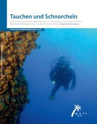
that is perfect for diving.<br />
FROM THE NORTH<br />
.......................................................<br />
After leaving behind the Barra Grande<br />
in the Morro de <strong>Toix</strong>, the route along the<br />
coast of Altea passes by rocky coves<br />
which have been eroded by the incessant<br />
waves and ends at a bay with gentle<br />
surf, a shore full of contrasts between<br />
nature and civilization.<br />
The Punta del Mascarat and the<br />
northern dam of the marina form a<br />
protected cove which is excellent for<br />
swimming. The pebble and gravel beach<br />
of Mascarat Norte, also has good diving<br />
conditions, due to the proximity to <strong>Toix</strong><br />
and the purity of its waters.<br />
After Mascarat Norte is the Greenwich<br />
Marina, a marina with a wide choice of<br />
accommodation, services, restaurants<br />
and leisure activities. The Greenwich<br />
Marina, through which the meridian<br />
passes at precisely zero, the same as in<br />
Greenwich, has more than five hundred<br />
boats and gives way to the Mascarat<br />
Sur or La Barreta de Gualda cove.<br />
The secluded <strong>la</strong> Barreta cove, 150 metres<br />
in length and which is easily accessible,<br />
has a mix of fine pebbles, small stones<br />
and some sand and is, together with<br />
Mascarat Norte, one of Altea’s nudist<br />
beaches.<br />
The next beach is the Solsida, which<br />
is nearly a kilometre and a half long. The<br />
Solsida is a beach with strong waves which<br />
is clear from its rugged appearance. To<br />
reach the beach you will have to walk<br />
along a difficult and rocky road. The<br />
passage smells of rosemary and <strong>la</strong>vender<br />
and the sound of the sea water keeps<br />
the walker company until they reach<br />
the rugged beach. The nature of Solsida<br />
has not made any compromises, it does<br />
not have any developments or buildings,<br />
no roads, no crops and the sea flows in<br />
and out of the ground it has bored<br />
through.<br />
BETWEEN TWO PORTS<br />
.......................................................<br />
Among the small Mar y Montaña ports,<br />
which are now Porto Senso, and the<br />
Portet de L’Ol<strong>la</strong>, the L‘Ol<strong>la</strong> beach<br />
stretches for over a kilometre with clear<br />
water and alternating sand, small pebbles<br />
and rock. The coastal road sometimes<br />
passes close by pine forests and sometimes<br />
travels through areas which have been<br />
artificially softened, among boats, sails,<br />
hammocks and beach bars. The beach<br />
of L‘Ol<strong>la</strong>, one of the most sought after<br />
and popu<strong>la</strong>r in the white town, allows for<br />
unlimited enjoyment of the sea and sun.<br />
L’Ol<strong>la</strong> was a c<strong>la</strong>ssic turn of the century<br />
summer resort and the proof is in some<br />
of its traditional buildings such as<br />
<strong>Vil<strong>la</strong></strong>garcía, which is divided into several<br />
apartments, and the pa<strong>la</strong>ce of <strong>Vil<strong>la</strong></strong><br />
Gadea, now the headquarters of the<br />
local police service.<br />
The <strong>la</strong>rger of the two is<strong>la</strong>nds in Altea,<br />
the Illeta, divides the L‘Ol<strong>la</strong> beach in<br />
two. The sun, sea and sky cling to this<br />
green, chalky, conch shell shaped is<strong>la</strong>nd<br />
which plummets down into the<br />
Mediterranean at its lowest part. The Illeta<br />
has a peculiar <strong>la</strong>ndscape, which is green<br />
during the winter months and multicoloured<br />
in the spring, however, the<br />
summer turns it brown while maintaining<br />
an explosion of life in the inner part of<br />
the is<strong>la</strong>nd. Deep underwater, the Illeta<br />
dominates the great posidonia meadow<br />
through which the barbell, pol<strong>la</strong>ck and<br />
b<strong>la</strong>ck moray fish swim quietly, the<br />
protection zone of the <strong>Serra</strong> Ge<strong>la</strong>da<br />
natural park having given them a breather<br />
in recent years.<br />
In the <strong>la</strong>st part of the trip through L’Ol<strong>la</strong>,<br />
the pebble and gravel beach disappears<br />
and becomes an area with <strong>la</strong>rge rocks<br />
sculpted by the Mediterranean swell.<br />
The route along the cobbled pavement<br />
comes to an end at Portet de L’Ol<strong>la</strong>,<br />
one of the smallest ports on the Valencian<br />
coast with capacity for around thirty<br />
small vessels.<br />
El Portet leads to Soio, a rocky cove,<br />
slightly over 100 metres, with b<strong>la</strong>ck<br />
rocks which reveal the volcanic origin of<br />
the cape that shelters it and with sporadic<br />
invasions of seaweed means it tends to<br />
be quite empty, even in the summer<br />
months. The small bay of the Soio cove,<br />
very near to the posidonia meadow, has<br />
spectacu<strong>la</strong>r underwater scenery.<br />
A rocky cape with thick pine forest which<br />
is home to the chalet known as the<br />
home of the minister is the prelude to<br />
the beach of Cap Negret, one of the<br />
longest in Altea at nearly a kilometre and<br />
half long. Cap Negret is made up of<br />
pebbles, gravel and golden sand in<br />
several areas.