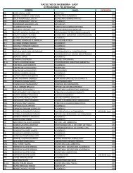
Plan de Estudios - Facultad de IngenierÃa - Universidad Autónoma ...
Plan de Estudios - Facultad de IngenierÃa - Universidad Autónoma ...
Plan de Estudios - Facultad de IngenierÃa - Universidad Autónoma ...

You also want an ePaper? Increase the reach of your titles
YUMPU automatically turns print PDFs into web optimized ePapers that Google loves.
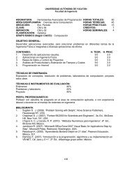
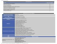
Maestría en Ingeniería<br />
<strong>Facultad</strong> <strong>de</strong> Ingeniería - UADY<br />
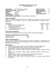
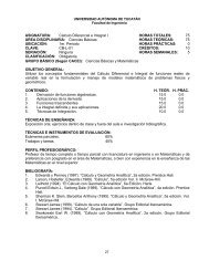
ASIGNATURA: Sistemas <strong>de</strong> Información<br />
HORAS TOTALES: 60<br />
Geográfica<br />
ÁREA DISCIPLINARIA: Ingeniería <strong>de</strong> la Construcción HORAS TEÓRICAS: 45<br />
UBICACIÓN: Cualquier periodo HORAS PRÁCTICAS: 15<br />
CLAVE: IC-M-57 CRÉDITOS: 7<br />
SERIACIÓN: Ninguna HORAS SEMANALES: 4<br />
CLASIFICACIÓN: Optativa<br />
OBJETIVO GENERAL:<br />
Aplicar sistemas <strong>de</strong> información geográfica para mo<strong>de</strong>lar soluciones a problemas <strong>de</strong><br />
ingeniería.<br />
CONTENIDO:<br />
1. Introducción<br />
2. Concepto y generación <strong>de</strong> proyectos<br />
3. Sistemas <strong>de</strong> Coor<strong>de</strong>nadas<br />
4. Elementos gráficos<br />
5. Almacenamiento <strong>de</strong> información alfanumérica<br />
6. Generación <strong>de</strong> topología<br />
7. Análisis espacial y alfanumérico<br />
8. Análisis <strong>de</strong> rastreo <strong>de</strong> red<br />
9. Aplicaciones<br />
TÉCNICAS DE ENSEÑANZA:<br />
Se empleará Exposición <strong>de</strong> conceptos por el profesor y discusión en el salón <strong>de</strong> clase.<br />
Resolución <strong>de</strong> problemas, lectura y discusión <strong>de</strong> artículos técnicos o científicos.<br />
TÉCNICAS E INSTRUMENTOS DE EVALUACIÓN:<br />
Exámenes 30%<br />
Tareas 30%<br />
Proyecto integrador 40%<br />
PERFIL PROFESIOGRÁFICO:<br />
Posgrado en Ingeniería con experiencia en el área.<br />
BIBLIOGRAFÍA:<br />
1. Gurnell, A.M.; Montgomery, D. R. (2000). Hydrological Applications of Gis. John Wiley<br />
and Sons.<br />
2. Pin<strong>de</strong>r, George F. (2002). Groundwater mo<strong>de</strong>ling, using Geographical Information<br />
Systems. John Wiley and Sons.<br />
3. Heywood, Ian; Cornelius, Sara; Carver, Steve; Grohar-Murray, Mary E. (2002). An<br />
Introduction to Geographical Information Systems, Second Edition, Prentice Hall College<br />
Division.<br />
4. Ormaby, Tim; Alvy, Jonell (1999). Extending ArcView GIS: with Network Analyst, Spatial<br />
Analyst and 3D Analyst. ESRI Press.<br />
5. Ma<strong>de</strong>j, Ed (2000). Cartographic Design Using Arcview GIS, OnWord, Press<br />
6. Charisman, Nicholas (2001). Exploring Geographical Information Systems, 2nd Edition,<br />
John Wiley & Sons; 2nd edition<br />
__________________________________________________________________________<br />
Aprobado por el Consejo Universitario el 31 <strong>de</strong> agosto <strong>de</strong> 2010 128