- Page 1 and 2:
Foto: Parque Entre Nubes, Localidad
- Page 3:
GeógrafoWilliam Andrés Castillo S
- Page 6 and 7:
Por otro lado la participación com
- Page 8 and 9:
1.8.1 Mortalidad ..................
- Page 10 and 11:
TABLA 1. DISTRIBUCIÓN POBLACIÓN S
- Page 12 and 13:
INDICE DE GRAFICASGRAFICA 1.PIRÁMI
- Page 14 and 15:
INDICE DE MAPASMAPA 1.BARRIOS LOCAL
- Page 16 and 17:
El proceso metodológico trabajado
- Page 18 and 19: entre poderes, es decir, se hace en
- Page 20 and 21: Gestión Social Integral, donde se
- Page 22: 18 IAFI Institución Amiga de la Fa
- Page 25 and 26: crecimiento desordenado de la pobla
- Page 27 and 28: iesgo por remoción de masa y riesg
- Page 29 and 30: encuentran en diferentes grados de
- Page 31 and 32: izquierdo del Fucha recorre la loca
- Page 33 and 34: 1.2.7 Factores de deterioro ambient
- Page 35 and 36: corredores han desaparecido. Por ot
- Page 37 and 38: Las UPZ que presentan mayor contami
- Page 39 and 40: En cuanto a la relación con el med
- Page 41 and 42: 1.3. DINÁMICA TERRITORIALExisten d
- Page 43 and 44: Mapa 5. UPZ L o ca lida d C u arta
- Page 45 and 46: En la localidad San Cristóbal pred
- Page 47 and 48: Las relaciones ínter barriales se
- Page 49 and 50: amplia comunidad que participo en e
- Page 51 and 52: 1.3.3 Territorios de Gestión Socia
- Page 53 and 54: del Gavilán, se evidencia uso inad
- Page 55 and 56: La gráfica nos permite ver que aco
- Page 57 and 58: Tabla 1 . Dis tr ib uc ión poblaci
- Page 59 and 60: conformados por Madres jefes de fam
- Page 61 and 62: A continuación se realiza un anál
- Page 63: Tabla 5 . P orcent aje de Nacidos V
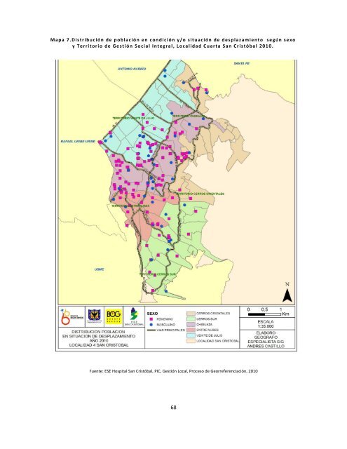
- Page 66 and 67: diferentes territorios donde hay as
- Page 70 and 71: epresentatividad adulto mayor, las
- Page 72 and 73: cultura o baja oferta a los mismos,
- Page 74 and 75: AÑOS1.8. PERFIL EPIDEMIOLÓGICO1.8
- Page 76 and 77: población, ya que muchas de las en
- Page 78 and 79: Distrito después de Ciudad Bolíva
- Page 80 and 81: Hasta el 2005 la neumonía se encon
- Page 82 and 83: Tabla 13. Pr imeras Causas de M ort
- Page 84 and 85: 1.10. MORTALIDAD MATERNAGrafica 8.
- Page 86 and 87: Fuente: ESE Hospital San Cristóbal
- Page 88 and 89: Grafica 11.T asa de m or ta lid ad
- Page 90 and 91: Mapa 9.M orta lidad Mater na y M or
- Page 92 and 93: Fuente: Base de datos Secretaria Di
- Page 94 and 95: 1.12.1 MorbilidadLa ESE. San Crist
- Page 96 and 97: Mapa 11. No tif ica c ió n Sivigil
- Page 98 and 99: Tabla 20. D istr ibu c ió n de la
- Page 100 and 101: Fuente: ESE Hospital San Cristóbal
- Page 102 and 103: De acuerdo con el sexo, etapa del c
- Page 104 and 105: Al observar la georreferenciación
- Page 106 and 107: Contracción 311 2 0 0 313Acciones
- Page 108 and 109: elaboración de productos alimentic
- Page 110 and 111: Tabla 24. Pobla c ió n O cu p ada
- Page 112 and 113: El Índice de Condiciones de Vida d
- Page 114 and 115: Mapa 14. Dis tr ib uc ión trabaj o
- Page 116 and 117: Vinculado a la deficiencia de ingre
- Page 118 and 119:
El servicio de recolección de resi
- Page 120 and 121:
Grafica 16.Núm ero de H o gares po
- Page 122 and 123:
Es de resaltar el bajo nivel educat
- Page 124 and 125:
2.4. TRANSPORTEEl sistema vial est
- Page 126 and 127:
nutrición, riesgos profesionales,
- Page 128 and 129:
Para los jóvenes de la localidad h
- Page 130 and 131:
este territorio no se cuentan con l
- Page 132 and 133:
Tabla 29. P arques y Z on as Ver de
- Page 134 and 135:
Mapa 15. Pa rq u es y Zonas Ver d e
- Page 136 and 137:
tiendas en algunas zonas de la loca
- Page 138 and 139:
San Blas, es decir están concentra
- Page 140 and 141:
2.6.4 Componente: Aprovechamiento B
- Page 142 and 143:
Tabla 33. Indicador pes o para la t
- Page 144 and 145:
Tabla 35. Indicador ín d ic e de m
- Page 146 and 147:
3. ANÁLISIS DE CONDICIONES DECALID
- Page 148 and 149:
Inicialmente los territorios Cerros
- Page 150 and 151:
San Pedro, San Jerónimo de Yuste,
- Page 152 and 153:
Por otra parte es de resaltar que e
- Page 154 and 155:
EXPOSICIÓN RÁBICA 16VARICELA INDI
- Page 156 and 157:
sus familias constantemente están
- Page 158 and 159:
existe oferta institucional para es
- Page 160 and 161:
actividades delictivas que realizan
- Page 162 and 163:
De la misma forma la población adu
- Page 164 and 165:
Existen grupos poblacionales partic
- Page 166 and 167:
En cuanto a la red pluvial - aguas
- Page 168 and 169:
distribuidos de la siguiente forma:
- Page 170 and 171:
Por otra parte es importante mencio
- Page 172 and 173:
Por otra parte las problemáticas d
- Page 174 and 175:
eubicación de familias hacia otras
- Page 176 and 177:
3.2. TERRITORIO CERROS SURORIENTALE
- Page 178 and 179:
3.2.2 Dinámica Poblacional Territo
- Page 180 and 181:
sociales, económicos, culturales y
- Page 182 and 183:
los espacios de trabajo no sean ade
- Page 184 and 185:
Tabla 40. Res ulta do s C it ologí
- Page 186 and 187:
largo tiempo hablando, además de p
- Page 188 and 189:
3.3. TERRITORIO 20 DE JULIOEl terri
- Page 190 and 191:
3.3.2 Dinámica Poblacional Territo
- Page 192 and 193:
desarrollo y en consecuencia, con n
- Page 194 and 195:
cuentan con negocio propio como: pa
- Page 196 and 197:
Acorde a la notificación se eviden
- Page 198 and 199:
3.4. TERRITORIO ENTRE NUBESEl terri
- Page 200 and 201:
3.4.2 Dinámica Poblacional Territo
- Page 202 and 203:
emunerados lo que obliga a muchos n
- Page 204 and 205:
el grupo de persona mayor con disca
- Page 206 and 207:
Núcleos Problemáticos Territorio
- Page 208 and 209:
delincuencia ejercida por adultos h
- Page 210 and 211:
3.5.1 Características Geográficas
- Page 212 and 213:
Etapa InfanciaEn la etapa infancia,
- Page 214 and 215:
los niños y niñas presentes en es
- Page 216 and 217:
Existen muy pocos programas que pro
- Page 218 and 219:
Se ha evidenciado que otro de los f
- Page 220 and 221:
formas debido entre otras a pautas
- Page 222 and 223:
4. ANALISIS DE LA RESPUESTASOCIAL Y
- Page 224 and 225:
Tabla 43. Ofer ta de sa lu d , seg
- Page 226 and 227:
significativo de la consulta en ins
- Page 228 and 229:
Frente a la Etapa del ciclo vital a
- Page 230 and 231:
Grafica 24. Intervenció n del Ámb
- Page 232 and 233:
Mapa 24 . C it olog ías con r esul
- Page 234 and 235:
distrital de infancia en su compone
- Page 236 and 237:
Según la división por territorios
- Page 238 and 239:
esaltando la necesidad de implantar
- Page 240 and 241:
Micro territorios Salud a Su CasaA
- Page 242 and 243:
Componente 3. Vigilancia en Salud P
- Page 244 and 245:
Fuente: ESE Hospital San Cristóbal
- Page 246 and 247:
Mapa 29 . L íne a de me d ic a men
- Page 248 and 249:
verdes sobre el barrio Canadá Guir
- Page 250 and 251:
ambientales, involucrando la partic
- Page 252 and 253:
pendiente por vacunar y realizar in
- Page 254 and 255:
que permite abordar las problemáti
- Page 256 and 257:
depósitos de material de construcc
- Page 258 and 259:
cuando está en gestación se invis
- Page 260 and 261:
Desde el ámbito comunitario se fom
- Page 262 and 263:
Se está promoviendo la Movilizaci
- Page 264 and 265:
Psicología, Terapia Ocupacional, T
- Page 266 and 267:
uente: ESE Hospital San Cristóbal,
- Page 268 and 269:
Tabla 47. C asas vecina les sub d i
- Page 270 and 271:
13.611 21.340 2.540 10 0 0 35.038 7
- Page 272 and 273:
Mapa 17. C oleg ios L o ca lid ad C
- Page 274 and 275:
Secretaria Local De Integración So
- Page 276 and 277:
Mapa 18. Oferta para s op orte Seg
- Page 278 and 279:
grupos, se ha obtenido por medio de
- Page 280 and 281:
Externa. Dirigida a personas con li
- Page 282 and 283:
La población objetivo incluye a la
- Page 284 and 285:
Grafica 25. Aseg uram ie nt o P ob
- Page 286 and 287:
En nivel 1 hay 92.033 personas, 194
- Page 288 and 289:
El monto de inversión que se conce
- Page 290 and 291:
aportando de manera directa a la di
- Page 292 and 293:
por la deficiencia de luz, agua, al
- Page 294 and 295:
nos propusimos redactar lo que llam
- Page 296 and 297:
Los antecedentes históricos de la
- Page 298 and 299:
Actualmente se ha ejercido veedurí
- Page 300 and 301:
En el aspecto educativo se debe se
- Page 302 and 303:
comunidad., no había claridad en c
- Page 304 and 305:
almacenamiento de estas sustancias
- Page 306 and 307:
Estas personas encuestadas pertenec
- Page 308 and 309:
403530252015105Fuente:0SIN DIFICULT
- Page 310 and 311:
como la percepción de falta de int
- Page 312 and 313:
Desde ámbito familiar realización
- Page 314 and 315:
El tema generador es: “Territorio
- Page 316 and 317:
exigibilidad de derechos de los y l
- Page 318 and 319:
propone procesos de organización p
- Page 320 and 321:
formación de gestores comunitarios
- Page 322 and 323:
El séptimo núcleo problematizador
- Page 324:
El cuarto núcleo problematizador e