Revue internationale d'écologie méditerranéenne International ...
Revue internationale d'écologie méditerranéenne International ...
Revue internationale d'écologie méditerranéenne International ...

You also want an ePaper? Increase the reach of your titles
YUMPU automatically turns print PDFs into web optimized ePapers that Google loves.
Results<br />
A syntaxonomical and synecological research on the steppe vegetation of the Karacadağ Mountain (Şanlıurfa-Diyarbakır / Turkey)<br />
Brief description of the area<br />
Geography<br />
Karacadağ is an extinct volcanic body lying<br />
between northwest of Şanlıurfa and southwest<br />
of Diyarbakır with the direction of northsouth.<br />
Geographic position of Karacadağ is in<br />
between 37 o 30’ 25’’-37 o 59’ 05’’ north latitudes<br />
and 39 o 20’ 27’’-40 o 0’ 0’’ east longitudes. e<br />
top point of Karacadağ Mountain is Mirgimir<br />
Hill (1981 m). e other important altitudes<br />
of Karacadağ are Mandal Hill (1895 m),<br />
Besrek Hill (1350 m), Keluşak Hill, Hazel Hill<br />
(1839 m), Bakşo Hill (1883 m) and Kollubaba<br />
Hill (1957 m). Most of these hills are chapped<br />
by small streams which dry in summers.<br />
Geology<br />
Volcanic Karacadağ body separates Southeastern<br />
Anatolia into two drainage basins; one<br />
of them is Tigris river in the east and the other<br />
is Euphrates river in the west. is body can<br />
be described as a big lava shield composed of<br />
basaltic lavas. Karacadağ volcanic body is<br />
formed through overlapping of basaltic lava<br />
domes. ere is no volcanic structure on<br />
Karacadağ that is eroded excessively. e<br />
slope of volcanic (~2 o ) body from top to the<br />
periphery parts is very low (Sözer 1984). As<br />
Karacadağ is not very high it also does not<br />
seem grandiosely. e lava plateau which also<br />
includes Karacadağ has such low slope that it<br />
seems flat. A little increase in this slope is seen<br />
in the piedmonts of Karacadağ. e Karacadağ<br />
body is chapped by the valleys which lie<br />
from the center to the periphery in a beam<br />
like manner (Tolun 1954). e Karacadağ<br />
block has taken today’s shape as a result of the<br />
tectonic events occurred at the end of<br />
Pleocene era and at the beginning of Pleistocene<br />
era (Sayar 1932).<br />
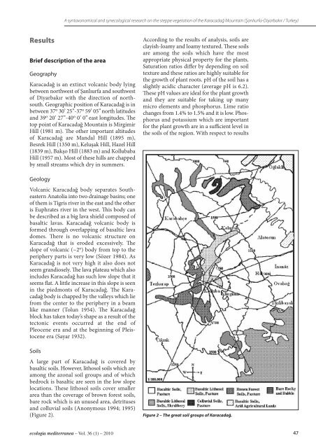
Soils<br />
A large part of Karacadağ is covered by<br />
basaltic soils. However, lithosol soils which are<br />
among the azonal soil groups and of which<br />
bedrock is basaltic are seen in the low slope<br />
locations. ese lithosol soils cover smaller<br />
area than the coverage of brown forest soils,<br />
bare rock which is an unused area, detrituses<br />
and colluvial soils (Anonymous 1994; 1995)<br />
(Figure 2).<br />
ecologia mediterranea – Vol. 36 (1) – 2010<br />
According to the results of analysis, soils are<br />
clayish-loamy and loamy textured. ese soils<br />
are among the soils which have the most<br />
appropriate physical property for the plants.<br />
Saturation ratios differ by depending on soil<br />
texture and these ratios are highly suitable for<br />
the growth of plant roots. pH of the soil has a<br />
slightly acidic character (average pH is 6.2).<br />
ese pH values are ideal for the plant growth<br />
and they are suitable for taking up many<br />
micro elements and phosphorus. Lime ratio<br />
changes from 1.4% to 1.5% and it is low. Phosphorus<br />
and potassium which are important<br />
for the plant growth are in a sufficient level in<br />
the soils of the region. With respect to results<br />
Figure 2 – The great soil groups of Karacadağ.<br />
47