

GEOmedia_5_2020
La prima rivista italiana di Geomatica
La prima rivista italiana di Geomatica

You also want an ePaper? Increase the reach of your titles
YUMPU automatically turns print PDFs into web optimized ePapers that Google loves.
FOCUS<br />
thinks about maps.”<br />
Per ora, il successo dell'azienda<br />
dipende dalla piattaforma di<br />
mapping che Mapillary ha costruito.<br />
“As more images are contributed<br />
by users, the more training<br />
data we can use to improve<br />
our AI algorithms, eventually<br />
resulting to the best mapping<br />
data available for everyone,”<br />
aggiunge Solem. “As we say at<br />
Mapillary, collaboration wins.”<br />
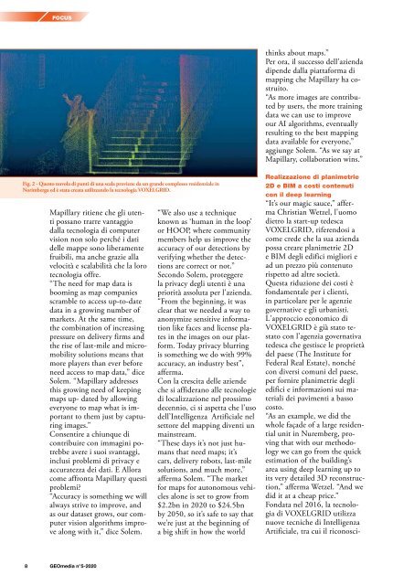
Fig. 2 - Questo nuvola di punti di una scala proviene da un grande complesso residenziale in<br />
Norimberga ed è stata creata utilizzando la tecnologia VOXELGRID.<br />
Mapillary ritiene che gli utenti<br />
possano trarre vantaggio<br />
dalla tecnologia di computer<br />
vision non solo perché i dati<br />
delle mappe sono liberamente<br />
fruibili, ma anche grazie alla<br />
velocità e scalabilità che la loro<br />
tecnologia offre.<br />
“The need for map data is<br />
booming as map companies<br />
scramble to access up-to-date<br />
data in a growing number of<br />
markets. At the same time,<br />
the combination of increasing<br />
pressure on delivery firms and<br />
the rise of last-mile and micromobility<br />
solutions means that<br />
more players than ever before<br />
need access to map data,” dice<br />
Solem. “Mapillary addresses<br />
this growing need of keeping<br />
maps up- dated by allowing<br />
everyone to map what is important<br />
to them just by capturing<br />
images.”<br />
Consentire a chiunque di<br />
contribuire con immagini potrebbe<br />
avere i suoi svantaggi,<br />
inclusi problemi di privacy e<br />
accuratezza dei dati. E Allora<br />
come affronta Mapillary questi<br />
problemi?<br />
“Accuracy is something we will<br />
always strive to improve, and<br />
as our dataset grows, our computer<br />
vision algorithms improve<br />
along with it,” dice Solem.<br />
“We also use a technique<br />
known as ‘human in the loop’<br />
or HOOP, where community<br />
members help us improve the<br />
accuracy of our detections by<br />
verifying whether the detections<br />
are correct or not.”<br />
Secondo Solem, proteggere<br />
la privacy degli utenti è una<br />
priorità assoluta per l'azienda.<br />
“From the beginning, it was<br />
clear that we needed a way to<br />
anonymize sensitive information<br />
like faces and license plates<br />
in the images on our platform.<br />
Today privacy blurring<br />
is something we do with 99%<br />
accuracy, an industry best”,<br />
afferma.<br />
Con la crescita delle aziende<br />
che si affiderano alle tecnologie<br />
di localizzazione nel prossimo<br />
decennio, ci si aspetta che l'uso<br />
dell’Intelligenza Artificiale nel<br />
settore del mapping diventi un<br />
mainstream.<br />
“These days it’s not just humans<br />
that need maps; it’s<br />
cars, delivery robots, last-mile<br />
solutions, and much more,”<br />
afferma Solem. “The market<br />
for maps for autonomous vehicles<br />
alone is set to grow from<br />
$2.2bn in <strong>2020</strong> to $24.5bn<br />
by 2050, so it’s safe to say that<br />
we’re just at the beginning of<br />
a big shift in how the world<br />
Realizzazione di planimetrie<br />
2D e BIM a costi contenuti<br />
con il deep learning<br />
“It’s our magic sauce,” afferma<br />
Christian Wetzel, l'uomo<br />
dietro la start-up tedesca<br />
VOXELGRID, riferendosi a<br />
come crede che la sua azienda<br />
possa creare planimetrie 2D<br />
e BIM degli edifici migliori e<br />
ad un prezzo più contenuto<br />
rispetto ad altre società.<br />
Questa riduzione dei costi è<br />
fondamentale per i clienti,<br />
in particolare per le agenzie<br />
governative e gli urbanisti.<br />
L'approccio economico di<br />
VOXELGRID è già stato testato<br />
con l'agenzia governativa<br />
tedesca che gestisce le proprietà<br />
del paese (The Institute for<br />
Federal Real Estate), nonché<br />
con diversi comuni del paese,<br />
per fornire planimetrie degli<br />
edifici e informazioni sui materiali<br />
dei pavimenti a basso<br />
costo.<br />
“As an example, we did the<br />
whole façade of a large residential<br />
unit in Nuremberg, proving<br />
that with our methodology<br />
we can go from the quick<br />
estimation of the building’s<br />
area using deep learning up to<br />
its very detailed 3D reconstruction,”<br />
afferma Wetzel. “And we<br />
did it at a cheap price.”<br />
Fondata nel 2016, la tecnologia<br />
di VOXELGRID utilizza<br />
nuove tecniche di Intelligenza<br />
Artificiale, tra cui il riconosci-<br />
8 <strong>GEOmedia</strong> n°5-<strong>2020</strong>


