GEOmedia 4 2022
Rivista italiana di geomatica
Rivista italiana di geomatica
Create successful ePaper yourself
Turn your PDF publications into a flip-book with our unique Google optimized e-Paper software.
GUEST<br />
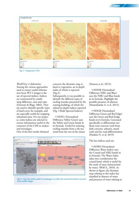
Fig. 5 - Temperature TOA.<br />
WorldView 2 elaboration<br />
Among the various approaches<br />
used to extract useful information<br />
from WV-2 images is the<br />
use of spectral indices. Indices<br />
are constructed by combining<br />
difference, sum and ratio<br />
(Dermais & Biagi, 2002). They<br />
are used to identify specific types<br />
of land cover, for example, and<br />
are especially useful for mapping<br />
urbanized areas. For our purpose,<br />
some indices are selected to<br />
extract information useful to the<br />
construct of the CIM to analyse<br />
and investigate.<br />
One of the first results obtained<br />
concerns the thematic map related<br />
to vegetation, an in-depth<br />
index of which is reported<br />
(Fig.2):<br />
Subsequently, it was possible to<br />
identify the different types of<br />
roofing mantles presented by the<br />
existing building, of which the<br />
related in-depth indices reported<br />
(Fig. 3 Built Spectral Indices):<br />
• NDYG (Normalized<br />
Difference Yellow Green) uses<br />
the Yellow and Green bands in<br />
its formula. Useful for isolating<br />
roofing mantles from a tile material<br />
from the rest of the classes<br />
(Stamou et al., 2012);<br />
• NDNB (Normalized<br />
Difference NIR1 and Blue)<br />
uses the NIR1 and Blue bands<br />
in its formula. Highlight the<br />
possible presence of asbestos<br />
(Hamedianfar A. et al. 2015);<br />
• NDGR (Normalized<br />
Difference Green and Red Edge)<br />
uses the Green and Red-Eedge<br />
bands in its formula. Generated<br />
specifically to differentiate medium<br />
tone concrete roofs from<br />
dark concrete, asbestos, metal<br />
roofs and for road differentiation<br />
(Hashim N. et al. 2019).<br />
The last indices used are:<br />
Fig. 6 - Overview of the model in Grasshopper, in yellow the associated attribute extracted<br />
from satellite images.<br />
• NDWI (Normalized<br />
Difference Water Index) uses<br />
the Coastal and NIR2 bands in<br />
its formula. The Water Index<br />
takes into consideration the<br />
coastal band, which is useful for<br />
the study of areas characterized<br />
by water. (Wolf A., 2010). As<br />
shown in figure, the thematic<br />
map relating to this index has<br />
classified in absence of water<br />
and presence of water relating to<br />
<strong>GEOmedia</strong> n°4-<strong>2022</strong> 31


