

GEOmedia 4 2022
Rivista italiana di geomatica
Rivista italiana di geomatica

You also want an ePaper? Increase the reach of your titles
YUMPU automatically turns print PDFs into web optimized ePapers that Google loves.
GUEST<br />
Construction and<br />
application of CIM<br />
All the extracted information by<br />
the Multispectral images is added<br />
to Geographic open data, in<br />
order to obtain an updated basemap<br />
to construct the CIM. In<br />
addition, the Digital Elevation<br />
Model (made by interpolating<br />
the elevation data taken from the<br />
DBTR; the cell size is 10 meters<br />
per side and the reference system<br />
is UTM-WGS84) was used to<br />
create the surface reference system<br />
and to obtain the 3D model<br />
of the study area. Other data<br />
from official sources regarding<br />
the hydraulic, hydrogeological,<br />
pyrological risk and seismic microzonation<br />
of the territory and<br />
the analysis of the constraints<br />
and values present in the area<br />
under study, were analysed.<br />
Next, all institutional information<br />
consulted and obtained<br />
was "linked" to the appropriate<br />
levels.<br />
In detail, for our study area, the<br />
DBTR of the Abruzzo region<br />
was used and updated (available<br />
free of charge from the http://<br />
opendata.regione.abruzzo.it/<br />
website). However, since this last<br />
file was dated before the 2009<br />
earthquake that struck the city<br />
of L'Aquila, and therefore lacking<br />
all the new buildings and<br />
the most recent transformations<br />
that took place in the territory,<br />
it was integrated with the use of<br />
the following files:<br />
- For the building, a shapefile<br />
downloaded from the site http://<br />
wms.pcn.minambiente.it, as<br />
it is more up-to-date than the<br />
DBTR;<br />
- Finally, a new shapefile created<br />
specifically for missing buildings<br />
with the help of Osm (open street<br />
map).<br />
Thus, all the data processed and<br />
described previously, will be implemented<br />
in GIS (Geographic<br />
Information System) software<br />
for creating a real 3D model of<br />
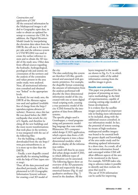
Fig. 7 - Overview of the model in Grasshopper, in yellow the associated attribute<br />
extracted from satellite images.<br />
the city.<br />
The data underlying this system<br />
are therefore GIS-like, georeferenced<br />
and associated with geometric<br />
primitives. For example,<br />
the shapefile format containing<br />
the amount of information from<br />
the analyses performed will<br />
describe the three-dimensional<br />
information model of the city,<br />
created with one or more digital<br />
visual scripting tools, creating<br />
a true parametric model of the<br />
city (CIM) formed by the integration<br />
of data from different<br />
systems.<br />
The specific plugin used is<br />
Grasshopper, a visual programming<br />
and parametric modelling<br />
language that runs within<br />
Rhinoceros 3D's computeraided<br />
design (CAD) application,<br />
which exports data from a GIS<br />
tool and imports it into a threedimensional<br />
modeler, which<br />
allows to display all the information<br />
within.<br />
The result will thus be an extended<br />
urban design model (CIM),<br />
to which different types of<br />
information can be associated.<br />
The following figures show an<br />
overview of the 3D parametric<br />
model and respectively the geometrical<br />
features (Fig. 6) and<br />
qualitative attributes (Fig. 7)<br />
stored in the database. All the<br />
layers integrated in the model<br />
are shown in Fig. 8 e 9, in which<br />
a summary table of the added<br />
information coming from the<br />
satellite images is given.<br />
Results and conclusion<br />
This paper was produced for the<br />
purpose of presenting an innovative<br />
methodology in the field<br />
of experimentation, capable of<br />
creating cutting-edge models of<br />
future development.<br />
It is evident that the satellite<br />
images used played an important<br />
role in finding more information<br />
to be included, along with the<br />
additional sources consulted, in<br />
our information model. In fact,<br />
the potential of remote sensing<br />
by means of high-resolution<br />
multispectral satellite imagery<br />
was found to be essential both<br />
for greater depth and knowledge<br />
of the area under study and for<br />
obtaining updated information<br />
in a short time. As a result, all of<br />
the various information found<br />
and converged within CIM will<br />
allow different aspects of the area<br />
to be monitored in the future.<br />
For example, NDNB index relating<br />
to asbestos makes it possible<br />
to identify and then reclaim the<br />
areas that need it.<br />
The use of TOA information<br />
can be useful for improving<br />
<strong>GEOmedia</strong> n°4-<strong>2022</strong> 33


