400/500 Series Garmin Optional Displays
400/500 Series Garmin Optional Displays
400/500 Series Garmin Optional Displays

Create successful ePaper yourself
Turn your PDF publications into a flip-book with our unique Google optimized e-Paper software.
12<br />
Section 2<br />
NEXRAD Overview<br />
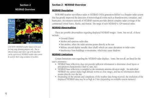
CAUTION: NEXRAD weather data is to be used<br />
for long-range planning purposes only. Due to<br />
inherent delays and relative age of the data that<br />
can be experienced, NEXRAD weather data cannot<br />
be used for short-range avoidance of weather.<br />
Section 2: NEXRAD Overview<br />
NEXRAD Description<br />
WSR-88D weather surveillance radar or NEXRAD (NEXt generation RADar) is a Doppler radar system<br />
that has greatly improved the detection of meteorological events such as thunderstorms, tornadoes, and<br />
hurricanes. An extensive network of NEXRAD stations provides almost complete radar coverage of the<br />
continental United States, Alaska, and Hawaii. The range of each NEXRAD is 124 nautical miles.<br />
NEXRAD Abnormalities<br />
There are possible abnormalities regarding displayed NEXRAD images. Some, but not all, of those<br />
include:<br />
• Ground Clutter<br />
• Strobes and spurious radar data<br />
• Sun strobes, when the radar antenna points directly at the sun<br />
• Military aircraft deploy metallic dust (chaff) which can cause alterations in radar scans<br />
• Interference from buildings or mountains, which may cause shadows<br />
NEXRAD Limitations<br />
Certain limitations exist regarding the NEXRAD radar displays. Some, but not all, are listed for the<br />
user’s awareness:<br />
• NEXRAD base reflectivity does not provide sufficient information to determine cloud layers or<br />
precipitation characteristics (hail vs. rain, etc).<br />
• NEXRAD base reflectivity is sampled at the minimum antenna elevation angle. An individual<br />
NEXRAD site cannot depict high altitude storms at close ranges, and has no information about<br />
storms directly over the site.<br />
• Depending on the amount and complexity of the weather data being received, the resolution of the<br />
displayed NEXRAD data may be as high as 2 km (depending on available system memory).