400/500 Series Garmin Optional Displays
400/500 Series Garmin Optional Displays
400/500 Series Garmin Optional Displays

Create successful ePaper yourself
Turn your PDF publications into a flip-book with our unique Google optimized e-Paper software.
20<br />
Section 4<br />
METAR Operation<br />
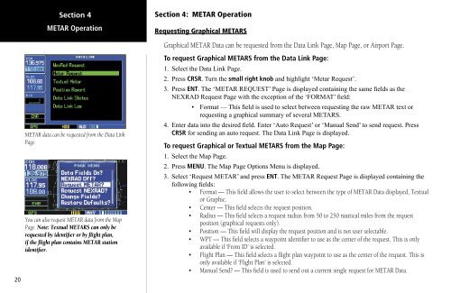
METAR data can be requested from the Data Link<br />
Page.<br />
You can also request METAR data from the Map<br />
Page. Note: Textual METARS can only be<br />
requested by identifier or by flight plan,<br />
if the flight plan contains METAR station<br />
identifier.<br />
Section 4: METAR Operation<br />
Requesting Graphical METARS<br />
Graphical METAR Data can be requested from the Data Link Page, Map Page, or Airport Page.<br />
To request Graphical METARS from the Data Link Page:<br />
1. Select the Data Link Page.<br />
2. Press CRSR. Turn the small right knob and highlight ‘Metar Request’.<br />
3. Press ENT. The ‘METAR REQUEST’ Page is displayed containing the same fields as the<br />
NEXRAD Request Page with the exception of the ‘FORMAT’ field:<br />
• Format — This field is used to select between requesting the raw METAR text or<br />
requesting a graphical summary of several METARS.<br />
4. Enter data into the desired field. Enter ‘Auto Request’ or ‘Manual Send’ to send request. Press<br />
CRSR for sending an auto request. The Data Link Page is displayed.<br />
To request Graphical or Textual METARS from the Map Page:<br />
1. Select the Map Page.<br />
2. Press MENU. The Map Page Options Menu is displayed.<br />
3. Select ‘Request METAR’ and press ENT. The METAR Request Page is displayed containing the<br />
following fields:<br />
• Format — This field allows the user to select between the type of METAR Data displayed, Textual<br />
or Graphic.<br />
• Center — This field selects the request position.<br />
• Radius — This field selects a request radius from 50 to 250 nautical miles from the request<br />
position (graphical requests only).<br />
• Position — This field will display the request position and is not user selectable.<br />
• WPT — This field selects a waypoint identifier to use as the center of the request. This is only<br />
available if ‘From ID’ is selected.<br />
• Flight Plan — This field selects a flight plan waypoint to use as the center of the request. This is<br />
only available if ‘Flight Plan’ is selected.<br />
• Manual Send? — This field is used to send out a current single request for METAR Data.