400/500 Series Garmin Optional Displays
400/500 Series Garmin Optional Displays
400/500 Series Garmin Optional Displays

Create successful ePaper yourself
Turn your PDF publications into a flip-book with our unique Google optimized e-Paper software.
32<br />
Section 2<br />
TERRAIN Operation<br />
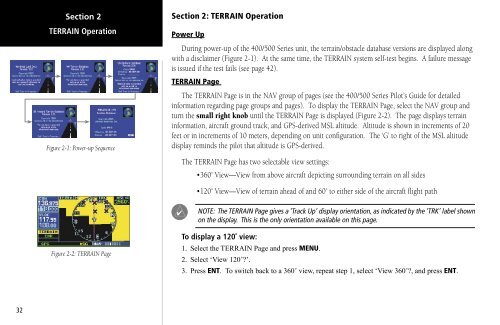
Figure 2-1: Power-up Sequence<br />
Figure 2-2: TERRAIN Page<br />
Section 2: TERRAIN Operation<br />
Power Up<br />
During power-up of the <strong>400</strong>/<strong>500</strong> <strong>Series</strong> unit, the terrain/obstacle database versions are displayed along<br />
with a disclaimer (Figure 2-1). At the same time, the TERRAIN system self-test begins. A failure message<br />
is issued if the test fails (see page 42).<br />
TERRAIN Page<br />
The TERRAIN Page is in the NAV group of pages (see the <strong>400</strong>/<strong>500</strong> <strong>Series</strong> Pilot’s Guide for detailed<br />
information regarding page groups and pages). To display the TERRAIN Page, select the NAV group and<br />
turn the small right knob until the TERRAIN Page is displayed (Figure 2-2). The page displays terrain<br />
information, aircraft ground track, and GPS-derived MSL altitude. Altitude is shown in increments of 20<br />
feet or in increments of 10 meters, depending on unit configuration. The ‘G’ to right of the MSL altitude<br />
display reminds the pilot that altitude is GPS-derived.<br />
The TERRAIN Page has two selectable view settings:<br />
•360˚ View—View from above aircraft depicting surrounding terrain on all sides<br />
•120˚ View—View of terrain ahead of and 60˚ to either side of the aircraft flight path<br />
NOTE: The TERRAIN Page gives a ‘Track Up’ display orientation, as indicated by the ‘TRK’ label shown<br />
on the display. This is the only orientation available on this page.<br />
To display a 120˚ view:<br />
1. Select the TERRAIN Page and press MENU.<br />
2. Select ‘View 120˚?’.<br />
3. Press ENT. To switch back to a 360˚ view, repeat step 1, select ‘View 360˚?, and press ENT.