12: Adjunct Proceedings - Automotive User Interfaces and ...
12: Adjunct Proceedings - Automotive User Interfaces and ...
12: Adjunct Proceedings - Automotive User Interfaces and ...

Create successful ePaper yourself
Turn your PDF publications into a flip-book with our unique Google optimized e-Paper software.
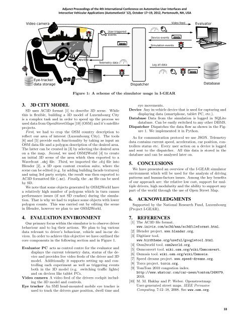
Video camera<br />
Markam<br />
Eye-tracker<br />
data storage<br />
Spec I<br />
<strong>Adjunct</strong> <strong>Proceedings</strong> of the 4th International Conference on <strong>Automotive</strong> <strong>User</strong> <strong>Interfaces</strong> <strong>and</strong><br />
Interactive Vehicular Applications (<strong>Automotive</strong>UI '<strong>12</strong>), October 17–19, 20<strong>12</strong>, Portsmouth, NH, USA<br />
Device<br />
<strong>User</strong>-triggered<br />
events<br />
Telemetry data<br />
3. 3D CITY MODEL<br />
SD uses AC3D format [1] to describe 3D scene. While<br />
this is flexible, building a 3D model of Luxembourg City<br />
is a complex task <strong>and</strong> in order to speed up the process we<br />
used data from OpenStreetMaps [10] (OSM) <strong>and</strong> it’s satellite<br />
projects.<br />
First, we had to crop the OSM country description to<br />
reflect our area of interest (Luxembourg City). The tools<br />
[6] <strong>and</strong> [5] provide such functionality by taking as input an<br />
OSM data file <strong>and</strong> a polygon description of the desired area.<br />
The latter can be created in [3] by selecting the desired area<br />
on a the map. Second, we used OSM2World [4] to create<br />
an initial 3D scene of the area which then exported to a<br />
Wavefront .obj file. Third, we imported the .obj file into<br />
Blender [2], a 3D open content creation suite, where the<br />
scene can be edited (e.g. by adding building facade textures)<br />
<strong>and</strong> using 3rd party scripts, the result was then exported to<br />
AC3D formatted file (.ac). Finally, the .ac file can be used<br />
by SD.<br />
We note that some objects generated by OSM2World have<br />
a relatively high number of polygons which in turn causes<br />
performance issues (if not SD crashes) during the simulation.<br />
That is why we had to replace some objects with lower<br />
polygon counts. This was carried out by editing the scene<br />
in Blender, however we plan to use OSM2World.<br />
4. EVALUATION ENVIRONMENT<br />
Our primary focus within the simulator is to observe driver<br />
behaviour <strong>and</strong> to log their actions. We plan to log various<br />
data relevant to driver’s behaviour, vehicle <strong>and</strong> in-car devices.<br />
In order to achieve this objective we have outlined the<br />
core components in the following section <strong>and</strong> in Figure 1.<br />
Evaluator PC acts as control centre for the evaluator <strong>and</strong><br />
displays the current telemetry data, status of the device<br />
<strong>and</strong> provides live video feeds of the driver <strong>and</strong> 3D<br />
model. Additionally it supports setting up <strong>and</strong> controlling<br />
each experiment as well as triggering events<br />
both in the 3D model (e.g. switching tra c lights)<br />
<strong>and</strong> on devices like tablet PCs.<br />
Video camera A video feed of the drivers cockpit including<br />
the 3D model <strong>and</strong> controls.<br />
Eye tracker An SMI head-mounted mobile eye tracker is<br />
used to track the drivers gaze position, dwell time <strong>and</strong><br />
Are you sure?<br />
yes no<br />
Dispatcher<br />
Are you sure?<br />
yes no<br />
Device events<br />
Simulation events<br />
Log all data<br />
Figure 1: A scheme of the simulator usage in I-GEAR<br />
Video feed<br />
Are you sure?<br />
yes no<br />
Evaluator<br />
Database<br />
eye movements.<br />
Device Any in-vehicle device that is used for capturing <strong>and</strong><br />
displaying data (smartphone, tablet PC, etc.).<br />
Database Data from the simulation is logged in SQLite<br />
database. Can be easily switched to any other DBMS.<br />
Dispatcher Dispatches the data flow as shown in the Figure<br />
1. We implemented it in Python.<br />
As for communication protocol we use JSON. Telemetry<br />
data contains current speed, acceleration, car position, controllers<br />
status etc. Every user action on a device is logged<br />
<strong>and</strong> sent to the dispatcher. All this data is stored in the<br />
database <strong>and</strong> can be analysed later on.<br />
5. CONCLUSIONS<br />
We have presented an overview of the I-GEAR simulator<br />
environment which will be used for the analysis of driving<br />
patterns <strong>and</strong> human-factors issues. Among the key benefits<br />
of our approach are: the relative low cost, support for multiple<br />
drivers, high modularity <strong>and</strong> the ability to support any<br />
part of the world through the use of Open Street Map.<br />
6. ACKNOWLEDGMENTS<br />
Supported by the National Research Fund, Luxembourg<br />
(Project I-GEAR).<br />
7. REFERENCES<br />
[1] The AC3D file format.<br />
www.inivis.com/ac3d/man/ac3dfileformat.html.<br />
[2] Blender project. www.blender.org.<br />
[3] Digitizer tool.<br />
www.birdtheme.org/useful/googletool.html.<br />
[4] Osm2world tool. osm2world.org.<br />
[5] Osmconvert tool. wiki.osm.org/wiki/Osmconvert.<br />
[6] Osmosis tool. wiki.osm.org/wiki/Osmosis.<br />
[7] Speed dreams project. www.speed-dreams.org.<br />
[8] Torcs project. torcs.org.<br />
[9] TomTom 2010 congestion index.<br />
http://www.whatcar.com/car-news/tomtom/249079,<br />
2010.<br />
[10] M. M. Haklay <strong>and</strong> P. Weber. Openstreetmap:<br />
<strong>User</strong>-generated street maps. IEEE Pervasive<br />
Computing, 7:<strong>12</strong>–18, 2008. See www.osm.org.<br />
33