- Page 1 and 2:
NATURAL RESOURCE INVENTORY REPORT O
- Page 3 and 4:
ABBREVIATIONS FIMS Fiji Islands Met
- Page 5 and 6:
TABLE OF CONTENTS ACKNOWLEDGEMENTS
- Page 7 and 8:
DEFINITIONS 1 : CHAPTER 3 1. Closed
- Page 9 and 10:
CHAPTER 3: LAND RESOURCES INVENTORY
- Page 11 and 12:
Map 3.1: Physical Geography of Viti
- Page 13 and 14:
3.2 SOILS OF FIJI Studies confirm t
- Page 15 and 16:
Table 3.4: Forest Area Derived From
- Page 17 and 18:
Map 3.2: Forest Cover of Fiji Sourc
- Page 19 and 20:
Table 3.7 shows areas of various fo
- Page 21 and 22:
Goshawk (Accipiter rufitorques). Fr
- Page 23 and 24:
Forests of Taveuni The upland fores
- Page 25 and 26:
Table 3.12: Fijian Endemic Land Sna
- Page 27 and 28:
discovery. Additionally, Barker (20
- Page 29 and 30:
1987, Paine et al. 1994) and is com
- Page 31 and 32:
Table 3.14: Numbers of ―Fijian‖
- Page 33 and 34:
Figure 3.4: Photograph of a living
- Page 35 and 36:
Figure 3.6: Photograph of an endemi
- Page 37 and 38:
ORDER BLATTODEA Family BLABERIDAE D
- Page 39 and 40:
Tricorynus herbarius (Gorham), 1883
- Page 41 and 42:
Stenorhis promus Jordan, 1937 psomu
- Page 43 and 44:
Undetermined Genus & species Cyphag
- Page 45 and 46:
pyroglypta Fairmaire, 1877 pyrura F
- Page 47 and 48:
Batocera nebulosa Bates, 1877 Cacod
- Page 49 and 50:
pinguis Thomson [nomen nudum; Schme
- Page 51 and 52:
thawathi Dillon & Dillon, 1952 thol
- Page 53 and 54:
Bruchus pisorum (Linnaeus), 1758 [D
- Page 55 and 56:
ugosa callosa Gressitt in Bryant &
- Page 57 and 58:
vermiculata Gressitt in Bryant & Gr
- Page 59 and 60:
transversalis Fabricius, 1781; repa
- Page 61 and 62:
Amblycnemis sp. [Zimmerman, 1956] A
- Page 63 and 64:
fijianus (Schedl), 1951 [Ozopemon]
- Page 65 and 66:
Ficicis porcatus (Chapuis), 1869 [H
- Page 67 and 68:
angulata Zimmerman, 1936 ater Zimme
- Page 69 and 70:
tenuis Browne, 1984 [from Lund Coll
- Page 71 and 72:
fijianus (Schedl), 1938 [Xyleborus]
- Page 73 and 74:
Conobajulus ugiensis Van Zwaluwenbe
- Page 75 and 76:
Fornax anchastoides Fleutiaux, 1932
- Page 77 and 78:
Coelofletium coelostomoides (Balfou
- Page 79 and 80:
puncticollis Wittmer, 1983 savuraen
- Page 81 and 82:
decolor (Fairmaire), 1849 [Nacerdes
- Page 83 and 84:
Monteitheolus fijiensis Howden & St
- Page 85 and 86:
Cryptomorpha desjardinsi (Guérin-M
- Page 87 and 88:
nigriceps Cameron, 1926 Diestota al
- Page 89 and 90:
Lispinus praenobilis Bernhauer, 192
- Page 91 and 92:
Sternotropa brevicornis Cameron, 19
- Page 93 and 94:
Enneacoides vinculiger Fairmaire, 1
- Page 95 and 96:
Tagalus brevissimus Kaszab, 1955 br
- Page 97 and 98:
venusta Steinmann, 1985 Chaetospani
- Page 99 and 100:
Mesoleptogaster levusara Evenhuis,
- Page 101 and 102:
"costalis group sp. no. 2" [Dyce et
- Page 103 and 104:
striolata (Wiedemann), 1830 [Chloro
- Page 105 and 106:
kilaka Bickel, 2009 kotoi Bickel, 2
- Page 107 and 108:
Family DROSOPHILIDAE Dettopsomyia f
- Page 109 and 110:
Nostima sp. — [from BPBM collecti
- Page 111 and 112:
Undetermined genus sp. — [N. Even
- Page 113 and 114:
kraussi Alexander, 1956 pietatis Al
- Page 115 and 116:
sp. [FNIC collection] Family MILICH
- Page 117 and 118:
greenwoodi (Edwards), 1924 [Delopsi
- Page 119 and 120:
Meringomeria neurostigma (Bezzi), 1
- Page 121 and 122:
pacifica Edwards, 1924 Plastosciara
- Page 123 and 124:
Sphaerofijia evazaeformis Bezzi, 19
- Page 125 and 126:
Blepharipa sp. — [from BPBM colle
- Page 127 and 128:
Sipholeskia ignifrons Bezzi, 1928 S
- Page 129 and 130:
Family TIPULIDAE Holorusia damuda E
- Page 131 and 132:
fungicola (Kirkaldy), 1908 [Ctenone
- Page 133 and 134:
Peltoscytus klysi Lis, 1993 Family
- Page 135 and 136:
Nesostethus bipartitus Scudder, 198
- Page 137 and 138:
ovatus (Herczek), 1991 [Isometopus]
- Page 139 and 140:
laaevis Bergroth, 1894 Piezodorus r
- Page 141 and 142:
[Plociomerus] Pseudopachybrachius g
- Page 143 and 144:
fosteri Andersen, 1989 Microvelia p
- Page 145 and 146:
vitiensis (Kirkaldy), 1906 [Cicadul
- Page 147 and 148:
corynetus corynetus Duffels, 1977 c
- Page 149 and 150:
Latistria eupompe (Kirkaldy), 1907
- Page 151 and 152:
clitoria Fennah, 1950 coccinea Muir
- Page 153 and 154:
camilla kanduvuana Fennah, 1950 cli
- Page 155 and 156:
Dialeurodes greenwoodi Corbett, 193
- Page 157 and 158:
Pulvinaria psidii Maskell, 1893 urb
- Page 159 and 160:
tokionus (Kuwana), 1902: 81 [Mytila
- Page 161 and 162:
Paracoccus dendricola Williams & Wa
- Page 163 and 164:
Pleistodontes greenwoodi (Grandi),
- Page 165 and 166:
lackburni Cameron, 1881 rugulosus L
- Page 167 and 168:
sp. [Schmeltz, 1866] Dirhinus giffa
- Page 169 and 170:
Aenasius advena Compere, 1937 Anagy
- Page 171 and 172:
Thripastichus thripophonus Watersto
- Page 173 and 174:
maudella Mann 1921 maudella seemann
- Page 175 and 176:
Pachycondyla stigma (Fabricius), 18
- Page 177 and 178:
wheeleri Mann, 1921 Tapinoma melano
- Page 179 and 180:
dolosus (Tosquinet), 1896 [Ophion];
- Page 181 and 182:
sp. 2 [Bennett, 2009] sp. 3 [Bennet
- Page 183 and 184:
sp. [J. Huber, in litt.] Camptopter
- Page 185 and 186:
calandrae (Howard), 1881 [Pteromalu
- Page 187 and 188:
atra (Kieffer) [L. Masner, in litt.
- Page 189 and 190:
impetuosa (Smith), 1861 [Icaria]; s
- Page 191 and 192:
Undetermined Genus sp. [Dugdale, 19
- Page 193 and 194:
Acritocera negligens Butler, 1886 F
- Page 195 and 196:
glauculalis (Guenée), 1854 [Margar
- Page 197 and 198:
Lygropispha eoxantha Meyrick, 1933
- Page 199 and 200:
Rehimena infundibulalis (Snellen va
- Page 201 and 202:
lipara Bradley, 1953 Pectinophora g
- Page 203 and 204:
samoana fijiensis Robinson, 1975 sa
- Page 205 and 206:
Maxates albifulgens (Prout), 1934 [
- Page 207 and 208:
Symmacra solidaria baptata (Warren)
- Page 209 and 210:
Hasora chromus bilunata (Butler), 1
- Page 211 and 212:
Calliteara fidjiensis (Mabille & Vu
- Page 213 and 214:
signata (Fabricius), 1792 [Noctua]
- Page 215 and 216:
Dichromia quinqualis Walker, 1859 t
- Page 217 and 218:
Harita nodyna (Bethune-Baker), 1908
- Page 219 and 220:
Microthripa buxtoni Tams, 1935 Mnio
- Page 221 and 222:
jocosatrix Guenée, 1852 magnifica
- Page 223 and 224:
festiva (Donovan), 1805 [Phalaena]
- Page 225 and 226:
menippe Hübner, 1816 [as plexippus
- Page 227 and 228:
Pseudaegeria squamicornis (Felder &
- Page 229 and 230:
zelimalis Walker, 1859 itysalis Wal
- Page 231 and 232:
Diasemiopsis ramburialis Duponchel,
- Page 233 and 234:
ardua Swinhoe, 1902; drucei Bethune
- Page 235 and 236:
nigricostalis (Walker), 1863 [Trach
- Page 237 and 238:
hirundo samoanum Rothschild & Jorda
- Page 239 and 240:
utella Zeller, 1852 Tinea chlorospo
- Page 241 and 242:
Tortrix leucocharis Meyrick, 1933 T
- Page 243 and 244:
Family SISYRIDAE Sisyra palmata New
- Page 245 and 246:
eurybia (Sélys-Longchamps), 1878 [
- Page 247 and 248:
configens Otte & Cowper in Otte, 20
- Page 249 and 250:
africana Palisot de Beauvois, 1805
- Page 251 and 252:
lutescens Walker, 1869 nitida (Redt
- Page 253 and 254:
incisus (Piaget), 1880 [Colpocephal
- Page 255 and 256:
vitiensis Thornton, 1981 Lepidopsoc
- Page 257 and 258:
mara Thornton, 1981 marostica Thorn
- Page 259 and 260:
magnus Moulton, 1944 Haplothrips go
- Page 261 and 262:
Elixothrips brevisetus (Bagnall), 1
- Page 263 and 264:
moselyi Oláh & Barnard in Oláh, J
- Page 265 and 266:
or dry zone. Montane forest is a re
- Page 267 and 268:
11 Ruppiaceae 1 12 Cymodoceaceae 3
- Page 269 and 270:
99 Turneraceae 1 100 Passifloraceae
- Page 271 and 272:
32; 187 Orchidaceae 169 188 Phormia
- Page 273 and 274:
26 Ophioglossaceae Ophioglossum ret
- Page 275 and 276:
80 Hymenophyllaceae Trichomanes den
- Page 277 and 278:
134 Vittariaceae Antrophyum smithii
- Page 279 and 280:
188 Arthyriaceae Diplazium harpeode
- Page 281 and 282:
242 Aspidiaceae Pleocnemia irregula
- Page 283 and 284:
296 Polypodiaceae Microsorium punct
- Page 285 and 286:
22. Alismataceae Sagittaria sagitti
- Page 287 and 288:
76. Musaceae Musa troglodytarum L.
- Page 289 and 290:
129. Cyperaceae Cyperus haspan L. E
- Page 291 and 292:
183. Poaceae Cynodon dactylon (L.)
- Page 293 and 294:
237. Poaceae Oplismenus imbecillis
- Page 295 and 296:
291. Poaceae Zea mays L. Exotic 292
- Page 297 and 298:
345. Araceae Epiprenum pinnatum cv.
- Page 299 and 300:
399. Annonaceae Cananga odorata (La
- Page 301 and 302:
453. Peperomiaceae Peperomia attenu
- Page 303 and 304:
507. Ceratophyllaceae Ceratophyllum
- Page 305 and 306:
561. Urticaceae Elatostema tenellum
- Page 307 and 308:
615. Amaranthaceae Amaranthus hybri
- Page 309 and 310:
669. Elaeocarpaceae Elaeocarpus sub
- Page 311 and 312:
723. Malvaceae Abelmoshus moschatus
- Page 313 and 314:
777. Euphorbiaceae Glochidion colli
- Page 315 and 316:
831. Euphorbiaceae Croton metallicu
- Page 317 and 318:
885. Flacourtiaceae Flacourtia dege
- Page 319 and 320:
939. Capparaceae Capparis quiniflor
- Page 321 and 322:
993. Sapotaceae Palaquium fidjiense
- Page 323 and 324:
1047. Cunoniaceae 1 Weinmannia viti
- Page 325 and 326:
1101. Caesalpiniaceae 7 Caesalpinia
- Page 327 and 328:
1155. Fabaceae 1 Andira inermis (Wr
- Page 329 and 330:
1209. Fabaceae 1 Macropsychanthus l
- Page 331 and 332:
1263. Fabaceae 2 Crotalaria juncea
- Page 333 and 334:
1317. Myrtaceae 2 Syzygium corynoca
- Page 335 and 336:
1365. Melastomataceae 3 Medinella l
- Page 337 and 338:
1419. Anacardiaceae 3 Pistacia chin
- Page 339 and 340:
1472. Meliaceae 4 Azadirachta indic
- Page 341 and 342:
1526. Sapindaceae 4 Elattostachys v
- Page 343 and 344:
1580. Dichapetalaceae 5 Dichapetalu
- Page 345 and 346:
1634. Apocynaceae 2 Neisosperma opp
- Page 347 and 348:
1688. Oleaceae 7 Jasminum betchei F
- Page 349 and 350:
1742. Rubiaceae 1 Ixora pelagica Se
- Page 351 and 352:
1796. Rubiaceae 1 Psychotria prismo
- Page 353 and 354:
1850. Rubiaceae 2 Psychotria bracke
- Page 355 and 356:
1904. Solanaceae 2 Datura stramoniu
- Page 357 and 358:
1958. Scrophulariaceae 7 Limnophila
- Page 359 and 360:
2012. Acanthaceae 1 Cuscuta campest
- Page 361 and 362:
2066. Verbenaceae 1 Faradaya vitien
- Page 363 and 364:
2120. Asteraceae 2 Eclipta prostrat
- Page 365 and 366:
2174. Orchidaceae 2 Peristylus novo
- Page 367 and 368:
2228. Orchidaceae 3 Dendrobium vaga
- Page 369 and 370:
2282. Orchidaceae 3 Bulbophyllum tr
- Page 371 and 372:
2336. Phormiaceae 4 Dianella adenan
- Page 373 and 374:
48. Asteraceae Centratherum punctat
- Page 375 and 376:
102. 103. 104. 105. 106. 107. 108.
- Page 377 and 378:
Table 3.21: CHECKLIST TO THE TREE S
- Page 379 and 380:
89 Cunoniaceae Geissois ternata var
- Page 381 and 382:
181 Loganiaceae Geniostoma spec.div
- Page 383 and 384:
273 Myrtaceae Syzygium quadrangulat
- Page 385 and 386:
365 Symplocaceae Symplocos leptophy
- Page 387 and 388:
69 Myrtaceae Syzygium decussatus Ya
- Page 389 and 390:
game. The conservation status for M
- Page 391 and 392:
Figure 3.8: Map of areas surveyed a
- Page 393 and 394:
Figure 3.10: The ground cover of th
- Page 395 and 396:
Figure 3.12: Male Friendly Ground D
- Page 397 and 398:
Discussion Makodraga and Makogai Is
- Page 399 and 400:
Figure 3.15 Woody lianas and short
- Page 401 and 402:
Caesalpiniaceae Cynometra falcata E
- Page 403 and 404:
3.13 INTRODUCED SPECIES An introduc
- Page 405 and 406:
Indian myna (Acridotheres tristis).
- Page 407 and 408:
23% endemism (McGinley, 2007). Some
- Page 409 and 410:
3.21 CONCLUSION In this chapter I h
- Page 411 and 412:
3.22 BIBLIOGRAPHY Ajisaka, S., and
- Page 413 and 414:
Central Intelligence Agency. (2009)
- Page 415 and 416:
Fiji Pine Limited. (2006). Pine Pla
- Page 417 and 418:
Leslie, D.M. (1997). Soils of Fiji.
- Page 419 and 420:
Nature Fiji. (2010). Endangered Spe
- Page 421 and 422:
Smith, A.C. (1979). Flora Vitiensis
- Page 423 and 424:
Wells, J. (1977). A Preliminary Rep
- Page 425 and 426:
CONTACT LIST OF THE VARIOUS STAKEHO
- Page 427 and 428:
Birds of the Fiji Islands Dick Watl
- Page 429 and 430:
Eleven species have been introduced
- Page 431 and 432:
Centipedes and Millipedes of Fiji D
- Page 433 and 434:
Biodiversity of Fijian Land Snails
- Page 435 and 436:
Table 1. Land mammals of Fiji Pacif
- Page 437 and 438:
National Biodiversity Inventory for
- Page 439 and 440:
ACKNOWLEDGEMENT Many thanks to our
- Page 441 and 442:
INTRODUCTION Plant checklists are t
- Page 443 and 444:
7 14 Liliaceae 4 15 Alliaceae 2 16
- Page 445 and 446:
9 102 Cochlospermaceae 1 103 Cariac
- Page 448 and 449:
CHECKLIST TO THE FERNS OF FIJI No.
- Page 450 and 451:
56 Hymenophyllaceae Hymenophyllum p
- Page 452 and 453:
114 Davalliaceae Nephrolepis tubero
- Page 454 and 455:
172 Aspleniaceae Asplenium excisum
- Page 456 and 457:
230 Aspidiaceae Tectaria decurrens
- Page 458 and 459:
288 Polypodiaceae Pyrrosia blepharo
- Page 460 and 461:
25. Hydrocharitaceae Halophila mino
- Page 462 and 463:
83. Zingiberaceae Zingiber officina
- Page 464 and 465:
140. Cyperaceae Machaerina falcata
- Page 466 and 467:
198. Poaceae Zoysia japonica Steude
- Page 468 and 469:
256. Poaceae Pennisetum polystachyo
- Page 470 and 471:
314. Arecaceae Archontophoenix alex
- Page 472 and 473:
372. Pandanaceae Pandanus gillespie
- Page 474 and 475:
429. Peperomiaceae Peperomia nodosa
- Page 476 and 477:
487. Lauraceae Cryptocarya turrilli
- Page 478 and 479:
545. Moraceae Malaisia scandens (Lo
- Page 480 and 481:
603. Portulacaceae Portulaca olerac
- Page 482 and 483:
661. Elaeocarpaceae Elaeocarpus kas
- Page 484 and 485:
719. Malvaceae Hibiscus schizopetal
- Page 486 and 487:
777. Euphorbiaceae Glochidion colli
- Page 488 and 489:
835. Euphorbiaceae Omalanthus nutan
- Page 490 and 491:
893. Flacourtiaceae Casearia myrsin
- Page 492 and 493:
951. Brassicaceae Lobularia maritim
- Page 494 and 495:
1009. 6 Myrsinaceae Maesa vitiensis
- Page 496 and 497:
1067. 3 Mimosaceae Adenathera pavon
- Page 498 and 499:
1125. 9 Caesalpiniaceae Senna multi
- Page 500 and 501:
1183. 1 Fabaceae Dendrobium umbella
- Page 502 and 503:
1241. 2 Fabaceae Macroptilium lathy
- Page 504 and 505:
1299. 2 Myrtaceae Eucalyptus macula
- Page 506 and 507:
1354. 3 Myrtaceae Eugenia brasilien
- Page 508 and 509:
1412. 3 Anacardiaceae Magnifera ind
- Page 510 and 511:
1470. 4 Rutaceae Limonia acidissima
- Page 512 and 513:
1528. 4 Sapindaceae Cossignia pacif
- Page 514 and 515:
1586. 5 Rhamnaceae Ziziphus mauriti
- Page 516 and 517:
1644. 3 Apocynaceae Alstonia montan
- Page 518 and 519:
1702. 8 Rubiaceae Neolamarckia cada
- Page 520 and 521:
1760. 1 Rubiaceae Coffea liberica H
- Page 522 and 523:
1818. 2 Rubiaceae Psychotria incomp
- Page 524 and 525:
1876. 2 Rubiaceae Hedyotis biflora
- Page 526 and 527:
1934. 5 Convolvulaceae Ipomoea pes-
- Page 528 and 529:
1992. 1 Gesneriaceae Cyrtandra denh
- Page 530 and 531:
2050. 1 Verbenaceae Verbena brasili
- Page 532 and 533:
2108. 2 Asteraceae Elephantopus mol
- Page 534 and 535:
2166. 2 Asteraceae Emilia sonchifol
- Page 536 and 537:
2224. 3 Orchidaceae Coelogyne macdo
- Page 538 and 539:
2282. 3 Orchidaceae Bulbophyllum tr
- Page 540 and 541:
Preliminary checklist of recently i
- Page 542 and 543: 52. Asteraceae Wedelia trilobata (L
- Page 544 and 545: 110. Sapindaceae Filicium decipiens
- Page 546 and 547: CHECKLIST TO THE TREE SPECIES OF FI
- Page 548 and 549: 100 Elaeocarpaceae Elaeocarpus chel
- Page 550 and 551: 204 Meliaceae Dysoxylum gillespiean
- Page 552 and 553: 308 Rubiaceae Mastixiodendron robus
- Page 554 and 555: 23 Clusiaceae Garcinia myrtifolia B
- Page 556 and 557: INSTITUTE OF APPLIED SCIENCES THE U
- Page 558 and 559: RAPID BIODIVERSITY ASSESSMENT OF MA
- Page 560 and 561: is currently used as a picnic spot
- Page 562 and 563: Figure 1: Map of areas surveyed and
- Page 564 and 565: The survey two months later by P. H
- Page 566 and 567: Table 2: List of Land birds of Mako
- Page 568 and 569: Figure 7. Coastal Forest Type with
- Page 570 and 571: Discussion The Dry Forest vegetatio
- Page 572 and 573: Fabaceae Millettia pinnata Ind X X
- Page 574 and 575: Summary Report to Fiji Government D
- Page 576 and 577: Summary Report to Fiji Government D
- Page 578 and 579: Summary Report to Fiji Government D
- Page 580 and 581: Summary Report to Fiji Government D
- Page 582 and 583: Summary Report to Fiji Government D
- Page 584 and 585: Summary Report to Fiji Government D
- Page 586 and 587: The Forest Resources Assessment Pro
- Page 588 and 589: FRA 2010 - Country Report, Fiji Rep
- Page 590 and 591: FRA 2010 - Country Report, Fiji 1.2
- Page 594 and 595: FRA 2010 - Country Report, Fiji 2 T
- Page 596 and 597: FRA 2010 - Country Report, Fiji 2.3
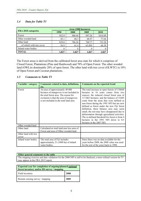
- Page 598 and 599: FRA 2010 - Country Report, Fiji Tab
- Page 600 and 601: FRA 2010 - Country Report, Fiji 3.2
- Page 602 and 603: FRA 2010 - Country Report, Fiji 3.4
- Page 604 and 605: FRA 2010 - Country Report, Fiji 4 T
- Page 606 and 607: FRA 2010 - Country Report, Fiji All
- Page 608 and 609: FRA 2010 - Country Report, Fiji 5 T
- Page 610 and 611: FRA 2010 - Country Report, Fiji 5.3
- Page 612 and 613: FRA 2010 - Country Report, Fiji 7 T
- Page 614 and 615: FRA 2010 - Country Report, Fiji 9 T
- Page 616 and 617: FRA 2010 - Country Report, Fiji 11
- Page 618 and 619: FRA 2010 - Country Report, Fiji 11.
- Page 620 and 621: FRA 2010 - Country Report, Fiji 13
- Page 622 and 623: FRA 2010 - Country Report, Fiji 14
- Page 624 and 625: FRA 2010 - Country Report, Fiji In
- Page 626 and 627: FRA 2010 - Country Report, Fiji Not
- Page 628 and 629: FRA 2010 - Country Report, Fiji 16.
- Page 630 and 631: FRA 2010 - Country Report, Fiji 17.