sr 60 “twin pairs” - City of Vero Beach
sr 60 “twin pairs” - City of Vero Beach
sr 60 “twin pairs” - City of Vero Beach

You also want an ePaper? Increase the reach of your titles
YUMPU automatically turns print PDFs into web optimized ePapers that Google loves.
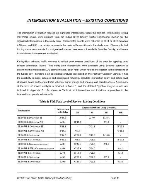
INTERSECTION EVALUATION – EXISTING CONDITIONS<br />
The intersection evaluation focused on signalized intersections within the corridor. Intersection turning<br />
movement counts were obtained from the Indian River County Traffic Engineering Division for the<br />
signalized intersections in the study area. These traffic counts were collected in 2011 or 2012 between<br />
4:00 p.m. and 5:00 p.m., which represents the peak traffic conditions in the study area. Please note that<br />
turning movements counts for unsignalized intersections were not available from the County, and hence<br />
those intersections were not evaluated.<br />
Kimley-Horn adjusted traffic volumes to reflect peak season conditions <strong>of</strong> the year by applying peak<br />
season conversion factors. The study area intersections were analyzed using Synchro s<strong>of</strong>tware to<br />
determine the intersection LOS during the p.m. peak hour, which reflects the highest traffic conditions <strong>of</strong><br />
the typical day. Synchro is an operational analysis tool based on the Highway Capacity Manual. It has<br />
the capability to model actuated and coordinated networks, calculate intersection delay, and define level<br />
<strong>of</strong> service based on the input traffic volumes, signal timings and phasing, and corridor <strong>of</strong>fsets. A summary<br />
<strong>of</strong> the level <strong>of</strong> service analysis is provided in Table 3, and the detailed Synchro analysis results are<br />
included in Appendix B. As shown in Table 4, all intersections and individual approaches to the<br />
intersections operate satisfactorily.<br />
Intersection<br />
Table 4: P.M. Peak Level <strong>of</strong> Service - Existing Conditions<br />
Intersection<br />
LOS/Delay<br />
Approach LOS and Delay (seconds)<br />
NB SB EB WB<br />
SR <strong>60</strong> EB & 20 Avenue SB B/14.5 - A/7.0 B/16.4 -<br />
SR <strong>60</strong> EB & 20 Avenue NB A/9.4 D/41.5 - A/0.1 -<br />
SR <strong>60</strong> WB & 20 Avenue SB B/18.8 - D/51.8 - B/12.3<br />
SR <strong>60</strong> WB & 20 Avenue NB B/18.9 A/1.6 - - C/21.3<br />
SR <strong>60</strong> EB & 14 Avenue B/14.5 C/21.6 B/19.3 B/10.5 -<br />
SR <strong>60</strong> WB & 14 Avenue B/19.2 A/9.5 C/29.6 - B/17.3<br />
SR <strong>60</strong> EB & Commerce Avenue A/3.1 C/25.1 C/20.5 A/1.2 -<br />
SR <strong>60</strong> WB & US 1/Commerce Avenue A/6.6 C/27.9 C/24.0 - A/4.1<br />
SR <strong>60</strong> WB & 11 Avenue A/7.8 B/18.8 C/22.6 - A/4.8<br />
SR <strong>60</strong> EB & 10 Avenue A/9.2 C/22.3 C/20.8 A/5.1 -<br />
SR <strong>60</strong> WB & 10 Avenue A/9.9 C/20.1 C/22.1 - A/3.9<br />
SR <strong>60</strong> “Twin Pairs” Traffic Calming Feasibility Study Page 11