GEOLOGY OF THE PENGKALAN HULU-BETONG TRANSECT ...
GEOLOGY OF THE PENGKALAN HULU-BETONG TRANSECT ...
GEOLOGY OF THE PENGKALAN HULU-BETONG TRANSECT ...
Create successful ePaper yourself
Turn your PDF publications into a flip-book with our unique Google optimized e-Paper software.
x<br />
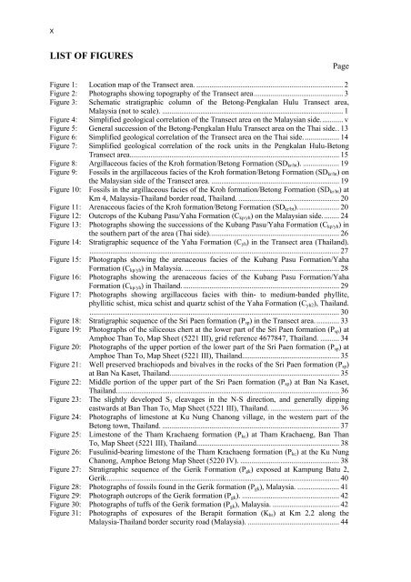
LIST <strong>OF</strong> FIGURES<br />
Page<br />
Figure 1: Location map of the Transect area. ............................................................................. 2<br />
Figure 2: Photographs showing topography of the Transect area............................................... 3<br />
Figure 3: Schematic stratigraphic column of the Betong-Pengkalan Hulu Transect area,<br />
Malaysia (not to scale). ............................................................................................... 1<br />
Figure 4: Simplified geological correlation of the Transect area on the Malaysian side............ v<br />
Figure 5: General succession of the Betong-Pengkalan Hulu Transect area on the Thai side.. 13<br />
Figure 6: Simplified geological correlation of the Transect area on the Thai side. .................. 14<br />
Figure 7: Simplified geological correlation of the rock units in the Pengkalan Hulu-Betong<br />
Transect area.............................................................................................................. 15<br />
Figure 8: Argillaceous facies of the Kroh formation/Betong Formation (SDkr/bt). ................... 19<br />
Figure 9: Fossils in the argillaceous facies of the Kroh formation/Betong Formation (SDkr/bt) on<br />
the Malaysian side of the Transect area. ................................................................... 19<br />
Figure 10: Fossils in the argillaceous facies of the Kroh formation/Betong Formation (SDkr/bt) at<br />
Km 4, Malaysia-Thailand border road, Thailand. ..................................................... 20<br />
Figure 11: Arenaceous facies of the Kroh formation/Betong Formation (SDkr/bt)...................... 20<br />
Figure 12: Outcrops of the Kubang Pasu/Yaha Formation (Ckp/yh) on the Malaysian side......... 24<br />
Figure 13: Photographs showing the successions of the Kubang Pasu/Yaha Formation (Ckp/yh) in<br />
the southern part of the area (Thai side).................................................................... 26<br />
Figure 14: Stratigraphic sequence of the Yaha Formation (Cyh) in the Transect area (Thailand).<br />
................................................................................................................................... 27<br />
Figure 15: Photographs showing the arenaceous facies of the Kubang Pasu Formation/Yaha<br />
Formation (Ckp/yh) in Malaysia. ................................................................................. 28<br />
Figure 16: Photographs showing the arenaceous facies of the Kubang Pasu Formation/Yaha<br />
Formation (Ckp/yh) in Thailand................................................................................... 29<br />
Figure 17: Photographs showing argillaceous facies with thin- to medium-banded phyllite,<br />
phyllitic schist, mica schist and quartz schist of the Yaha Formation (Cyh2), Thailand.<br />
................................................................................................................................... 30<br />
Figure 18: Stratigraphic sequence of the Sri Paen formation (Psp) in the Transect area............. 33<br />
Figure 19: Photographs of the siliceous chert at the lower part of the Sri Paen formation (Psp) at<br />
Amphoe Than To, Map Sheet (5221 III), grid reference 4677847, Thailand. .......... 34<br />
Figure 20: Photographs of the upper portion of the lower part of the Sri Paen formation (Psp) at<br />
Amphoe Than To, Map Sheet (5221 III), Thailand................................................... 35<br />
Figure 21: Well preserved brachiopods and bivalves in the rocks of the Sri Paen formation (Psp)<br />
at Ban Na Kaset, Thailand......................................................................................... 35<br />
Figure 22: Middle portion of the upper part of the Sri Paen formation (Psp) at Ban Na Kaset,<br />
Thailand..................................................................................................................... 36<br />
Figure 23: The slightly developed S1 cleavages in the N-S direction, and generally dipping<br />
eastwards at Ban Than To, Map Sheet (5221 III), Thailand. .................................... 36<br />
Figure 24: Photographs of limestone at Ku Nung Chanong village, in the western part of the<br />
Betong town, Thailand. ............................................................................................. 37<br />
Figure 25: Limestone of the Tham Krachaeng formation (Pkc) at Tham Krachaeng, Ban Than<br />
To, Map Sheet (5221 III), Thailand........................................................................... 38<br />
Figure 26: Fusulinid-bearing limestone of the Tham Krachaeng formation (Pkc) at the Ku Nung<br />
Chanong, Amphoe Betong Map Sheet (5220 IV). .................................................... 38<br />
Figure 27: Stratigraphic sequence of the Gerik Formation (Pgk) exposed at Kampung Batu 2,<br />
Gerik.......................................................................................................................... 40<br />
Figure 28: Photographs of fossils found in the Gerik formation (Pgk), Malaysia. ...................... 41<br />
Figure 29: Photograph outcrops of the Gerik formation (Pgk). ................................................... 42<br />
Figure 30: Photographs of tuffs of the Gerik formation (Pgk), Malaysia. ................................... 42<br />
Figure 31: Photographs of exposures of the Berapit formation (Kbr) at Km 2.2 along the<br />
Malaysia-Thailand border security road (Malaysia). ................................................ 44


