PERTH, FRIDAY, 5 JULY 1991 No. 87 - State Law Publisher - The ...
PERTH, FRIDAY, 5 JULY 1991 No. 87 - State Law Publisher - The ...
PERTH, FRIDAY, 5 JULY 1991 No. 87 - State Law Publisher - The ...
You also want an ePaper? Increase the reach of your titles
YUMPU automatically turns print PDFs into web optimized ePapers that Google loves.
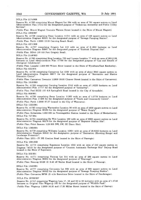
3342 GOVERNMENT GAZETTE, WA [5 July <strong>1991</strong><br />
DOLA File 2174,988<br />
Reserve <strong>No</strong>. 41785 comprising Mount Magnet Lot 564 with an area of 761 square metres on Land<br />
Administration Plan 17012 for the designated purpose of "Pedestrian Accessway and Public Utility<br />
Services".<br />
Public Plan: Mount Magnet Townsite Watson Street located in the Shire of Mount Magnet.<br />
DOLA File 1056/9<strong>87</strong><br />
Reserve <strong>No</strong>. 41708 comprising Swan Location 11311 with an area of 120 square metres on Land<br />
Administration Diagram 89351 for the designated purpose of "Sewage Pumping Station".<br />
Public Plan: Perth 1:2000 12:19 Canning Beach Road.<br />
DOLA File 407 1,989<br />
Reserve <strong>No</strong>. 41737 comprising Gregory Lot 210 with an area of 8.1802 hectares on Land<br />
Administration Diagram 89967 for the designated purpose of "Rubbish Disposal Site".<br />
Public Plan: BD44 10 6.8 Port Gregory Road.<br />
DOLA File 2 149/983<br />
Reserve <strong>No</strong>. 41765 comprising King Location 730 and Luman Location 77 with an area of 200.2106<br />
hectares on Land Administration Plan 17790 for the designated purpose of "Use and Benefit of<br />
Aboriginal Inhabitants".<br />
Public Plan: Lissadel 1:250 000 Wilson River located in the Shire of Wyndham/East Kimberley.<br />
DOLA File 832/975<br />
Reserve <strong>No</strong>. 41756 comprising Carnarvon Lot 1300 with an area of about 9045 square metres on<br />
Land Administration Diagram 89<strong>87</strong>7 for the designated purpose of "Recreation and Marine<br />
Education Centre".<br />
Public Plan: Carnarvon Townsite 1:2000 08.05 Cleaver Street located in the Shire of Carnarvon.<br />
DOLA File 1916/990<br />
Reserve <strong>No</strong>. 41782 comprising Canning Location 3742 with an area of 1.6230 hectares on Land<br />
Administration Plan 17777 for the designated purpose of "Accessway".<br />
Public Plan: Peel BG33 10 6.8 Springfield Road located in theCity of Armadale.<br />
DOLA File 936/991<br />
Reserve <strong>No</strong>. 41766 comprising Swan Location 11265 with an area of 1.0778 hectares on Land<br />
Administration Plan 17488 for the designated purpose of "Youth and Community Centre".<br />
Public Plan: Perth 1:2000 07.37 located in the City of Wanneroo.<br />
DOLA File 1330/991<br />
Reserve <strong>No</strong>. 41763 comprising Warramboo Location 56 with an area of 1939 square metres on Land<br />
Administration Diagram 88160 for the designated purpose of "Water Supply".<br />
Public Plan: Kirkalocka 1:250 000 on Yoweragabbie Station located in the Shire of Meekatharra.<br />
DOLA File 727/984<br />
Reserve <strong>No</strong>. 41764 comprising De Witt Location 189 with an area of 9998 square metres on Land<br />
Administration Diagram 88276 for the designated purpose of "Repeater Station Site".<br />
Public Plan: Point Samson 1:25 000 NW, SW, SE Dixon Site.<br />
DOLA File 1389/991<br />
Reserve <strong>No</strong>. 41779 comprising Williams Location 15801 with an area of 20.8225 hectares on Land<br />
Administration Diagram 90040 for the designation purpose of "Recreation Shooting Range and<br />
Landscape Protection".<br />
Public Plan: 2331-IV NE Contine Road located in the Shire of Narrogin<br />
DOLA File <strong>1991</strong>/968<br />
Reserve <strong>No</strong>. 41773 comprising Esperance Location 1922 with an area of 240 square metres on<br />
Diagram 74019 for the designated purpose of "Country Automatic Exchange Site" Dalyup Road<br />
located in the Shire of Esperance.<br />
DOLA File 505/99 1<br />
Reserve <strong>No</strong>. 41771 comprising Nannup Lot 314 with an area of 280 square metres on Land<br />
Administration Diagram 89852 for the designated purpose of "Drainage".<br />
Public Plan: Nannup BG28 2 9.40 off Walter Road located in the Shire of Nannup.<br />
DOLA File 1349/99 1<br />
Reserve <strong>No</strong>. 41777 comprising Cervantes Lot 862 with an area of 682 square metres on Land<br />
Administration Diagram 90022 for the designated purpose of "Sewage Pumping Station".<br />
Public Plan: Cervantes BF38 2 4.24 Barcelona Drive located in the Shire of Dandaragan.<br />
DOLA File 10709/907<br />
Reserve <strong>No</strong>. 41747 comprising Wagerup Lots 17, 18 and 22 to 25 inclusive with an area of 1.2749<br />
hectares on Original Plan Wagerup 185 for the designated purpose of "Wildlife Park".<br />
Public Plan: Wagerup 1:2000 16.35 and 17.35 Millar Street located in the Shire of Harvey.


