

Phase I - Halifax Regional Municipality
Phase I - Halifax Regional Municipality
Phase I - Halifax Regional Municipality

You also want an ePaper? Increase the reach of your titles
YUMPU automatically turns print PDFs into web optimized ePapers that Google loves.
Archaeological Resource Impact Assessment<br />
Pre-development Assessment<br />
Spring Garden Road/Queen Street Public Lands Plan<br />
The detail of the ordinance sketch does not reveal any throughway or rudimentary road<br />
representing Dundonald Street to compliment Jackson’s map or the 1762 Crown Lands<br />
map, but this is not surprising since the artists may not have viewed such a feature as<br />
ordinance property.<br />
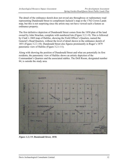
The first definitive depiction of Dundonald Street comes from the 1850 plan of the land<br />
owned by John Strachan, complete with numbered lots (Figure 3.2.1-9). This is followed<br />
by Clark’s 1869 map of <strong>Halifax</strong>, showing the Field Officer’s Quarters, named the<br />
General’s Head Quarters, without the level of detail shown in the ordinance sketch of<br />
1851 (Figure 3.2.1-10). Dundonald Street also figures prominently in Ruger’s 1879<br />
panoramic view of <strong>Halifax</strong> (Figure 3.2.1-11).<br />
Along with showing the position of Dundonald Street and what are potentially its first<br />
residents, the panoramic view of <strong>Halifax</strong> shows an artistic depiction of the<br />
Commandant’s Quarters and the associated stables. The Drill Room, designated number<br />
84, is outside the study area.<br />
Figure 3.2.1-9: Dundonald Street, 1850.<br />
Davis Archaeological Consultants Limited 12


