

Phase I - Halifax Regional Municipality
Phase I - Halifax Regional Municipality
Phase I - Halifax Regional Municipality

You also want an ePaper? Increase the reach of your titles
YUMPU automatically turns print PDFs into web optimized ePapers that Google loves.
Archaeological Resource Impact Assessment<br />
Pre-development Assessment<br />
Spring Garden Road/Queen Street Public Lands Plan<br />
In 1973, the Infirmary ownership and management was transferred from the Sisters of<br />
Charity to the Province, sparking more renovations, additions, and new facilities on the<br />
property 16 . In 1998, the Infirmary was closed, and due to concerns by the <strong>Halifax</strong><br />
<strong>Regional</strong> Fire and Emergency Service, it was demolished in 2005. Currently, almost all<br />
of Area A is reserved for parking.<br />
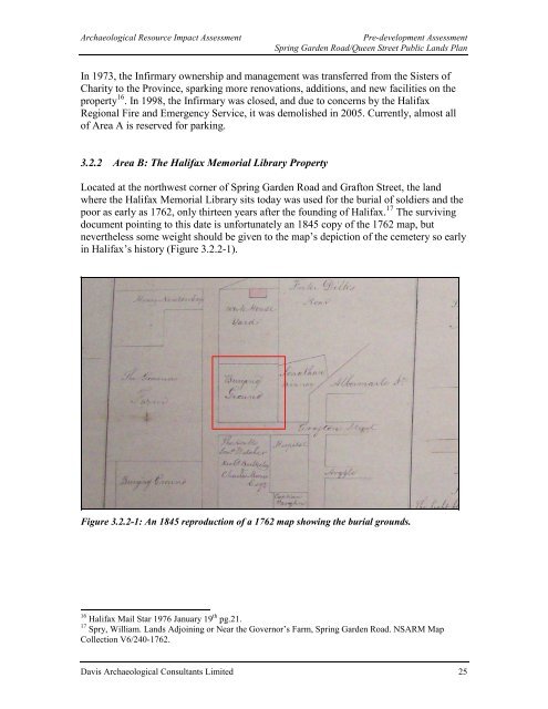
3.2.2 Area B: The <strong>Halifax</strong> Memorial Library Property<br />
Located at the northwest corner of Spring Garden Road and Grafton Street, the land<br />
where the <strong>Halifax</strong> Memorial Library sits today was used for the burial of soldiers and the<br />
poor as early as 1762, only thirteen years after the founding of <strong>Halifax</strong>. 17 The surviving<br />
document pointing to this date is unfortunately an 1845 copy of the 1762 map, but<br />
nevertheless some weight should be given to the map’s depiction of the cemetery so early<br />
in <strong>Halifax</strong>’s history (Figure 3.2.2-1).<br />
Figure 3.2.2-1: An 1845 reproduction of a 1762 map showing the burial grounds.<br />
16 <strong>Halifax</strong> Mail Star 1976 January 19 th pg.21.<br />
17 Spry, William. Lands Adjoining or Near the Governor’s Farm, Spring Garden Road. NSARM Map<br />
Collection V6/240-1762.<br />
Davis Archaeological Consultants Limited 25


