Part II - IPA SA
Part II - IPA SA
Part II - IPA SA

You also want an ePaper? Increase the reach of your titles
YUMPU automatically turns print PDFs into web optimized ePapers that Google loves.
REVISTA ROMÂN DE AUTOMATIC<br />
67<br />
Gases dispersion, noxious emissions,<br />
impact area prognosis, simulation module<br />
The main factors involved in the atmospheric<br />
dispersion are:<br />
1. Severe unstable atmospheric conditions<br />
lead to a quick mix and dispersion of the<br />
particles in the air, while stable atmospheric<br />
conditions prohibit that to happen<br />
2. Mechanical turbulence due to the wind,<br />
soils, forests and hills<br />
3. Existing temperature gradient till 30<br />
meters high in the atmosphere<br />
4. The most unfavourable condition for<br />
dispersion is the quiet atmosphere from silent<br />
nights and early mornings<br />
Another unfavourable situation for the<br />
dispersion is a not enough higher ceiling. The<br />
most favourable situation for a dispersion is a<br />
strong sun and wind breezes in the superior<br />
levels of the atmosphere. During the<br />
exploding gas recipients, the area affected is<br />
not limited, so you have to consider also the<br />
following factors:<br />
A. Direction of the gas (horizontal,<br />
vertical), speed and wind direction<br />
B. General weather conditions and field<br />
topography<br />
C. Speed, temperature and gas emission<br />
concentration<br />
The potential risks due to the stocking and<br />
transporting the chemical products are being<br />
analysed in 3 different stages:<br />
- identify the risk<br />
- analyse the impacts<br />
- analyse the causes of the risk and<br />
minimise them<br />
The dilution of a toxic cloud in unstable<br />
atmosphere conditions is much quicker and<br />
achieves a shorter distance than in stable<br />
conditions: from this we deduce risks in<br />
stable conditions (no wind and clouds are on<br />
a low level) The possible effects of pollution,<br />
chemical accident from power plants and the<br />
impact towards populated areas are being<br />
emphasized by a program packet that presents<br />
the evolution of the toxic cloud and the<br />
dispersion analysis through a map. Through<br />
the screen the noxious and gas emission is<br />
being presented also with the speed and wind<br />
direction and the stability class. The required<br />
data’s that allows a visualization of the<br />
medium concentration are being provided by<br />
packet programs that modulates the pollution<br />
emission processes for the gas, liquid or<br />
biphasic stages, evaporation, dispersion, heat<br />
radiation, explosions and fires. The medium<br />
concentrations for a long period and for an<br />
existing receiver are important as a distinct<br />
field; every checkpoint of the module<br />
network (concentric toward the pollution<br />
source) has two plane co-ordinates and an<br />
attached concentration class.<br />
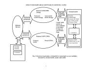
It was elaborated calculus programs, to<br />
evaluate, in emergency situations, the<br />
magnitude of impact area. They are built on<br />
the basis of usual mathematical models for<br />
plant noxious hold-up, release flow rate of the<br />
pollutant and atmospherically dispersion of<br />
toxic gas dispersion and use dimensional size<br />
of the plant (volumes, diameters, etc.) and<br />
automatic monitored data (technological<br />
parameters, pollutant concentration in air,<br />
meteorological parameters). Decision factors<br />
will receive calculus results (fig. 3). These<br />
programs are essential components of an<br />
information system for emergency plan.<br />
The distinctive value field of the<br />
concentration classes is assimilated to a data<br />
field type Soundings and it is overpass in a<br />
batch-mode through a digital map of the<br />
interest area, thus obtaining a geographical<br />
link in time between the pollution substance<br />
(dispersion, medium concentrations) and the<br />
environment. Time studying evolution of the<br />
environment concentrations, in a<br />
geographical context allows reaching at the<br />
results classified in:<br />
- geographical results. We obtain these<br />
results from direct information’s as:<br />
pollution cloud dimensions, affected area<br />
parameters- classes of concentrations,<br />
regions, districts that are affected<br />
- the impact towards medium, population in<br />
particular, by processing a data base that<br />
contains information’s about the attributes<br />
of the affected objects, presenting the<br />
number of inhabitants that are affected by<br />
lethal concentrations.