FEIS Summary - Knik Arm Bridge and Toll Authority
FEIS Summary - Knik Arm Bridge and Toll Authority
FEIS Summary - Knik Arm Bridge and Toll Authority

Create successful ePaper yourself
Turn your PDF publications into a flip-book with our unique Google optimized e-Paper software.
<strong>Knik</strong> <strong>Arm</strong> Crossing Final EIS<br />
<strong>Summary</strong><br />
regarding this alternative’s potential to<br />
adversely affect beluga whales.<br />
FHWA identified the 8,200-foot-long<br />
pier-supported bridge as the Preferred<br />
Alternative in the Draft EIS because, in<br />
addition to its constructibility (lower<br />
construction costs, shorter construction<br />
time), a shorter bridge will have fewer<br />
piers, resulting in less construction noise<br />
<strong>and</strong> shorter in-water construction time.<br />
Less noise <strong>and</strong> shorter construction time<br />
mean less potential to disrupt beluga<br />
whale behavior <strong>and</strong> movement patterns.<br />
As discussed above, this bridge<br />
alternative is not expected to affect tidal<br />
flows or naturally occurring<br />
sedimentation in the vicinity of the POA.<br />
Identification of Recommended<br />
Alternative<br />
FHWA identified the 8,200-foot-long<br />
<strong>Bridge</strong> Alternative as the Recommended<br />
Alternative for the reasons noted in the<br />
“Comparison of Impacts” section, above.<br />
Based on agency comments on the Draft<br />
EIS <strong>and</strong> results from additional<br />
hydrodynamic modeling, close agency<br />
coordination will continue during the<br />
design <strong>and</strong> permitting stages.<br />
Anchorage<br />
Description of Anchorage Alternatives<br />
The Draft EIS evaluated two Anchorage<br />
approach alternatives: Degan Alternative<br />
<strong>and</strong> Erickson Alternative. As Exhibits<br />
S-17 <strong>and</strong> S-18 depict, the logical termini<br />
for both alternatives is the intersection of<br />
the A-C Couplet with 3rd Avenue during<br />
Phase 1 (opening day) <strong>and</strong> the<br />
intersection of the Ingra-Gambell Couplet<br />
with 3rd Avenue during Phase 2. For<br />
either alternative, construction of Phase 2<br />
would occur as traffic volumes warrant.<br />
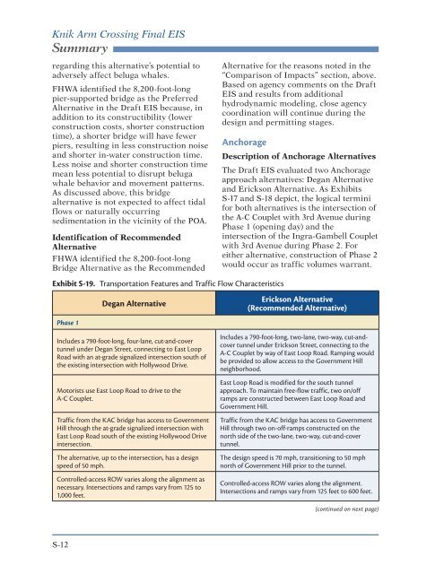
Exhibit S‐19. Transportation Features <strong>and</strong> Traffic Flow Characteristics<br />
Degan Alternative<br />
Erickson Alternative<br />
(Recommended Alternative)<br />
Phase 1<br />
Includes a 790-foot-long, four-lane, cut-<strong>and</strong>-cover<br />
tunnel under Degan Street, connecting to East Loop<br />
Road with an at-grade signalized intersection south of<br />
the existing intersection with Hollywood Drive.<br />
Motorists use East Loop Road to drive to the<br />
A-C Couplet.<br />
Traffic from the KAC bridge has access to Government<br />
Hill through the at-grade signalized intersection with<br />
East Loop Road south of the existing Hollywood Drive<br />
intersection.<br />
The alternative, up to the intersection, has a design<br />
speed of 50 mph.<br />
Controlled-access ROW varies along the alignment as<br />
necessary. Intersections <strong>and</strong> ramps vary from 125 to<br />
1,000 feet.<br />
Includes a 790-foot-long, two-lane, two-way, cut-<strong>and</strong>cover<br />
tunnel under Erickson Street, connecting to the<br />
A-C Couplet by way of East Loop Road. Ramping would<br />
be provided to allow access to the Government Hill<br />
neighborhood.<br />
East Loop Road is modified for the south tunnel<br />
approach. To maintain free-flow traffic, two on/off<br />
ramps are constructed between East Loop Road <strong>and</strong><br />
Government Hill.<br />
Traffic from the KAC bridge has access to Government<br />
Hill through two on-off-ramps constructed on the<br />
north side of the two-lane, two-way, cut-<strong>and</strong>-cover<br />
tunnel.<br />
The design speed is 70 mph, transitioning to 50 mph<br />
north of Government Hill prior to the tunnel.<br />
Controlled-access ROW varies along the alignment.<br />
Intersections <strong>and</strong> ramps vary from 125 feet to 600 feet.<br />
(continued on next page)<br />
S-12