FEIS Summary - Knik Arm Bridge and Toll Authority
FEIS Summary - Knik Arm Bridge and Toll Authority
FEIS Summary - Knik Arm Bridge and Toll Authority

Create successful ePaper yourself
Turn your PDF publications into a flip-book with our unique Google optimized e-Paper software.
<strong>Knik</strong> <strong>Arm</strong> Crossing Final EIS<br />
<strong>Summary</strong><br />
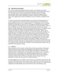
The preliminary design includes plans for<br />
potential future expansion (Phase 2) when<br />
traffic volumes would warrant its completion.<br />
In the Mat-Su, the project’s controlled-access<br />
right-of-way 1 would be large enough to exp<strong>and</strong><br />
to two lanes in each direction, including<br />
accommodations for a pathway.<br />
Proposed right-of-way (Phase: 1 <strong>and</strong> 2), typically 400 to 450 feet wide<br />
Future expansion (Phase 2) Proposed Mat-Su roadway (Phase 1)<br />
Future expansion (Phase 2)<br />
1<br />
a designation that allows intersecting roads or driveways at<br />
only limited points to promote safety <strong>and</strong> travel efficiency<br />
Future pathway<br />
Future two-way<br />
frontage road<br />
Future divided<br />
roadway expansion<br />
Future two-way<br />
frontage road<br />
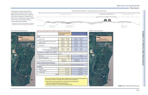
Point MacKenzie Road Alternative<br />
Sources: Imagery from SMB June 2004<br />
MSB GIS, HDR Inc.<br />
0 0.5 1 Mile<br />
Key Costs <strong>and</strong> Impacts for Mat-Su Approach Alternatives<br />
Costs<br />
Construction<br />
Design, engineering, <strong>and</strong> construction<br />
administration<br />
Contingency<br />
Total (by phase)<br />
(Note that Phase 2 would include<br />
future build-out of project.)<br />
Point MacKenzie Road<br />
Alternative<br />
Phase 1: $33.7M<br />
Phase 2: 31.2M<br />
Phase 1: 4.9M<br />
Phase 2: 4.5M<br />
Phase 1: 7.0M<br />
Phase 2: 11.3M<br />
Phase 1: 45.6M<br />
Phase 2: 47.0M<br />
Northern Access Alternative<br />
(Recommended Alternative)<br />
Phase 1: $34.2M<br />
Phase 2: 28.7M<br />
Phase 1: 5.0M<br />
Phase 2: 4.2M<br />
Phase 1: 7.2M<br />
Phase 2: 10.3M<br />
Phase 1: 46.4M<br />
Phase 2: 43.2M<br />
Controlled-Access Right-of-way (ROW): A designation that allows intersecting roads or driveways at only<br />
limited points to promote safety <strong>and</strong> travel efficiency.<br />
ROW costs $0.8M $0.6M<br />
Affected l<strong>and</strong> parcels 30 28<br />
ROW acquisitions/relocations<br />
Section 4(f) Recreational Properties<br />
Businesses: 0<br />
Residences: 0<br />
Businesses: 0<br />
Residences: 0<br />
Point MacKenzie Recreational Trailhead 0.55 acre of trailhead used 0 acres of trailhead used<br />
Wetl<strong>and</strong>s<br />
Forested 14.2 acres 9.7 acres<br />
Sedge <strong>and</strong> grass 17.3 acres 15.5 acres<br />
Scrub/shrub 5.9 acres 3.3 acres<br />
Total 37.4 acres 28.5 acres<br />
Northern Access Alternative<br />
Sources: Imagery from SMB June 2004<br />
MSB GIS, HDR Inc.<br />
0 0.5 1 Mile<br />
Exhibit S-15 Mat-Su Side Alternatives<br />
Because many impacts are relatively equal, FHWA prefers the Northern Access Alternative for<br />
its consistency with Mat-Su Borough <strong>and</strong> Port MacKenzie planning efforts.<br />
As part of the Recommended Alternative, the Northern Access Alternative:<br />
• will remove through-traffic from Port MacKenzie<br />
• will be more conducive to Port MacKenzie expansion plans<br />
Exhibit S-15. Mat-Su Side Alternatives<br />
S-32