FEIS Summary - Knik Arm Bridge and Toll Authority
FEIS Summary - Knik Arm Bridge and Toll Authority
FEIS Summary - Knik Arm Bridge and Toll Authority

Create successful ePaper yourself
Turn your PDF publications into a flip-book with our unique Google optimized e-Paper software.
<strong>Knik</strong> <strong>Arm</strong> Crossing Final EIS<br />
<strong>Summary</strong><br />
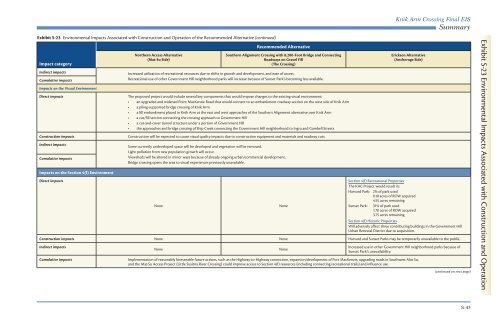
Exhibit S-23 Environmental Impacts Associated with Construction <strong>and</strong> Operation of the Recommended Alternative (continued)<br />
Impact category<br />
Indirect impacts<br />
Cumulative impacts<br />
Impacts on the Visual Environment<br />
Direct impacts<br />
Construction impacts<br />
Indirect impacts<br />
Cumulative impacts<br />
Impacts on the Section 4(f) Environment<br />
Direct impacts<br />
Northern Access Alternative<br />
(Mat-Su Side)<br />
Recommended Alternative<br />
Southern Alignment Crossing with 8,200-Foot <strong>Bridge</strong> <strong>and</strong> Connecting<br />
Roadways on Gravel Fill<br />
(The Crossing)<br />
Increased utilization of recreational resources due to shifts in growth <strong>and</strong> development, <strong>and</strong> ease of access.<br />
Recreational use of other Government Hill neighborhood parks will increase because of Sunset Park’s becoming less available.<br />
The proposed project would include several key components that would impose changes to the existing visual environment:<br />
• an upgraded <strong>and</strong> widened Point MacKenzie Road that would connect to an embankment roadway section on the west side of <strong>Knik</strong> <strong>Arm</strong><br />
• a piling-supported bridge crossing of <strong>Knik</strong> <strong>Arm</strong><br />
• a fill embankment placed in <strong>Knik</strong> <strong>Arm</strong> at the east <strong>and</strong> west approaches of the Southern Alignment alternative over <strong>Knik</strong> <strong>Arm</strong><br />
• a cut/fill section connecting the crossing approach to Government Hill<br />
• a cut-<strong>and</strong>-cover tunnel structure under a portion of Government Hill<br />
• the approaches <strong>and</strong> bridge crossing of Ship Creek connecting the Government Hill neighborhood to Ingra <strong>and</strong> Gambell Streets<br />
Construction will be expected to cause visual quality impacts due to construction equipment <strong>and</strong> materials <strong>and</strong> roadway cuts.<br />
Some currently undeveloped space will be developed <strong>and</strong> vegetation will be removed.<br />
Light pollution from new population growth will occur.<br />
Viewsheds will be altered in minor ways because of already ongoing urban/commercial development.<br />
<strong>Bridge</strong> crossing opens the area to visual experiences previously unavailable.<br />
None<br />
None<br />
Erickson Alternative<br />
(Anchorage Side)<br />
Section 4(f) Recreational Properties<br />
The KAC Project would result in:<br />
Harvard Park: 2% of park used<br />
0.10 acres of ROW acquired<br />
4.55 acres remaining<br />
Sunset Park: 31% of park used<br />
1.70 acres of ROW acquired<br />
3.75 acres remaining<br />
Section 4(f) Historic Properties<br />
Will adversely affect three contributing buildings in the Government Hill<br />
Urban Renewal District due to acquisition.<br />
Construction impacts None None Harvard <strong>and</strong> Sunset Parks may be temporarily unavailable to the public.<br />
Indirect impacts<br />
Cumulative impacts<br />
None<br />
None<br />
Increased use in other Government Hill neighborhood parks because of<br />
Sunset Park’s unavailability.<br />
Implementation of reasonably foreseeable future actions, such as the Highway-to-Highway connection, expansion/development of Port MacKenzie, upgrading roads in Southwest Mat Su,<br />
<strong>and</strong> the Mat-Su Access Project (Little Susitna River Crossing) could improve access to Section 4(f) resources (including connecting recreational trails) <strong>and</strong> influence use.<br />
(continued on next page)<br />
Exhibit S-23 Environmental Impacts Associated with Construction <strong>and</strong> Operation<br />
S-43