FEIS Summary - Knik Arm Bridge and Toll Authority
FEIS Summary - Knik Arm Bridge and Toll Authority
FEIS Summary - Knik Arm Bridge and Toll Authority

You also want an ePaper? Increase the reach of your titles
YUMPU automatically turns print PDFs into web optimized ePapers that Google loves.
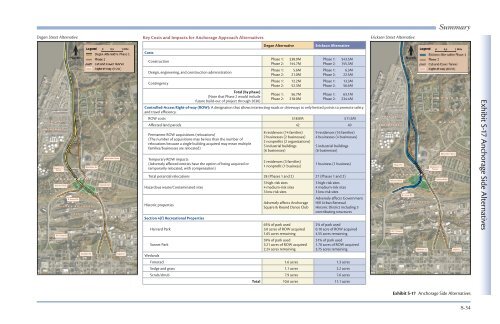
<strong>Summary</strong><br />
Degan Street Alternative<br />
Key Costs <strong>and</strong> Impacts for Anchorage Approach Alternatives<br />
Erickson Street Alternative<br />
North<br />
0 0.5 1 Mile<br />
Costs<br />
Construction<br />
Design, engineering, <strong>and</strong> construction administration<br />
Contingency<br />
Total (by phase)<br />
(Note that Phase 2 would include<br />
future build-out of project through 2030)<br />
Degan Alternative<br />
Phase 1: $38.9M<br />
Phase 2: 144.7M<br />
Phase 1: 5.6M<br />
Phase 2: 21.0M<br />
Phase 1: 12.2M<br />
Phase 2: 52.3M<br />
Phase 1: 56.7M<br />
Phase 2: 218.0M<br />
Erickson Alternative<br />
Phase 1: $43.5M<br />
Phase 2: 155.3M<br />
Phase 1: 6.3M<br />
Phase 2: 22.5M<br />
Phase 1: 13.3M<br />
Phase 2: 56.6M<br />
Phase 1: 63.1M<br />
Phase 2: 234.4M<br />
Controlled-Access Right-of-way (ROW): A designation that allows intersecting roads or driveways at only limited points to promote safety<br />
<strong>and</strong> travel efficiency.<br />
ROW costs $18.0M $11.5M<br />
Affected l<strong>and</strong> parcels 42 40<br />
Permanent ROW acquisitions (relocations)<br />
(The number of acquisitions may be less than the number of<br />
relocations because a single building acquired may mean multiple<br />
families/businesses are relocated)<br />
Temporary ROW impacts<br />
(Adversely affected entities have the option of being acquired or<br />
temporarily relocated, with compensation)<br />
8 residences (14 families)<br />
2 businesses (2 businesses)<br />
2 nonprofits (2 organizations)<br />
5 industrial buildings<br />
(6 businesses)<br />
2 residences (3 families)<br />
1 nonprofit (1 business)<br />
9 residences (16 families)<br />
4 businesses (4 businesses)<br />
5 industrial buildings<br />
(6 businesses)<br />
1 business (1 business)<br />
Total potential relocations 28 (Phases 1 <strong>and</strong> 2) 27 (Phases 1 <strong>and</strong> 2)<br />
Hazardous waste/Contaminated sites<br />
Historic properties<br />
Section 4(f) Recreational Properties<br />
Harvard Park<br />
Sunset Park<br />
Wetl<strong>and</strong>s<br />
3 high-risk sites<br />
4 medium-risk sites<br />
3 low-risk sites<br />
Adversely affects Anchorage<br />
Square & Round Dance Club<br />
65% of park used<br />
3.0 acres of ROW acquired<br />
1.65 acres remaining<br />
59% of park used<br />
3.21 acres of ROW acquired<br />
2.24 acres remaining<br />
3 high-risk sites<br />
4 medium-risk sites<br />
3 low-risk sites<br />
Adversely affects Government<br />
Hill Urban Renewal<br />
Historic District including 3<br />
contributing structures<br />
2% of park used<br />
0.10 acre of ROW acquired<br />
4.55 acres remaining<br />
31% of park used<br />
1.70 acres of ROW acquired<br />
3.75 acres remaining<br />
Forested 1.6 acres 1.3 acres<br />
Sedge <strong>and</strong> grass 1.1 acres 2.2 acres<br />
Scrub/shrub 7.9 acres 7.6 acres<br />
Total 10.6 acres 11.1 acres<br />
North<br />
0 0.5 1 Mile<br />
Exhibit S-17 Anchorage Side Alternatives<br />
Exhibit S-17 Anchorage Side Alternatives<br />
S-34