FEIS Summary - Knik Arm Bridge and Toll Authority
FEIS Summary - Knik Arm Bridge and Toll Authority
FEIS Summary - Knik Arm Bridge and Toll Authority

You also want an ePaper? Increase the reach of your titles
YUMPU automatically turns print PDFs into web optimized ePapers that Google loves.
<strong>Knik</strong> <strong>Arm</strong> Crossing Final EIS<br />
<strong>Summary</strong><br />
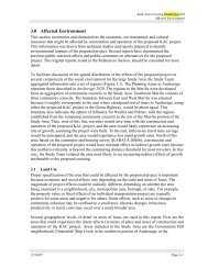
Exhibit S-23 Environmental Impacts Associated with Construction <strong>and</strong> Operation of the Recommended Alternative (continued)<br />
Impact category<br />
Construction impacts<br />
Indirect impacts<br />
Cumulative impacts<br />
Impacts on Floodplains<br />
Direct impacts<br />
Construction impacts<br />
Indirect impacts<br />
Cumulative impacts<br />
Impacts on Wild <strong>and</strong> Scenic Rivers<br />
Direct impacts<br />
Construction impacts<br />
Indirect impacts<br />
Cumulative impacts<br />
Impacts on Coastal Barriers<br />
Direct impacts<br />
Construction impacts<br />
Indirect impacts<br />
Cumulative impacts<br />
Northern Access Alternative<br />
(Mat-Su Side)<br />
Four acres of forested, scrub/shrub, <strong>and</strong> sedge or grass wetl<strong>and</strong>s will be affected.<br />
Soil will be disturbed, deposition of sediments <strong>and</strong> other pollutants will increase,<br />
<strong>and</strong> vegetation will be permanently altered by such disturbance.<br />
Wildlife use of the areas of vegetation disturbance will be temporarily adversely<br />
affected.<br />
Recommended Alternative<br />
Southern Alignment Crossing with 8,200-Foot <strong>Bridge</strong> <strong>and</strong> Connecting<br />
Roadways on Gravel Fill<br />
(The Crossing)<br />
Additional wetl<strong>and</strong> area eliminated by 2030 due to development in the Mat-Su, relative to loss under the No-Action Alternative:<br />
Forested:<br />
70 acres<br />
Sedge <strong>and</strong> grass: 260 acres<br />
Scrub/shrub:<br />
120 acres<br />
Total:<br />
450 acres<br />
None<br />
Erickson Alternative<br />
(Anchorage Side)<br />
Two acres of forested, scrub/shrub, <strong>and</strong> sedge or grass wetl<strong>and</strong>s will be affected.<br />
Soil will be disturbed, deposition of sediments <strong>and</strong> other pollutants will increase,<br />
<strong>and</strong> vegetation will be permanently altered by such disturbance.<br />
Wildlife use of the areas of vegetation disturbance will be temporarily displaced.<br />
The total cumulative reduction of 819.6 acres includes 808.5 acres (0.9% reduction) in total Mat-Su Project Area wetl<strong>and</strong>s which would not alter Mat-Su regional wetl<strong>and</strong> functions <strong>and</strong><br />
values.<br />
None<br />
Stream crossings by roads caused by indirect growth will have the potential<br />
to adversely affect floodplains unless unrestricted flow will be maintained.<br />
Development pressure in the Mat-Su Borough would be more aggressive,<br />
increasing the cumulative impact potential of residential <strong>and</strong> commercial<br />
development on marginal floodplain areas.<br />
There are no designated Wild <strong>and</strong> Scenic Rivers located within the Project Area.<br />
A 0.3 inch decrease in the extreme high-tide level north of the bridge could<br />
occur during extreme high-tide events.<br />
None<br />
As identified under the Coastal Barriers Resource Act, there are no coastal barriers in the Project Area.<br />
N/A<br />
None<br />
Development pressure in the Anchorage Bowl would be less aggressive,<br />
alleviating the cumulative impact potential of residential <strong>and</strong> commercial<br />
development on marginal floodplain areas.<br />
(continued on next page)<br />
Exhibit S-23 Environmental Impacts Associated with Construction <strong>and</strong> Operation<br />
S-45