FEIS Summary - Knik Arm Bridge and Toll Authority
FEIS Summary - Knik Arm Bridge and Toll Authority
FEIS Summary - Knik Arm Bridge and Toll Authority

Create successful ePaper yourself
Turn your PDF publications into a flip-book with our unique Google optimized e-Paper software.
<strong>Knik</strong> <strong>Arm</strong> Crossing Final EIS<br />
<strong>Summary</strong><br />
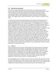
Exhibit S‐3. Build alternatives evaluated in the Draft EIS begin at the intersection of Point MacKenzie Road<br />
<strong>and</strong> Burma Road <strong>and</strong> end in Downtown Anchorage. Components common to all alternatives are noted by<br />
the labeled call-out boxes. Variations among alternatives are noted by the variously colored lines.<br />
volumes grow. The EIS fully discloses<br />
the environmental impacts anticipated<br />
to result during the 20-year design life of<br />
the project (through 2030) <strong>and</strong> describes<br />
the anticipated timing of project<br />
elements in two phases. These phases<br />
include an initial minimum two-lane<br />
Crossing (8,200-foot bridge structure<br />
<strong>and</strong> connecting roadway sections on<br />
gravel fill) <strong>and</strong> a connection to the A-C<br />
Couplet in Phase 1 (anticipated in 2010).<br />
By the design year 2030, traffic modeling<br />
indicates the need to exp<strong>and</strong> the bridge<br />
Crossing <strong>and</strong> Mat-Su <strong>and</strong> Anchorage<br />
Approach Alternatives to four lanes <strong>and</strong><br />
to connect to the Ingra-Gambell Couplet<br />
facility in Phase 2.<br />
Phase 1 construction will include<br />
improvements to existing roadways <strong>and</strong><br />
development of the Mat-Su Approach<br />
Alternative; construction of the Crossing<br />
(8,200-foot bridge structure <strong>and</strong><br />
S-7