intermodal solutions for transalpine freight traffic - Alpine Space ...
intermodal solutions for transalpine freight traffic - Alpine Space ...
intermodal solutions for transalpine freight traffic - Alpine Space ...

You also want an ePaper? Increase the reach of your titles
YUMPU automatically turns print PDFs into web optimized ePapers that Google loves.
supply model<br />
The supply model is a mathematical description<br />
of the main elements of the actual system<br />
and their interrelations. It is based on a theory<br />
of the graphs, on the functions of costs/flows<br />
and on the per<strong>for</strong>mances (e.g. level of service)<br />
of the arcs in the network.<br />
The following paragraph describes the<br />
carachteritical sequences when building up the<br />
supply model.<br />
The first phase consisted in the delimitation<br />
of the study area (the geographic area which<br />
encompasses the transport system to be analyzed).<br />
In more detailed words the area of interest<br />
functionally affected by the by the majority<br />
of the effects of the planned interventions Thus,<br />
the area outside of the zone of the analysis,<br />
is the exterior environment. It is excusively affected<br />
by the interconnections with the project<br />
system.<br />
In the second phase the study area has been<br />
framed in homogeneous <strong>traffic</strong> areas from<br />
the point of view of the settlement characteristics<br />
and of the transport offer, at a level which<br />
is compatible with the thoroughness of the data<br />
provided by WP4 and WP5. A point have been<br />
associated to each area (centroid node) where<br />
the origin and destination matrices are concentrated<br />
<strong>for</strong> the movements regarding the area of<br />
interest.<br />
The model <strong>for</strong>esee the subdivision of the<br />
area of study in 1043 homogenous areas<br />
(centroid deriving from the Project AlpenCors)<br />
where the origins and destinations of the transfers<br />
are likely to be located. Fig.<br />
In this specific analysis, the zoning was implemented<br />
by the subdivion with more narrow<br />
sub-areas referred to zones which are more<br />
strategical in view of the functionality of the <strong>Alpine</strong><br />
network, in particular with respect to those<br />
which are considered within the context of the<br />
Pilot Projects.<br />
The extraction of the graphs consented<br />
the identification of the space-time positions<br />
(nodes) and of the connections (arcs), which<br />
were considered relevant in view of the representation<br />
of the network.<br />
The infrastructures to be included in the<br />
model have there<strong>for</strong>e been identified, included<br />
the (fictitious) arcs which link the centroid and<br />
the network as well as the characteristic of the<br />
elements of the graph.<br />
In particular, the reference network was implemented<br />
with the following parameters:<br />
• basic characteristics (topological in<strong>for</strong>mation),<br />
• infrastructures (length, width, number of<br />
lanes and of rails),<br />
• quality of the service (commitment/capacity<br />
relationship and basic average speed)<br />
• cost <strong>for</strong> the user (motorway toll differentiated<br />
per subject managing in Euro/km, where<br />
this is present; cost of the tickets <strong>for</strong> railway<br />
users etc).<br />
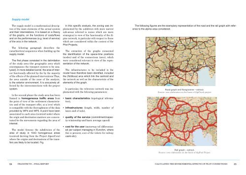
The following figures are the exemplary representation of the road and the rail graph with reference<br />
to the alpine area considered.<br />
Road graph and flowgramme – extract.<br />
Source: own elaboration on the basis of AlpCheck project<br />
Rail graph – extract.<br />
Source: own elaboration on the basis of AlpFrail Project<br />
84 transitects – final report<br />
CalCulating the environmental effeCts of pilot ConneCtions<br />
85