

the wisconsin tornado outbreak of 23 june 2004 - National Weather ...
the wisconsin tornado outbreak of 23 june 2004 - National Weather ...
the wisconsin tornado outbreak of 23 june 2004 - National Weather ...

You also want an ePaper? Increase the reach of your titles
YUMPU automatically turns print PDFs into web optimized ePapers that Google loves.
Gehring<br />
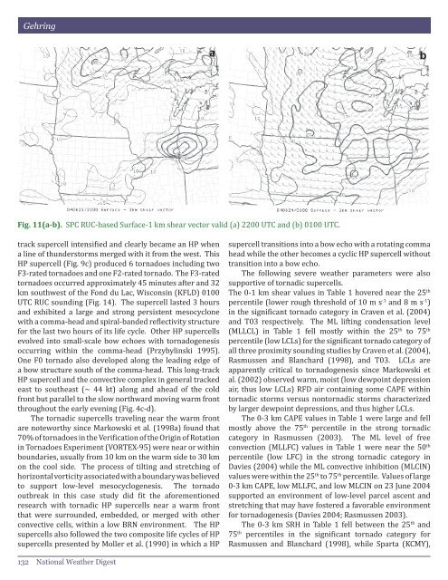
Fig. 11(a-b). SPC RUC-based Surface-1 km shear vector valid (a) 2200 UTC and (b) 0100 UTC.<br />
track supercell intensified and clearly became an HP when<br />
a line <strong>of</strong> thunderstorms merged with it from <strong>the</strong> west. This<br />
HP supercell (Fig. 9c) produced 6 <strong>tornado</strong>es including two<br />
F3-rated <strong>tornado</strong>es and one F2-rated <strong>tornado</strong>. The F3-rated<br />
<strong>tornado</strong>es occurred approximately 45 minutes after and 32<br />
km southwest <strong>of</strong> <strong>the</strong> Fond du Lac, Wisconsin (KFLD) 0100<br />
UTC RUC sounding (Fig. 14). The supercell lasted 3 hours<br />
and exhibited a large and strong persistent mesocyclone<br />
with a comma-head and spiral-banded reflectivity structure<br />
for <strong>the</strong> last two hours <strong>of</strong> its life cycle. O<strong>the</strong>r HP supercells<br />
evolved into small-scale bow echoes with <strong>tornado</strong>genesis<br />
occurring within <strong>the</strong> comma-head (Przybylinski 1995).<br />
One F0 <strong>tornado</strong> also developed along <strong>the</strong> leading edge <strong>of</strong><br />
a bow structure south <strong>of</strong> <strong>the</strong> comma-head. This long-track<br />
HP supercell and <strong>the</strong> convective complex in general tracked<br />
east to sou<strong>the</strong>ast (~ 44 kt) along and ahead <strong>of</strong> <strong>the</strong> cold<br />
front but parallel to <strong>the</strong> slow northward moving warm front<br />
throughout <strong>the</strong> early evening (Fig. 4c-d).<br />
The tornadic supercells traveling near <strong>the</strong> warm front<br />
are noteworthy since Markowski et al. (1998a) found that<br />
70% <strong>of</strong> <strong>tornado</strong>es in <strong>the</strong> Verification <strong>of</strong> <strong>the</strong> Origin <strong>of</strong> Rotation<br />
in Tornadoes Experiment (VORTEX-95) were near or within<br />
boundaries, usually from 10 km on <strong>the</strong> warm side to 30 km<br />
on <strong>the</strong> cool side. The process <strong>of</strong> tilting and stretching <strong>of</strong><br />
horizontal vorticity associated with a boundary was believed<br />
to support low-level mesocyclogenesis. The <strong>tornado</strong><br />
<strong>outbreak</strong> in this case study did fit <strong>the</strong> aforementioned<br />
research with tornadic HP supercells near a warm front<br />
that were surrounded, embedded, or merged with o<strong>the</strong>r<br />
convective cells, within a low BRN environment. The HP<br />
supercells also followed <strong>the</strong> two composite life cycles <strong>of</strong> HP<br />
supercells presented by Moller et al. (1990) in which a HP<br />
supercell transitions into a bow echo with a rotating comma<br />
head while <strong>the</strong> o<strong>the</strong>r becomes a cyclic HP supercell without<br />
transition into a bow echo.<br />
The following severe wea<strong>the</strong>r parameters were also<br />
supportive <strong>of</strong> tornadic supercells.<br />
The 0-1 km shear values in Table 1 hovered near <strong>the</strong> 25 th<br />
percentile (lower rough threshold <strong>of</strong> 10 m s -1 and 8 m s -1 )<br />
in <strong>the</strong> significant <strong>tornado</strong> category in Craven et al. (<strong>2004</strong>)<br />
and T03 respectively. The ML lifting condensation level<br />
(MLLCL) in Table 1 fell mostly within <strong>the</strong> 25 th to 75 th<br />
percentile (low LCLs) for <strong>the</strong> significant <strong>tornado</strong> category <strong>of</strong><br />
all three proximity sounding studies by Craven et al. (<strong>2004</strong>),<br />
Rasmussen and Blanchard (1998), and T03. LCLs are<br />
apparently critical to <strong>tornado</strong>genesis since Markowski et<br />
al. (2002) observed warm, moist (low dewpoint depression<br />
air, thus low LCLs) RFD air containing some CAPE within<br />
tornadic storms versus nontornadic storms characterized<br />
by larger dewpoint depressions, and thus higher LCLs.<br />
The 0-3 km CAPE values in Table 1 were large and fell<br />
mostly above <strong>the</strong> 75 th percentile in <strong>the</strong> strong tornadic<br />
category in Rasmussen (2003). The ML level <strong>of</strong> free<br />
convection (MLLFC) values in Table 1 were near <strong>the</strong> 50 th<br />
percentile (low LFC) in <strong>the</strong> strong tornadic category in<br />
Davies (<strong>2004</strong>) while <strong>the</strong> ML convective inhibition (MLCIN)<br />
values were within <strong>the</strong> 25 th to 75 th percentile. Values <strong>of</strong> large<br />
0-3 km CAPE, low MLLFC, and low MLCIN on <strong>23</strong> June <strong>2004</strong><br />
supported an environment <strong>of</strong> low-level parcel ascent and<br />
stretching that may have fostered a favorable environment<br />
for <strong>tornado</strong>genesis (Davies <strong>2004</strong>; Rasmussen 2003).<br />
The 0-3 km SRH in Table 1 fell between <strong>the</strong> 25 th and<br />
75 th percentiles in <strong>the</strong> significant <strong>tornado</strong> category for<br />
Rasmussen and Blanchard (1998), while Sparta (KCMY),<br />
132 <strong>National</strong> Wea<strong>the</strong>r Digest


