

the wisconsin tornado outbreak of 23 june 2004 - National Weather ...
the wisconsin tornado outbreak of 23 june 2004 - National Weather ...
the wisconsin tornado outbreak of 23 june 2004 - National Weather ...

You also want an ePaper? Increase the reach of your titles
YUMPU automatically turns print PDFs into web optimized ePapers that Google loves.
Gehring<br />
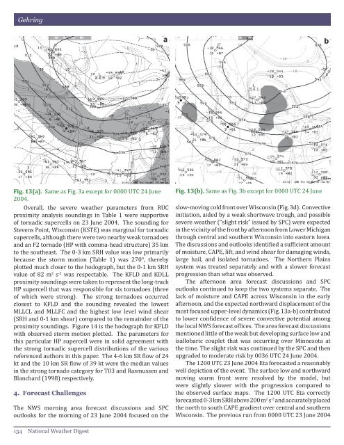
Fig. 13(a). Same as Fig. 3a except for 0000 UTC 24 June<br />
<strong>2004</strong>.<br />
Overall, <strong>the</strong> severe wea<strong>the</strong>r parameters from RUC<br />
proximity analysis soundings in Table 1 were supportive<br />
<strong>of</strong> tornadic supercells on <strong>23</strong> June <strong>2004</strong>. The sounding for<br />
Stevens Point, Wisconsin (KSTE) was marginal for tornadic<br />
supercells, although <strong>the</strong>re were two nearby weak <strong>tornado</strong>es<br />
and an F2 <strong>tornado</strong> (HP with comma-head structure) 35 km<br />
to <strong>the</strong> sou<strong>the</strong>ast. The 0-3 km SRH value was low primarily<br />
because <strong>the</strong> storm motion (Table 1) was 270°, <strong>the</strong>reby<br />
plotted much closer to <strong>the</strong> hodograph, but <strong>the</strong> 0-1 km SRH<br />
value <strong>of</strong> 82 m 2 s -2 was respectable. The KFLD and KDLL<br />
proximity soundings were taken to represent <strong>the</strong> long-track<br />
HP supercell that was responsible for six <strong>tornado</strong>es (three<br />
<strong>of</strong> which were strong). The strong <strong>tornado</strong>es occurred<br />
closest to KFLD and <strong>the</strong> sounding revealed <strong>the</strong> lowest<br />
MLLCL and MLLFC and <strong>the</strong> highest low level wind shear<br />
(SRH and 0-1 km shear) compared to <strong>the</strong> remainder <strong>of</strong> <strong>the</strong><br />
proximity soundings. Figure 14 is <strong>the</strong> hodograph for KFLD<br />
with observed storm motion plotted. The parameters for<br />
this particular HP supercell were in solid agreement with<br />
<strong>the</strong> strong tornadic supercell distributions <strong>of</strong> <strong>the</strong> various<br />
referenced authors in this paper. The 4-6 km SR flow <strong>of</strong> 24<br />
kt and <strong>the</strong> 10 km SR flow <strong>of</strong> 39 kt were <strong>the</strong> median values<br />
in <strong>the</strong> strong <strong>tornado</strong> category for T03 and Rasmussen and<br />
Blanchard (1998) respectively.<br />
4. Forecast Challenges<br />
The NWS morning area forecast discussions and SPC<br />
outlooks for <strong>the</strong> morning <strong>of</strong> <strong>23</strong> June <strong>2004</strong> focused on <strong>the</strong><br />
Fig. 13(b). Same as Fig. 3b except for 0000 UTC 24 June<br />
slow-moving cold front over Wisconsin (Fig. 3d). Convective<br />
initiation, aided by a weak shortwave trough, and possible<br />
severe wea<strong>the</strong>r (“slight risk” issued by SPC) were expected<br />
in <strong>the</strong> vicinity <strong>of</strong> <strong>the</strong> front by afternoon from Lower Michigan<br />
through central and sou<strong>the</strong>rn Wisconsin into eastern Iowa.<br />
The discussions and outlooks identified a sufficient amount<br />
<strong>of</strong> moisture, CAPE, lift, and wind shear for damaging winds,<br />
large hail, and isolated <strong>tornado</strong>es. The Nor<strong>the</strong>rn Plains<br />
system was treated separately and with a slower forecast<br />
progression than what was observed.<br />
The afternoon area forecast discussions and SPC<br />
outlooks continued to keep <strong>the</strong> two systems separate. The<br />
lack <strong>of</strong> moisture and CAPE across Wisconsin in <strong>the</strong> early<br />
afternoon, and <strong>the</strong> expected northward displacement <strong>of</strong> <strong>the</strong><br />
most focused upper-level dynamics (Fig. 13a-b) contributed<br />
to lower confidence <strong>of</strong> severe convective potential among<br />
<strong>the</strong> local NWS forecast <strong>of</strong>fices. The area forecast discussions<br />
mentioned little <strong>of</strong> <strong>the</strong> weak but developing surface low and<br />
isallobaric couplet that was occurring over Minnesota at<br />
<strong>the</strong> time. The slight risk was continued by <strong>the</strong> SPC and <strong>the</strong>n<br />
upgraded to moderate risk by 0036 UTC 24 June <strong>2004</strong>.<br />
The 1200 UTC <strong>23</strong> June <strong>2004</strong> Eta forecasted a reasonably<br />
well depiction <strong>of</strong> <strong>the</strong> event. The surface low and northward<br />
moving warm front were resolved by <strong>the</strong> model, but<br />
were slightly slower with <strong>the</strong> progression compared to<br />
<strong>the</strong> observed surface maps. The 1200 UTC Eta correctly<br />
forecasted 0-3 km SRH above 200 m 2 s -2 and accurately placed<br />
<strong>the</strong> north to south CAPE gradient over central and sou<strong>the</strong>rn<br />
Wisconsin. The previous run from 0000 UTC <strong>23</strong> June <strong>2004</strong><br />
134 <strong>National</strong> Wea<strong>the</strong>r Digest


