

the wisconsin tornado outbreak of 23 june 2004 - National Weather ...
the wisconsin tornado outbreak of 23 june 2004 - National Weather ...
the wisconsin tornado outbreak of 23 june 2004 - National Weather ...

Create successful ePaper yourself
Turn your PDF publications into a flip-book with our unique Google optimized e-Paper software.
Wisconsin Tornado Outbreak<br />
Eta was far<strong>the</strong>r north than <strong>the</strong> 1200 UTC run<br />
and positioned <strong>the</strong> morning cold front to <strong>the</strong><br />
east and south by late afternoon and evening.<br />
With no indication <strong>of</strong> <strong>the</strong> cold front possibly<br />
reversing and moving to <strong>the</strong> north as a warm<br />
front, <strong>the</strong> warm-air advection and 0-3 km SRH<br />
were consequently weaker. This case clearly<br />
was not “synoptically evident” (Doswell et<br />
al. 1993) on <strong>the</strong> Eta or <strong>the</strong> current analyses<br />
throughout <strong>the</strong> day due to <strong>the</strong> weak surface<br />
low, strong upper-level dynamics (Fig. 13a-b)<br />
north <strong>of</strong> <strong>the</strong> <strong>outbreak</strong> area and marginal<br />
CAPE over central Wisconsin. In addition, <strong>the</strong><br />
incorrect depiction <strong>of</strong> <strong>the</strong> event by <strong>the</strong> 0000<br />
UTC <strong>23</strong> June <strong>2004</strong> Eta model led to difficulty in<br />
determining how significant and widespread<br />
<strong>the</strong> severe wea<strong>the</strong>r would be.<br />
5. Summary and Conclusions<br />
On <strong>23</strong> June <strong>2004</strong>, Wisconsin’s fifth largest<br />
<strong>tornado</strong> <strong>outbreak</strong> occurred during <strong>the</strong> late<br />
afternoon and early evening hours. The<br />
parent deep moist convection was comprised<br />
<strong>of</strong> complex storm structures, bow echoes, and<br />
HP supercells. The event was characterized by<br />
a fast propagating isallobaric couplet and surface low with a<br />
100 kt 300-mb jet streak, and a pre-existing front that lifted<br />
northward as a warm front. Low-level tropospheric warmair<br />
advection, positive <strong>the</strong>ta-e advection, frontogenesis, and<br />
convergence along <strong>the</strong> fronts and surface troughs appeared<br />
to be <strong>the</strong> catalyst for synoptic scale and mesoscale lift. In<br />
addition, an increase in low-level wind shear late in <strong>the</strong><br />
day was a key ingredient in <strong>the</strong> development <strong>of</strong> tornadic<br />
supercells. The RUC proximity soundings were characterized<br />
by low BRN, low MLLCL, low MLLFC, low MLCIN, high 0-3<br />
km CAPE, high SRH, and high 0-1 km shear. The values <strong>of</strong><br />
<strong>the</strong>se parameters, were favorable for tornadic supercells by<br />
late afternoon and evening.<br />
This study suggests factors that can assist forecasters<br />
in anticipating high impact severe wea<strong>the</strong>r events when<br />
<strong>the</strong> numerical model predictions suggest o<strong>the</strong>rwise. These<br />
factors include a severe wea<strong>the</strong>r conceptual knowledge<br />
base, a diligent “wea<strong>the</strong>r watch”, and <strong>the</strong> utilization <strong>of</strong><br />
progressive tools (e.g., mesoscale models) that add value<br />
beyond well established forecast practices.<br />
Conceptual thinking based upon empirical forecast<br />
experience, informal case studies, and findings from<br />
published research provides <strong>the</strong> foundation from which<br />
forecasters can <strong>the</strong>n employ a diligent “wea<strong>the</strong>r watch” in a<br />
skilled and efficient manner. Knowing what to look for and<br />
<strong>the</strong> implications <strong>of</strong> what is found on all scales (i.e., synoptic,<br />
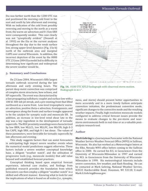
Fig. 14. 0100 UTC KFLD hodograph with observed storm motion.<br />
Hodograph in m s -1 .<br />
meso, and storm) should present better opportunities to<br />
more accurately and in a more timely fashion anticipate<br />
convection initiation, <strong>the</strong> predominant convective mode,<br />
significant changes to <strong>the</strong> convective mode and <strong>the</strong> resulting<br />
wea<strong>the</strong>r impacts. Finally, high resolution mesoscale models<br />
configured to address critical forecast issues provide <strong>the</strong><br />
means to evaluate changes to <strong>the</strong> pre-storm and nearstorm<br />
environments both in real-time or as a valuable postanalysis<br />
research tool.<br />
Author<br />
Mark Gehring is a Journeyman Forecaster with <strong>the</strong> <strong>National</strong><br />
Wea<strong>the</strong>r Service Wea<strong>the</strong>r Forecast Office (WFO) in Sullivan,<br />
Wisconsin. He also has worked as a Meteorologist Intern at<br />
<strong>the</strong> Elko, Nevada WFO <strong>of</strong>fice before coming to <strong>the</strong> Sullivan<br />
<strong>of</strong>fice in 2000. He earned his B.S. in Geosciences from <strong>the</strong><br />
University <strong>of</strong> Wisconsin-Milwaukee in 1997 and earned<br />
his M.S. in Geosciences from <strong>the</strong> University <strong>of</strong> Wisconsin-<br />
Milwaukee in 1999. His meteorological interests include<br />
severe convection, fire wea<strong>the</strong>r, and flash flooding. He can<br />
be contacted at Mark Gehring, <strong>National</strong> Wea<strong>the</strong>r Service,<br />
N3533 Hardscrabble Road, Dousman, WI 53118; E-mail:<br />
Mark.G.Gehring@noaa.gov.<br />
Volume 31 Number 2 ~ December 2007 135


