

the wisconsin tornado outbreak of 23 june 2004 - National Weather ...
the wisconsin tornado outbreak of 23 june 2004 - National Weather ...
the wisconsin tornado outbreak of 23 june 2004 - National Weather ...

You also want an ePaper? Increase the reach of your titles
YUMPU automatically turns print PDFs into web optimized ePapers that Google loves.
Wisconsin Tornado Outbreak<br />
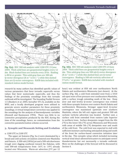
Fig. 3(a). RUC 300 mb analysis valid 1200 UTC <strong>23</strong> June<br />
<strong>2004</strong>. Thick solid lines are geopotential heights every 12<br />
dm. Black dashed lines are isotachs every 20 kt. Shading<br />
is 80 kt or greater. Thin solid gray lines are 300 mb<br />
Q-vector divergence (K m -2 1e16 s -1 ) while thin dashed<br />
lines are Q-vector convergence. RAOB data included with<br />
standard station model format.<br />
research by many authors has identified specific values <strong>of</strong><br />
various parameters that favor tornadic supercells versus<br />
values that favor nontornadic supercells, and thus <strong>the</strong><br />
findings <strong>of</strong> <strong>the</strong> proximity soundings from this <strong>tornado</strong><br />
<strong>outbreak</strong> will be investigated. The Sounding Toolkit Version<br />
1.5 (Bunkers et al. 2005; hereafter ST1.5), available on <strong>the</strong><br />
WES, and a locally developed program were utilized to<br />
generate severe wea<strong>the</strong>r parameters for <strong>the</strong>se proximity<br />
soundings. A virtual temperature correction was applied to<br />
<strong>the</strong> soundings for <strong>the</strong> analysis <strong>of</strong> <strong>the</strong>rmodynamic variables<br />
(Doswell and Rasmussen 1994). There was little to no<br />
convective precipitation produced by <strong>the</strong> RUC during <strong>the</strong><br />
time <strong>of</strong> <strong>the</strong> soundings; hence, no contamination from <strong>the</strong><br />
convective parameterization scheme occurred.<br />
3. Synoptic and Mesoscale Setting and Evolution<br />
a. 1200 UTC to 2100 UTC<br />
The upper air features (Fig. 3a-c) were dominated by a<br />
broad and cold cyclonic circulation centered over Manitoba<br />
and Ontario. A 300-mb (100 kt) jet and a 500-mb shortwave<br />
trough were digging sou<strong>the</strong>ast toward <strong>the</strong> Dakotas, with<br />
cold 500-mb temperatures from -16°C to -19°C already<br />
located over Wisconsin. Warm-air advection (5°C per 12<br />
Fig. 3(b). RUC 500 mb analysis valid 1200 UTC <strong>23</strong> June<br />
<strong>2004</strong>. Thick solid lines are geopotential heights every 6<br />
dm. Thin solid gray lines are 500 mb Q-vector divergence<br />
(K m -2 1e16 s -1 ) while thin dashed lines are Q-vector<br />
convergence. Shading is 500 mb vorticity advection <strong>of</strong><br />
5*1e9 s -1 or greater. RAOB data included with standard<br />
station model format.<br />
hour) was evident at 850 mb over nor<strong>the</strong>astern North<br />
Dakota and northwestern Minnesota (not shown). At <strong>the</strong><br />
surface (Fig. 3d), a cold front extended west from a 1010<br />
mb open wave <strong>of</strong> low pressure over sou<strong>the</strong>astern Manitoba,<br />
with a surface trough extending south <strong>of</strong> <strong>the</strong> low. Deep<br />
(low and mid levels) Q-vector convergence was evident<br />
with <strong>the</strong>se synoptic features over eastern North Dakota and<br />
northwestern Minnesota. Stronger upper-level Q-vector<br />
convergence was maximized upstream over sou<strong>the</strong>rn<br />
Manitoba, where <strong>the</strong> left exit region and greatest 500 mb<br />
cyclonic vorticity advection was located. Far<strong>the</strong>r east, a<br />
surface cold front extended from eastern Lake Superior<br />
to nor<strong>the</strong>rn Iowa. Surface dewpoints ranged from <strong>the</strong> 40s<br />
(°F) to <strong>the</strong> lower 50s (°F) across Minnesota and Wisconsin<br />
with areas <strong>of</strong> middle 50s (°F) dewpoints near and south<br />
<strong>of</strong> <strong>the</strong> cold front. The cold front was expected to stall with<br />
sufficient moisture and heating anticipated along and south<br />
<strong>of</strong> <strong>the</strong> front for surface-based convective initiation later<br />
in <strong>the</strong> day. This synoptic setup which included increasing<br />
vertical wind shear allowed forecasters to anticipate severe<br />
thunderstorms but not necessarily a <strong>tornado</strong> <strong>outbreak</strong>.<br />
More on <strong>the</strong> challenges <strong>of</strong> <strong>the</strong> forecast will be discussed in<br />
Section 4.<br />
Volume 31 Number 2 ~ December 2007 1<strong>23</strong>


