Jamaica: Macro-Socio-Economic and Environmental Assessment of ...
Jamaica: Macro-Socio-Economic and Environmental Assessment of ...
Jamaica: Macro-Socio-Economic and Environmental Assessment of ...

Create successful ePaper yourself
Turn your PDF publications into a flip-book with our unique Google optimized e-Paper software.
I. INTRODUCTION<br />
The Meteorological Phenomenon<br />
On September 2, 2004 Tropical Depression Number Nine formed over the eastern tropical<br />
Atlantic, just about 890 km southwest <strong>of</strong> the Cape Verde Isl<strong>and</strong>s. This was later to threaten the<br />
isl<strong>and</strong> <strong>of</strong> <strong>Jamaica</strong> as a powerful Category 5 hurricane named Ivan.<br />
The Depression moved on a near westward track over the next few days while rapidly gaining<br />
strength <strong>and</strong> became a Tropical Storm within 12 hours during the morning <strong>of</strong> September 3. At<br />
this point the system was setting up to become a classical “Cape Verde Hurricane”, which is one<br />
that forms near the Cape Verde Isl<strong>and</strong>s <strong>and</strong> then<br />
proceeds on a west-bound track, crossing into the<br />
Caribbean Sea before recurring to the Northeast. By<br />
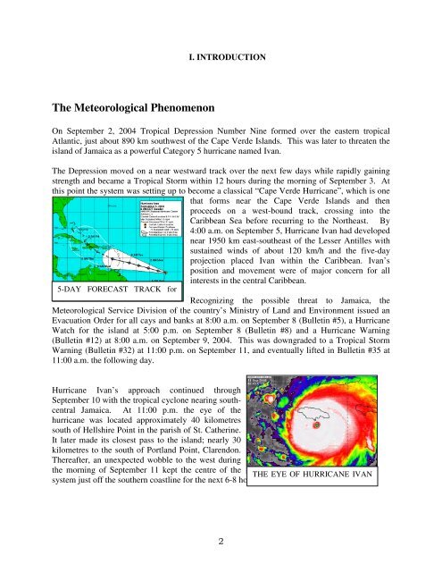
4:00 a.m. on September 5, Hurricane Ivan had developed<br />
near 1950 km east-southeast <strong>of</strong> the Lesser Antilles with<br />
sustained winds <strong>of</strong> about 120 km/h <strong>and</strong> the five-day<br />
projection placed Ivan within the Caribbean. Ivan’s<br />
position <strong>and</strong> movement were <strong>of</strong> major concern for all<br />
interests in the central Caribbean.<br />
5-DAY FORECAST TRACK for<br />
Recognizing the possible threat to <strong>Jamaica</strong>, the<br />
Meteorological Service Division <strong>of</strong> the country’s Ministry <strong>of</strong> L<strong>and</strong> <strong>and</strong> Environment issued an<br />
Evacuation Order for all cays <strong>and</strong> banks at 8:00 a.m. on September 8 (Bulletin #5), a Hurricane<br />
Watch for the isl<strong>and</strong> at 5:00 p.m. on September 8 (Bulletin #8) <strong>and</strong> a Hurricane Warning<br />
(Bulletin #12) at 8:00 a.m. on September 9, 2004. This was downgraded to a Tropical Storm<br />
Warning (Bulletin #32) at 11:00 p.m. on September 11, <strong>and</strong> eventually lifted in Bulletin #35 at<br />
11:00 a.m. the following day.<br />
Hurricane Ivan’s approach continued through<br />
September 10 with the tropical cyclone nearing southcentral<br />
<strong>Jamaica</strong>. At 11:00 p.m. the eye <strong>of</strong> the<br />
hurricane was located approximately 40 kilometres<br />
south <strong>of</strong> Hellshire Point in the parish <strong>of</strong> St. Catherine.<br />
It later made its closest pass to the isl<strong>and</strong>; nearly 30<br />
kilometres to the south <strong>of</strong> Portl<strong>and</strong> Point, Clarendon.<br />
Thereafter, an unexpected wobble to the west during<br />
the morning <strong>of</strong> September 11 kept the centre <strong>of</strong> the<br />
THE EYE OF HURRICANE IVAN<br />
system just <strong>of</strong>f the southern coastline for the next 6-8 hours.<br />
2