Jamaica: Macro-Socio-Economic and Environmental Assessment of ...
Jamaica: Macro-Socio-Economic and Environmental Assessment of ...
Jamaica: Macro-Socio-Economic and Environmental Assessment of ...

Create successful ePaper yourself
Turn your PDF publications into a flip-book with our unique Google optimized e-Paper software.
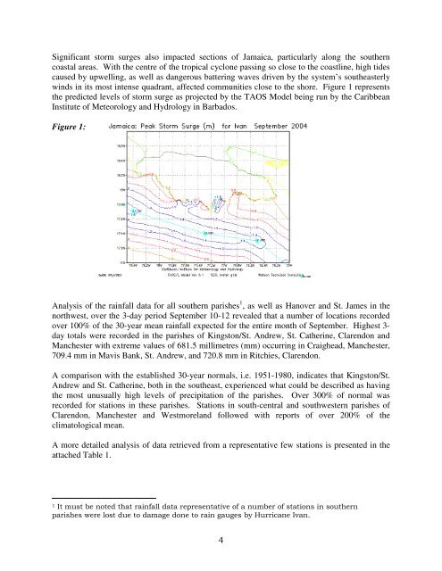
Significant storm surges also impacted sections <strong>of</strong> <strong>Jamaica</strong>, particularly along the southern<br />
coastal areas. With the centre <strong>of</strong> the tropical cyclone passing so close to the coastline, high tides<br />
caused by upwelling, as well as dangerous battering waves driven by the system’s southeasterly<br />
winds in its most intense quadrant, affected communities close to the shore. Figure 1 represents<br />
the predicted levels <strong>of</strong> storm surge as projected by the TAOS Model being run by the Caribbean<br />
Institute <strong>of</strong> Meteorology <strong>and</strong> Hydrology in Barbados.<br />
Figure 1:<br />
Analysis <strong>of</strong> the rainfall data for all southern parishes 1 , as well as Hanover <strong>and</strong> St. James in the<br />
northwest, over the 3-day period September 10-12 revealed that a number <strong>of</strong> locations recorded<br />
over 100% <strong>of</strong> the 30-year mean rainfall expected for the entire month <strong>of</strong> September. Highest 3-<br />
day totals were recorded in the parishes <strong>of</strong> Kingston/St. Andrew, St. Catherine, Clarendon <strong>and</strong><br />
Manchester with extreme values <strong>of</strong> 681.5 millimetres (mm) occurring in Craighead, Manchester,<br />
709.4 mm in Mavis Bank, St. Andrew, <strong>and</strong> 720.8 mm in Ritchies, Clarendon.<br />
A comparison with the established 30-year normals, i.e. 1951-1980, indicates that Kingston/St.<br />
Andrew <strong>and</strong> St. Catherine, both in the southeast, experienced what could be described as having<br />
the most unusually high levels <strong>of</strong> precipitation <strong>of</strong> the parishes. Over 300% <strong>of</strong> normal was<br />
recorded for stations in these parishes. Stations in south-central <strong>and</strong> southwestern parishes <strong>of</strong><br />
Clarendon, Manchester <strong>and</strong> Westmorel<strong>and</strong> followed with reports <strong>of</strong> over 200% <strong>of</strong> the<br />
climatological mean.<br />
A more detailed analysis <strong>of</strong> data retrieved from a representative few stations is presented in the<br />
attached Table 1.<br />
1 It must be noted that rainfall data representative <strong>of</strong> a number <strong>of</strong> stations in southern<br />
parishes were lost due to damage done to rain gauges by Hurricane Ivan.<br />
4