Volcanoes - Ministry of Civil Defence and Emergency Management
Volcanoes - Ministry of Civil Defence and Emergency Management
Volcanoes - Ministry of Civil Defence and Emergency Management

Create successful ePaper yourself
Turn your PDF publications into a flip-book with our unique Google optimized e-Paper software.
DEFORMATION<br />
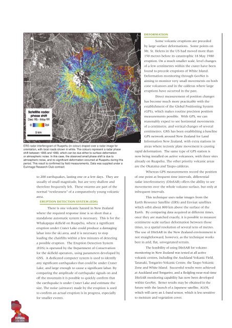
ERS radar interferogram <strong>of</strong> Ruapehu (in colour) draped over a radar image for<br />
orientation, with local roads shown in white. The colours represent a radar phase<br />
shift between 1995 <strong>and</strong> 1999, which can be due either to surface deformation<br />
or atmospheric noise. In this case, the observed small phase shift is due to<br />
atmospheric noise, <strong>and</strong> no significant deformation occurred at Ruapehu during this<br />
period. This result is confirmed by field measurements. Data was supplied under a<br />
Eurimage Research Club contract.<br />
to 200 earthquakes, lasting one or a few days. They are<br />
usually <strong>of</strong> small magnitude, but are very shallow <strong>and</strong><br />
therefore frequently felt. These swarms are part <strong>of</strong> the<br />
normal “restlessness” <strong>of</strong> a comparatively young volcanic<br />
area.<br />
ERUPTION DETECTION SYSTEM (EDS)<br />
There is one volcanic hazard in New Zeal<strong>and</strong><br />
where the required response time is so short that a<br />
st<strong>and</strong>alone automatic system is necessary. This is for the<br />
Whakapapa skifield on Ruapehu, where a significant<br />
eruption under Crater Lake could produce a damaging<br />
lahar into the ski area, <strong>and</strong> it is necessary to stop<br />
loading the chairlifts within a few minutes <strong>of</strong> detecting<br />
a possible eruption. The Eruption Detection System<br />
(EDS) is operated by the Department <strong>of</strong> Conservation<br />
for the skifield operators, using parameters developed by<br />
GNS. A dedicated computer system is used to identify<br />
any significant earthquakes that could be under Crater<br />
Lake, <strong>and</strong> large enough to cause a significant lahar. By<br />
comparing the amplitude <strong>of</strong> earthquake signals on <strong>and</strong><br />
<strong>of</strong>f the mountain it is possible to quickly confirm that<br />
the earthquake is under Crater Lake <strong>and</strong> estimate the<br />
size. The noise (airwave) made by the eruption is used<br />
to confirm an actual eruption is in progress, especially<br />
for smaller events.<br />
Some volcanic eruptions are preceded<br />
by large surface deformations. Some points on<br />
Mt. St. Helens in the US had moved more than<br />
150 metres before its catastrophic 18 May 1980<br />
eruption. On a much smaller scale, level changes<br />
<strong>of</strong> a few centimetres within the crater have been<br />
found to precede eruptions <strong>of</strong> White Isl<strong>and</strong>.<br />
Deformation monitoring through GeoNet is<br />
aiming to monitor very small movements on both<br />
cone volcanoes <strong>and</strong> in the calderas where large<br />
eruptions have occurred in the past.<br />
Direct measurement <strong>of</strong> position changes<br />
has become much more practicable with the<br />
establishment <strong>of</strong> the Global Positioning System<br />
(GPS), which makes routine precision position<br />
measurements possible. With GPS, we can<br />
reasonably expect to see horizontal movements<br />
<strong>of</strong> a centimetre, <strong>and</strong> vertical changes <strong>of</strong> several<br />
centimetres. GNS has been establishing a baseline<br />
GPS network around New Zeal<strong>and</strong> for L<strong>and</strong><br />
Information New Zeal<strong>and</strong>, with extra stations in<br />
areas where tectonic plate movement is causing<br />
rapid deformation. The same type <strong>of</strong> GPS station is<br />
now being installed on active volcanoes, with three sites<br />
already on Ruapehu. The other priority volcanic areas<br />
are the Okataina <strong>and</strong> Taupo calderas.<br />
Whereas GPS measurements record the position<br />
<strong>of</strong> one point at frequent time intervals, differential<br />
radar interferometry (DInSAR) <strong>of</strong>fers the ability to see<br />
movements over the whole volcano surface, but only at<br />
infrequent intervals.<br />
This technique uses radar images from the<br />
Earth Resource Satellite (ERS) <strong>and</strong> Envisat satellites<br />
which orbit about 800 km above the surface <strong>of</strong> the<br />
Earth. By comparing data acquired at different times,<br />
once they are matched exactly, it is possible to measure<br />
centimetre-scale surface deformation between those<br />
times, to a spatial resolution <strong>of</strong> several tens <strong>of</strong> metres.<br />
The use <strong>of</strong> DInSAR in the New Zeal<strong>and</strong> environment is<br />
not straightforward, however, as the technique works<br />
best in arid, flat, unvegetated terrain.<br />
The feasibility <strong>of</strong> using DInSAR for volcano<br />
monitoring in New Zeal<strong>and</strong> was tested at all active<br />
volcanic centres, including the Auckl<strong>and</strong> Volcanic Field,<br />
Taranaki, Tongariro Volcanic Centre, the Taupo Volcanic<br />
Zone <strong>and</strong> White Isl<strong>and</strong>. Successful results were achieved<br />
at Auckl<strong>and</strong> <strong>and</strong> Tongariro, <strong>and</strong> a fledgling near-real-time<br />
DInSAR monitoring capability has now been developed<br />
within GeoNet. Better results may be obtained in the<br />
future with the launch <strong>of</strong> a Japanese satellite, ALOS,<br />
which will carry an L-b<strong>and</strong> sensor, which is less sensitive<br />
to moisture <strong>and</strong> vegetation cover.<br />
14<br />
TEPHRA<br />
June 2004