Volcanoes - Ministry of Civil Defence and Emergency Management
Volcanoes - Ministry of Civil Defence and Emergency Management
Volcanoes - Ministry of Civil Defence and Emergency Management

You also want an ePaper? Increase the reach of your titles
YUMPU automatically turns print PDFs into web optimized ePapers that Google loves.
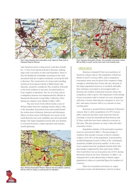
Fig 3. Lake Tarawera area evacuation route. Spencer Road west to<br />
Tarawera Road to Rotorua.<br />
Fig 5. Kawerau Evacuation Routes. Two possible evacuation routes:<br />
NE via SH30; or south via the main road or the forestry road.<br />
Lake Tarawera <strong>and</strong> is a long narrow road that extends<br />
for ~17 km, from Tarawera Road to Rotorua, making<br />
large-scale evacuation on this road hazardous. There is<br />
also the likelihood <strong>of</strong> l<strong>and</strong>slips occurring on the road,<br />
associated with pre-eruption seismicity, severing the link<br />
to Rotorua. The construction <strong>of</strong> a loop road extending<br />
northwest from Spencer Road to Millar Road, Lake<br />
Okareka, should be considered. This would be <strong>of</strong> benefit<br />
to the local residents at any time, but particularly so<br />
if an eruption is imminent. The use <strong>of</strong> a loop road as<br />
a mitigation measure was implemented by <strong>of</strong>ficials at<br />
Mammoth Mountain (Long Valley, California, USA)<br />
during an eruption scare (Mader & Blair, 1987).<br />
The next level <strong>of</strong> risk will be inside a zone <strong>of</strong><br />
40 kms radius from the erupting volcano (Fig.2). This<br />
is the Secondary Evacuation Zone <strong>and</strong> would include<br />
the urban areas <strong>of</strong> Rotorua, Kawerau <strong>and</strong> Murupara.<br />
Effects on these towns will depend very much on the<br />
wind direction, but such variability puts all in potential<br />
danger. The larger population means that any decision<br />
to evacuate becomes a major operation <strong>and</strong> requires<br />
careful planning.<br />
Fig 4. Rotorua Evacuation Routes. Rotorua has two options: south by<br />
SH 30 or SH 5 to Taupo; or west by SH 5 to Hamilton.<br />
URBAN AREAS<br />
Rotorua is situated 25 km west-northwest <strong>of</strong><br />
Tarawera volcano (Fig 4). The population <strong>of</strong> Rotorua<br />
district is 64,473 (Census 2001), <strong>and</strong> a compulsory<br />
evacuation notice may be given if the eruption is large<br />
enough or wind direction is from the east. Because <strong>of</strong><br />
the larger population however, it would be advisable<br />
that voluntary evacuation is encouraged earlier, to<br />
decrease the number <strong>of</strong> potential evacuees where the<br />
compulsory order is given. The importance <strong>of</strong> the timing<br />
<strong>of</strong> any evacuation order is critical: too soon, <strong>and</strong> people<br />
will start to return, believing the emergency is over; too<br />
late, <strong>and</strong> many evacuees will try to evacuate at once,<br />
causing panic.<br />
Kawerau is situated 20 km northeast <strong>of</strong> Tarawera<br />
volcano (Fig 5), with a population <strong>of</strong> 6,975 (Census<br />
2001). Kawerau has three main road exits from its<br />
township. It must be remembered that Rotorua <strong>and</strong><br />
Te Teko could also have been ordered to evacuate at<br />
this time. This puts pressure on some roads <strong>and</strong> other<br />
evacuation routes.<br />
Population statistics <strong>of</strong> the potential evacuation<br />
areas are presented in Table 3. The percentage <strong>of</strong><br />
residents who actually evacuate is hard to estimate.<br />
A figure <strong>of</strong> 50-70% <strong>of</strong> the population, is presented by<br />
Auckl<strong>and</strong> Regional Council (1996) as the “anticipated<br />
maximum credible [evacuee] number” in the event<br />
<strong>of</strong> an eruption from the Auckl<strong>and</strong> volcanic field. This<br />
percentage is supported by Dow <strong>and</strong> Cutter (2002)<br />
who found there was an evacuation rate <strong>of</strong> 65% during<br />
Hurricane Floyd in the USA. Therefore, in Table 3, an<br />
estimated 60% <strong>of</strong> the affected Bay <strong>of</strong> Plenty region<br />
population is taken as a potential figure for numbers <strong>of</strong><br />
evacuees.<br />
Plans for evacuation movement, ie. major<br />
evacuation routes <strong>and</strong> destinations, must be in place<br />
48<br />
TEPHRA<br />
June 2004