Volcanoes - Ministry of Civil Defence and Emergency Management
Volcanoes - Ministry of Civil Defence and Emergency Management
Volcanoes - Ministry of Civil Defence and Emergency Management

Create successful ePaper yourself
Turn your PDF publications into a flip-book with our unique Google optimized e-Paper software.
comprehensive diagnostic set <strong>of</strong> information for<br />
predicting changes in volcanic activity, <strong>and</strong> assessing<br />
volcanic hazard.<br />
EVENT RESPONSE<br />
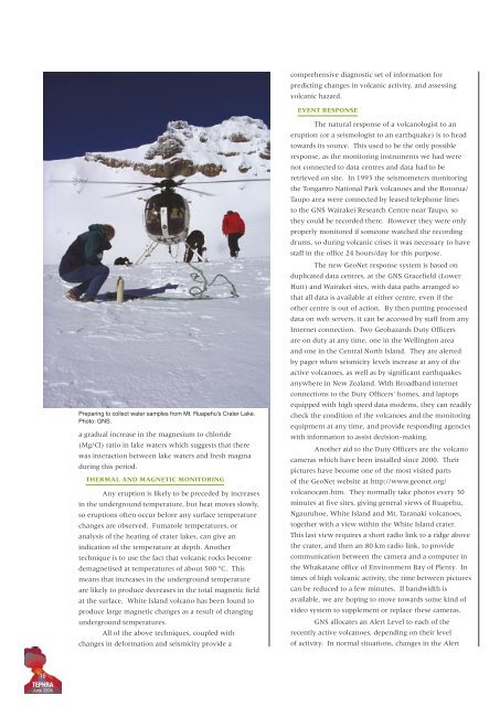
Preparing to collect water samples from Mt. Ruapehu's Crater Lake.<br />
Photo: GNS.<br />
a gradual increase in the magnesium to chloride<br />
(Mg/Cl) ratio in lake waters which suggests that there<br />
was interaction between lake waters <strong>and</strong> fresh magma<br />
during this period.<br />
THERMAL AND MAGNETIC MONITORING<br />
Any eruption is likely to be preceded by increases<br />
in the underground temperature, but heat moves slowly,<br />
so eruptions <strong>of</strong>ten occur before any surface temperature<br />
changes are observed. Fumarole temperatures, or<br />
analysis <strong>of</strong> the heating <strong>of</strong> crater lakes, can give an<br />
indication <strong>of</strong> the temperature at depth. Another<br />
technique is to use the fact that volcanic rocks become<br />
demagnetised at temperatures <strong>of</strong> about 500 ºC. This<br />
means that increases in the underground temperature<br />
are likely to produce decreases in the total magnetic field<br />
at the surface. White Isl<strong>and</strong> volcano has been found to<br />
produce large magnetic changes as a result <strong>of</strong> changing<br />
underground temperatures.<br />
All <strong>of</strong> the above techniques, coupled with<br />
changes in deformation <strong>and</strong> seismicity provide a<br />
The natural response <strong>of</strong> a volcanologist to an<br />
eruption (or a seismologist to an earthquake) is to head<br />
towards its source. This used to be the only possible<br />
response, as the monitoring instruments we had were<br />
not connected to data centres <strong>and</strong> data had to be<br />
retrieved on site. In 1993 the seismometers monitoring<br />
the Tongariro National Park volcanoes <strong>and</strong> the Rotorua/<br />
Taupo area were connected by leased telephone lines<br />
to the GNS Wairakei Research Centre near Taupo, so<br />
they could be recorded there. However they were only<br />
properly monitored if someone watched the recording<br />
drums, so during volcanic crises it was necessary to have<br />
staff in the <strong>of</strong>fice 24 hours/day for this purpose.<br />
The new GeoNet response system is based on<br />
duplicated data centres, at the GNS Gracefield (Lower<br />
Hutt) <strong>and</strong> Wairakei sites, with data paths arranged so<br />
that all data is available at either centre, even if the<br />
other centre is out <strong>of</strong> action. By then putting processed<br />
data on web servers, it can be accessed by staff from any<br />
Internet connection. Two Geohazards Duty Officers<br />
are on duty at any time, one in the Wellington area<br />
<strong>and</strong> one in the Central North Isl<strong>and</strong>. They are alerted<br />
by pager when seismicity levels increase at any <strong>of</strong> the<br />
active volcanoes, as well as by significant earthquakes<br />
anywhere in New Zeal<strong>and</strong>. With Broadb<strong>and</strong> internet<br />
connections to the Duty Officers' homes, <strong>and</strong> laptops<br />
equipped with high speed data modems, they can readily<br />
check the condition <strong>of</strong> the volcanoes <strong>and</strong> the monitoring<br />
equipment at any time, <strong>and</strong> provide responding agencies<br />
with information to assist decision-making.<br />
Another aid to the Duty Officers are the volcano<br />
cameras which have been installed since 2000. Their<br />
pictures have become one <strong>of</strong> the most visited parts<br />
<strong>of</strong> the GeoNet website at http://www.geonet.org/<br />
volcanocam.htm. They normally take photos every 30<br />
minutes at five sites, giving general views <strong>of</strong> Ruapehu,<br />
Ngauruhoe, White Isl<strong>and</strong> <strong>and</strong> Mt. Taranaki volcanoes,<br />
together with a view within the White Isl<strong>and</strong> crater.<br />
This last view requires a short radio link to a ridge above<br />
the crater, <strong>and</strong> then an 80 km radio link, to provide<br />
communication between the camera <strong>and</strong> a computer in<br />
the Whakatane <strong>of</strong>fice <strong>of</strong> Environment Bay <strong>of</strong> Plenty. In<br />
times <strong>of</strong> high volcanic activity, the time between pictures<br />
can be reduced to a few minutes. If b<strong>and</strong>width is<br />
available, we are hoping to move towards some kind <strong>of</strong><br />
video system to supplement or replace these cameras.<br />
GNS allocates an Alert Level to each <strong>of</strong> the<br />
recently active volcanoes, depending on their level<br />
<strong>of</strong> activity. In normal situations, changes in the Alert<br />
16<br />
TEPHRA<br />
June 2004